
Bohoniki
Bohoniki | |
|---|---|
Village | |
 Mosque in Bohoniki (2021) | |
 Bohoniki | |
| Coordinates: 53°23′N 23°36′E / 53.383°N 23.600°E | |
| Country | |
| Voivodeship | Podlaskie |
| County | Sokółka |
| Gmina | Sokółka |
| Population | |
| • Total | 100 |

Bohoniki [bɔxɔˈniki] (Polish Arabic: بوـحـونيكي) is a village in the administrative district of Gmina Sokółka, within Sokółka County, Podlaskie Voivodeship, in north-eastern Poland, close to the border with Belarus.[1] It lies approximately 7 kilometres (4 mi) east of Sokółka and 42 km (26 mi) north-east of the regional capital Białystok.
Bohoniki was primarily a Lipka Tatar settlement. Today, still a few families in the village are Tatars and practicing Muslims. Although residents don't speak their native Tatar language (often written in Latin, Cyrillic or Arabic alphabet), they have close ties to Lipka Tatar and Islamic traditions.[2]
Sites of interest in the village include a 19th-century wooden mosque and a Muslim cemetery.
The village was named one of Poland's official national Historic Monuments (Pomnik historii), as designated November 20, 2012. Its listing is maintained by the National Heritage Board of Poland.
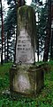
Muslim cemetery[edit]
-
 Entrance
 -
 Muslim Lipka Tatar cemetery sign
 -
 Damaged tombstone
 -
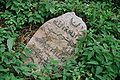 Ruthenian language Arabic script of a tombstone
 -

-

-

-
-


References[edit]
- ^ "Central Statistical Office (GUS) - TERYT (National Register of Territorial Land Apportionment Journal)" (in Polish). 2008-06-01.
- ^ Leonard Drożdżewicz (2016). "Biographical Dictionary of Polish Tatars of the Twentieth Century" (PDF). Znad Wilii. 4 (68): 77–82.

| International | |
|---|---|
| National | |
This Sokółka County location article is a stub. You can help Wikipedia by expanding it. |