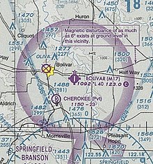
Bolivar Municipal Airport
Bolivar Municipal Airport Gene Engledow Field | |||||||||||
|---|---|---|---|---|---|---|---|---|---|---|---|
| Summary | |||||||||||
| Airport type | Public | ||||||||||
| Owner | City of Bolivar | ||||||||||
| Operator | S.O.A.R. (Service Oriented Aviation Readiness) | ||||||||||
| Serves | Bolivar, Missouri | ||||||||||
| Elevation AMSL | 1,092 ft / 333 m | ||||||||||
| Coordinates | 37°35′46″N 093°20′52″W / 37.59611°N 93.34778°W | ||||||||||
| Maps | |||||||||||
 | |||||||||||
| Runways | |||||||||||
| |||||||||||
| Statistics (2008) | |||||||||||
| |||||||||||
Bolivar Municipal Airport (FAA LID: M17) is a city-owned public-use airport located four nautical miles (4.6 mi, 7.4 km) east of the central business district of Bolivar, a city in Polk County, Missouri, United States.[1] It is included in the FAA's National Plan of Integrated Airport Systems for 2011–2015, which categorized it as a general aviation facility.[2]
History[edit]
By proclamation of the mayor of the city of Bolivar, the field was renamed "Bolivar Municipal Airport, Gene Engledow Field" on October 12, 2013.[3] The renaming was to honor Gene Engledow, a local 100-year-old master pilot. Engledow has been licensed by the FAA for 77 years as of 2013.[4]
Facilities and aircraft[edit]
Bolivar Municipal Airport covers an area of 183 acres (74 ha) at an elevation of 1,092 feet (333 m) above mean sea level. It has one runway designated 18/36 with an asphalt surface measuring 4,000 by 75 feet (1,219 x 23 m).[1]
For the 12-month period ending May 30, 2011, the airport had 18,701 aircraft operations, an average of 51 per day: 96% general aviation, 2% air taxi, 2% military. As of October 17, 2013, there were 51 aircraft based at this airport: 45 single-engine (88%), two multi-engine (4%), three jet (6%), and one helicopter (2%).[1]
On October 10, 2011, S.O.A.R. (Service Oriented Aviation Readiness) began service as the FBO.
See also[edit]
References[edit]
- ^ a b c d FAA Airport Form 5010 for M17 PDF. Federal Aviation Administration. Effective 30 June 2011.
- ^ National Plan of Integrated Airport Systems for 2011–2015: Appendix A (PDF, 2.03 MB) Archived September 27, 2012, at the Wayback Machine. Federal Aviation Administration. Updated 4 October 2010.
- ^ "Airfield named after Gene Engledow".
- ^ "Pilot readies for flight on 100th birthday - KY3". Archived from the original on 2013-11-05. Retrieved 2013-11-03.
External links[edit]
- S.O.A.R, the fixed-base operator
- "Bolivar Municipal (M17)" (PDF). Archived from the original (PDF) on 2012-08-25. Retrieved 2011-07-10. at MoDOT Airport Directory
- Aerial photo as of 10 March 1996 from USGS The National Map
- FAA Terminal Procedures for M17, effective April 18, 2024
- Resources for this airport:
- FAA airport information for M17
- AirNav airport information for M17
- FlightAware airport information and live flight tracker
- SkyVector aeronautical chart for M17

