
Bonanza, Utah
Bonanza | |
|---|---|
 Bonanza Power Plant | |
 Location in Uintah County and the state of Utah | |
| Coordinates: 40°01′49″N 109°11′18″W / 40.03028°N 109.18833°W | |
| Country | United States |
| State | Utah |
| County | Uintah |
| Settled | 1888 |
| Named for | Rich Gilsonite deposits |
| Elevation | 5,466 ft (1,666 m) |
| Population (2020) | |
| • Total | 0 |
| Time zone | UTC-5 (Mountain (MST)) |
| • Summer (DST) | UTC-4 (MDT) |
| ZIP code | 84008 |
| Area code | 435 |
| GNIS feature ID | 2584757[1] |
Bonanza is a census-designated place in eastern Uintah County, Utah, United States. The name refers to a rich mineral strike.[2]
Near the community is a coal-fired power plant owned by Deseret Power Electric Cooperative. Bonanza is also in the area of the Colorado Plateau where oil drilling and extraction takes place from oil shale and other fossil fuel deposits. According to the 2010 Census, Bonanza has a population of 0.[3]
History[edit]
Bonanza was established in 1888. The basis for establishing the community was a discovery of Gilsonite, a natural asphalt substance.[4]
Geography[edit]
Bonanza is 212 miles (341 km) southeast of Salt Lake City and is located on State Route 45.
Climate[edit]
According to the Köppen Climate Classification system, Bonanza has a semi-arid climate, abbreviated "BSk" on climate maps.[5]
See also[edit]
References[edit]
- ^ a b U.S. Geological Survey Geographic Names Information System: Bonanza, Utah. Retrieved May 17, 2011.
- ^ Leigh, Rufus Wood (1961). Five hundred Utah place names: their origin and significance. Salt Lake City: Deseret News Press. p. 7.
- ^ "U.S. Census website". United States Census Bureau. Retrieved May 21, 2022.
- ^ Rivero, Nicolas (August 25, 2017). "The Smallest Town in Each of the 50 States". Mental Floss. Retrieved June 25, 2018.
- ^ Climate Summary for Bonanza, Utah
External links[edit]
Municipalities and communities of Uintah County, Utah, United States | ||
|---|---|---|
| Cities | 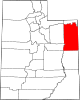 | |
| CDPs | ||
| Other communities | ||
| Indian reservation | ||
| Ghost town | ||
| Footnotes | ‡This populated place also has portions in an adjacent county or counties | |
| International | |
|---|---|
| National | |
This article about a location in Utah is a stub. You can help Wikipedia by expanding it. |