
Byrnedale, Pennsylvania
Byrnedale, Pennsylvania | |
|---|---|
 Byrnedale | |
| Coordinates: 41°17′32″N 78°30′16″W / 41.29222°N 78.50444°W | |
| Country | United States |
| State | Pennsylvania |
| County | Elk |
| Township | Jay |
| Area | |
| • Total | 1.25 sq mi (3.24 km2) |
| • Land | 1.25 sq mi (3.24 km2) |
| • Water | 0.00 sq mi (0.00 km2) |
| Elevation | 1,225 ft (373 m) |
| Population | |
| • Total | 382 |
| • Density | 305.60/sq mi (117.96/km2) |
| Time zone | UTC-5 (Eastern (EST)) |
| • Summer (DST) | UTC-4 (EDT) |
| ZIP code | 15827 |
| FIPS code | 42-10600 |
| GNIS feature ID | 1170843 |
Byrnedale is an unincorporated community and census-designated place in Elk County, Pennsylvania. As of the 2020 census, the population was 382.[3][4]
It is located in Jay Township, in the valley of Kersey Run, and is bordered to the south by Weedville. Pennsylvania Route 255 passes through Byrnedale, leading north 11 miles (18 km) to St. Marys and southwest 20 miles (32 km) to DuBois.
Demographics[edit]
| Census | Pop. | Note | %± |
|---|---|---|---|
| 2010 | 427 | — | |
| 2020 | 382 | −10.5% | |
| U.S. Decennial Census[5][2] | |||
References[edit]
- ^ "ArcGIS REST Services Directory". United States Census Bureau. Retrieved October 12, 2022.
- ^ a b "Census Population API". United States Census Bureau. Retrieved October 12, 2022.
- ^ https://data.census.gov/table?q=Byrnedale+CDP;+Pennsylvania
- ^ "Geographic Identifiers: 2010 Demographic Profile Data (G001): Byrnedale CDP, Pennsylvania". American Factfinder. U.S. Census Bureau. Archived from the original on February 13, 2020. Retrieved March 14, 2016.
- ^ "Census of Population and Housing". Census.gov. Retrieved June 4, 2016.
Municipalities and communities of Elk County, Pennsylvania, United States | ||
|---|---|---|
| City | 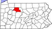 | |
| Boroughs | ||
| Townships | ||
| CDPs | ||
| Unincorporated communities | ||
External links[edit]
- Byrnedale PA – Start-up website for the city of Byrnedale PA
This Elk County, Pennsylvania state location article is a stub. You can help Wikipedia by expanding it. |