Cerhovice
Cerhovice | |
|---|---|
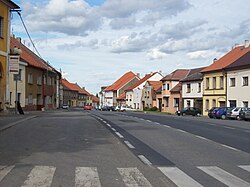
 Square and main road in Cerhovice | |
| Coordinates: 49°50′59″N 13°50′6″E / 49.84972°N 13.83500°E | |
| Country | |
| Region | Central Bohemian |
| District | Beroun |
| First mentioned | 1275 |
| Area | |
| • Total | 8.10 km2 (3.13 sq mi) |
| Elevation | 411 m (1,348 ft) |
| Population (2023-01-01)[1] | |
| • Total | 1,201 |
| • Density | 150/km2 (380/sq mi) |
| Time zone | UTC+1 (CET) |
| • Summer (DST) | UTC+2 (CEST) |
| Postal code | 267 61 |
| Website | www |
Cerhovice is a market town in Beroun District in the Central Bohemian Region of the Czech Republic. It has about 1,200 inhabitants.
Administrative parts[edit]
The village of Třenice is an administrative part of Cerhovice.
Geography[edit]
Cerhovice is located about 19 kilometres (12 mi) southwest of Beroun and 42 km (26 mi) southwest of Prague. It lies on the border between the Hořovice Uplands and Křivoklát Highlands. The highest point is the hill Třenická hora at 500 m (1,600 ft) above sea level.
History[edit]
The first written mention of Cerhovice is in a deed of King Ottokar II of Bohemia from 1275. The village was promoted to a market town in 1516 by King Vladislaus II. The market town was a royal property until 1557, when it was purchased by the Lobkowicz family. Their properties were confiscated as a punishment for preparing an uprising against the king in 1595, and the royal chamber regained Cerhovice.[2]
Demographics[edit]
|
|
| ||||||||||||||||||||||||||||||||||||||||||||||||||||||
| Source: Censuses[3][4] | ||||||||||||||||||||||||||||||||||||||||||||||||||||||||
Transport[edit]
The D5 motorway from Prague to Plzeň leads south of the market town.
Cerhovice is located on thr railway line Plzeň–Beroun.[5]
Sights[edit]

The main landmark of Cerhovice is the Church of Saint Martin. It was originally a Gothic building from the first half of the 14th century. After the church was damaged by fire in 1728, it was rebuilt in the Baroque style in 1730.[6]
There is a steel telecommunication tower on Třenická hora, which serves as an observation tower. It was opened in 2007 and is 30 m (98 ft) high.[7]
References[edit]
- ^ "Population of Municipalities – 1 January 2023". Czech Statistical Office. 2023-05-23.
- ^ "Historie" (in Czech). Městys Cerhovice. Retrieved 2023-03-08.
- ^ "Historický lexikon obcí České republiky 1869–2011 – Okres Beroun" (in Czech). Czech Statistical Office. 2015-12-21. pp. 1–2.
- ^ "Population Census 2021: Population by sex". Public Database. Czech Statistical Office. 2021-03-27.
- ^ "Detail stanice Cerhovice" (in Czech). České dráhy. Retrieved 2024-01-28.
- ^ "Kostel sv. Martina" (in Czech). National Heritage Institute. Retrieved 2023-03-08.
- ^ "Informace o rozhledně Třenická hora". Rozhlednovým rájem (in Czech). Retrieved 2023-03-08.


