
Chaudière Falls (Chaudière River)
You can help expand this article with text translated from the corresponding article in French. (February 2017) Click [show] for important translation instructions.
|
| Chaudière Falls | |
|---|---|
| French: Chutes de la Chaudière | |
.jpg) | |
 | |
| Location | Lévis, Quebec |
| Coordinates | 46°42′53″N 71°16′57″W / 46.71472°N 71.28250°W[1] |
| Type | Segmented block |
| Total height | 35 metres (115 ft) |
| Total width | 240 m (790 ft) |
| Watercourse | Chaudière River |
| Average flow rate | 500 m3/s (18,000 cu ft/s)[2] |
Chaudière Falls (French: Chutes de la Chaudière) is a 35-meter-high (115 ft) waterfall in Lévis, Quebec along the Chaudière River. It is part of the regional Parc des Chutes-de-la-Chaudière, which features a 113-metre-long (371 ft) suspension footbridge standing 23 metres over the river.[3] There are walking and bicycle trails along the river.
Gallery[edit]
-
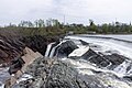 View from the top of the Chaudière Falls
 -
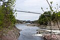 Footbridge on the Chaudière River
 -
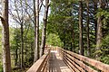 Walking trail in the park


See also[edit]
References[edit]
- ^ Querying Geographical Names of Canada - Query by name Archived 2011-06-08 at the Wayback Machine
- ^ "Graphique des données à une station hydrométrique". www.cehq.gouv.qc.ca. Retrieved 2020-11-04.
- ^ "Parc des Chutes-de-la-Chaudière". Visitez Lévis. Retrieved 30 November 2016.
External links[edit]
 Media related to Chaudière Falls (Rivière Chaudière) at Wikimedia Commons
This waterfall-related article is a stub. You can help Wikipedia by expanding it. |
This Chaudière-Appalaches location article is a stub. You can help Wikipedia by expanding it. |