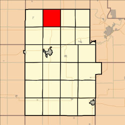
Cheever Township, Dickinson County, Kansas
Cheever Township | |
|---|---|
 Location in Dickinson County | |
| Coordinates: 39°05′30″N 097°14′31″W / 39.09167°N 97.24194°W | |
| Country | United States |
| State | Kansas |
| County | Dickinson |
| Area | |
| • Total | 35.88 sq mi (92.94 km2) |
| • Land | 35.87 sq mi (92.9 km2) |
| • Water | 0.02 sq mi (0.04 km2) 0.04% |
| Elevation | 1,332 ft (406 m) |
| Population (2000) | |
| • Total | 149 |
| • Density | 4.2/sq mi (1.6/km2) |
| GNIS feature ID | 0476308 |
Cheever Township is a township in Dickinson County, Kansas, USA. As of the 2000 census, its population was 149.
Cheever Township was organized in 1873.[1]
Geography[edit]
Cheever Township covers an area of 35.88 square miles (92.9 km2) and contains no incorporated settlements. According to the USGS, it contains one cemetery, Henry.
Further reading[edit]
References[edit]
External links[edit]

