
Cherry Lane, North Carolina
Cherry Lane, North Carolina | |
|---|---|
| Country | United States |
| State | North Carolina |
| County | Alleghany |
| Elevation | 2,854 ft (870 m) |
| Time zone | Eastern (EST) |
| • Summer (DST) | EDT |
| ZIP codes | 28668 |
| GNIS feature ID | 983084[1] |
Cherry Lane is an unincorporated community located in the Cherry Lane Township of Alleghany County, North Carolina, United States.[1] The community was settled circa 1838 and was named for the cherry tree-bordered lane that led to the home of local resident Frank Bryan.[2] The community is located along U.S. Highway 21, near its junction with the Blue Ridge Parkway in southeastern Alleghany County.
See also[edit]
References[edit]
Works cited[edit]
- Powell, William S. (1968). The North Carolina Gazetteer: A Dictionary of Tar Heel Places. Chapel Hill: University of North Carolina Press. ISBN 0-8078-1247-1.
36°26′31″N 81°01′05″W / 36.4420759°N 81.0181349°W
Municipalities and communities of Alleghany County, North Carolina, United States | ||
|---|---|---|
| Town | 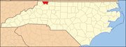 | |
| Townships | ||
| Unincorporated communities | ||