
Coșereni
Coșereni | |
|---|---|
 Police station in Coșereni | |
 Coat of arms | |
 Location in Ialomița County | |
 Coșereni Location in Romania | |
| Coordinates: 44°40′N 26°33′E / 44.667°N 26.550°E | |
| Country | Romania |
| County | Ialomița |
| Government | |
| • Mayor (2020–2024) | Lucian Tudorache (PNL) |
| Area | 34.37 km2 (13.27 sq mi) |
| Elevation | 57 m (187 ft) |
| Population (2021-12-01)[1] | 4,195 |
| • Density | 120/km2 (320/sq mi) |
| Time zone | EET/EEST (UTC+2/+3) |
| Postal code | 927095 |
| Area code | +(40) 243 |
| Vehicle reg. | IL |
Coșereni is a commune located in Ialomița County, Muntenia, Romania, about 50 km (31 mi) to the northeast of Bucharest. It is composed of a single village, Coșereni.
Geography[edit]
The commune is situated in the Wallachian Plain, on the right bank of the Ialomița River. It is located in the western part of Ialomița County, 8 km (5.0 mi) southwest of Urziceni and 70 km (43 mi) west of the county seat, Slobozia.
Coșereni is crossed by national road DN2 (part of European route E85 on this stretch), a road which links Bucharest with the historical regions of Moldavia and Bukovina in northeastern Romania. County road DJ201 branches off in Coșereni, going west towards Slobozia and Țăndărei.
History[edit]
On October 30, 1992, the singers Doina and Ion Aldea Teodorovici died following a road accident in Coșereni. A monument was erected where the accident took place.[2]
Natives[edit]
- Nicolae Condeescu (1876 – 1936), general
- Marian Neacșu (born 1964), politician and former convict
References[edit]
- ^ "Populaţia rezidentă după grupa de vârstă, pe județe și municipii, orașe, comune, la 1 decembrie 2021" (XLS). National Institute of Statistics.
- ^ "Slobozia: Coșereni, loc de pelerinaj la comemorarea artiștilor Ion și Doina Aldea Teodorovici". Adevărul (in Romanian). October 30, 2010. Retrieved February 14, 2024.
External links[edit]
-
 DN2 entering the village of Coșereni
 -
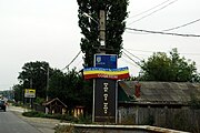
 Doina and Ion Aldea Teodorovici monument near Coșereni


This Ialomița County location article is a stub. You can help Wikipedia by expanding it. |