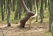
Dancing Forest
The Dancing Forest (Russian: Танцующий лес, romanized: Tantsuyushchiy les) is a pine forest on the Curonian Spit in Kaliningrad Oblast, Russia noted for its unusually twisted trees. Unlike drunken trees, the trees in the Dancing Forest are twisted into several patterns, such as rings, hearts and convoluted spirals bending to the ground.[1] The exact cause of the trees' distortion is unknown.[2] According to one version, the distortion is caused by the activity of the caterpillar of Rhyacionia buoliana.[3] In the folk version, the Dancing Forest follows the movement of the sands.[1]Trees of such unusual shapes are found throughout the Curonian Spit.


55°10′48″N 20°51′43″E / 55.18000°N 20.86194°E
History[edit]
The trees were planted in the 1960s.[2] Before World War II the site accommodated a Nazi German gliding school.[2]
See also[edit]
References[edit]
- ^ a b Daria Gonzales (August 23, 2013). "Curonian Spit: Tiny national park on the Baltic coast". Russia Beyond the Headlines. Archived from the original on November 7, 2018. Retrieved 31 January 2015.
- ^ a b c "The Curonian Spit". Cultural Heritage of Russia. Archived from the original on 1 February 2015. Retrieved 31 January 2015.
- ^ "Kurshskaya Kosa National Park". Field Ecology Center "Ecosystem". Retrieved 31 January 2015.
