
Dargan Bridge, Belfast

Dargan Bridge is a railway bridge which crosses the River Lagan in Belfast, Northern Ireland. Opened in 1994, it directly connected the Newry and Bangor lines with the lines to Larne and Derry for the first time. It is named after the Irish railway engineer William Dargan and is the longest bridge on the island of Ireland.[1]
History[edit]
Northern Ireland Railways first proposed what was then called the 'Cross Harbour Link' in 1978. Construction was scheduled to begin in 1980, however the project was cancelled by the direct rule government in 1979.[2] The scheme was later revived and was included in the urban area plan which was published in 1990.[3] In preparation for the new line, Yorkgate station was opened on 17 October 1992, replacing York Road Station. The bridge was then constructed and opened to traffic on 28 November 1994. It was officially opened by Elizabeth II on 9 March 1995.[4]
Structure[edit]
Dargan Bridge is a concrete viaduct 4,675 feet (1,425 m) in length and is parallel to Lagan Bridge. It carries a single-track railway, which has a passing loop as it crosses Corporation Street. There was planned to be a station here called Donegall Quay, which was originally due to open in 1997, but so far it has not been built.[2]
Gallery[edit]
-
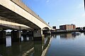 Dargan Bridge (right), October 2009
 -
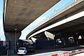 Dargan Bridge (left), October 2009
,_October_2009.JPG)
,_October_2009.JPG)
See also[edit]
References[edit]
- ^ Institution of Civil Engineers. "Belfast cross-harbour road and rail bridges". Retrieved 16 February 2024.
- ^ a b Rowledge, J. W. P. (1995). A Regional History of Railways: Volume XVI: Ireland. Penryn: Atlantic Transport Publishers. pp. 221–224. ISBN 090689963X.
- ^ "Belfast Urban Area Plan 2001 | Planning Portal". wayback.archive-it.org. Retrieved 16 February 2024.
- ^ Johnson, Stephen (1997). Johnson's Atlas and Gazetteer of the Railways of Ireland. Leicester: Midland Publishing Limited. p. 127. ISBN 1857800443.
54°36′9″N 5°55′13″W / 54.60250°N 5.92028°W
This article about a bridge in the United Kingdom is a stub. You can help Wikipedia by expanding it. |
This article about a Northern Ireland building or structure is a stub. You can help Wikipedia by expanding it. |