
Dieupentale
Dieupentale | |
|---|---|
 The roundabout on the Route de Toulouse | |
.svg) Coat of arms | |
Location of Dieupentale  | |
 Dieupentale  Dieupentale | |
| Coordinates: 43°51′48″N 1°16′12″E / 43.8633°N 1.27°E | |
| Country | France |
| Region | Occitania |
| Department | Tarn-et-Garonne |
| Arrondissement | Montauban |
| Canton | Verdun-sur-Garonne |
| Government | |
| • Mayor (2020–2026) | Dominique Julien[1] |
| Area 1 | 6.14 km2 (2.37 sq mi) |
| Population (2021)[2] | 1,634 |
| • Density | 270/km2 (690/sq mi) |
| Time zone | UTC+01:00 (CET) |
| • Summer (DST) | UTC+02:00 (CEST) |
| INSEE/Postal code | 82048 /82170 |
| Elevation | 95–154 m (312–505 ft) (avg. 108 m or 354 ft) |
| 1 French Land Register data, which excludes lakes, ponds, glaciers > 1 km2 (0.386 sq mi or 247 acres) and river estuaries. | |
Dieupentale (French pronunciation: [djøpɛ̃tal]; Occitan: Diupentala) is a commune in the Tarn-et-Garonne department in the Occitanie region in southern France. Dieupentale station has rail connections to Toulouse, Montauban and Brive-la-Gaillarde.
Monuments[edit]
-
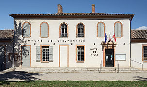 The town hall.
 -
 Castle de Laparre Saint-Sernin.
 -
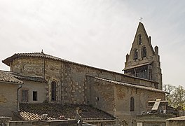 The Church.
 -
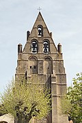 The bell tower.
 -
 War memorial.
 -
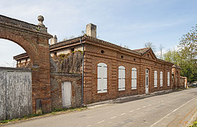
 The old town hall.


See also[edit]
References[edit]
- ^ "Répertoire national des élus: les maires" (in French). data.gouv.fr, Plateforme ouverte des données publiques françaises. 13 September 2022.
- ^ "Populations légales 2021". The National Institute of Statistics and Economic Studies. 28 December 2023.
Wikimedia Commons has media related to Dieupentale.
| Authority control databases: National |
|---|
This Tarn-et-Garonne geographical article is a stub. You can help Wikipedia by expanding it. |