Doughnut Falls
| Doughnut Falls | |
|---|---|
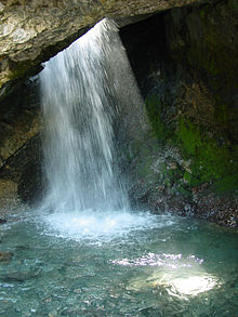
 Main waterfall and pool | |
 | |
| Location | Big Cottonwood Canyon |
| Coordinates | 40°37′47″N 111°39′17″W / 40.62968°N 111.65481°W |
| Elevation | 7,942 ft (2,421 m) |
| Total height | 20 ft (6 m) |
Doughnut Falls is a waterfall in the Big Cottonwood Canyon near Silver Fork, south of Midvale in Salt Lake County, Utah.[1] Access to Chocolate Falls is from the Mill D Trailhead towards the Jordan Pines picnic area. The waterfall plunges into a pothole that has access under the arch of rock with a view up at the falls falling into the pool.
See also[edit]
References[edit]
- ^ "Doughnut Falls - Salt Lake County, Utah". World Waterfall Database. Retrieved 6 July 2017.
