Draft:Kalma Union 2
Kalma
কলমা | |
|---|---|
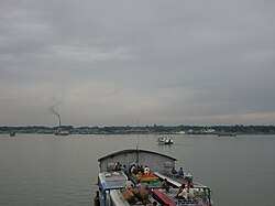
 Skyline of Kalma, Lohajang, Munsiganj, Bangladesh | |
 | |
| Coordinates: 23°28′05″N 90°19′59″E / 23.467980°N 90.333120°E | |
| Country | |
| Division | Dhaka |
| District | Munshiganj |
| Area | |
| • Total | 12.62 km2 (4.87 sq mi) |
| Population (2022) | |
| • Total | 28,932 |
| • Density | 2,300/km2 (5,900/sq mi) |
| Time zone | UTC+6 (BST) |
| Website | kalmaup |
Kalma (Bengali: কলমা [meaning Water spinach or Devi of Hinduism name Kali]) is an union of Louhajang upazila of Munshiganj District[1] in the Division of Dhaka, Bangladesh.
Geography[edit]
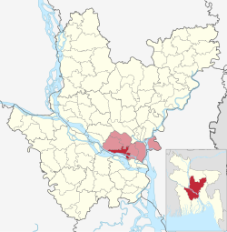
Kalma is located at 23°28′05″N 90°19′59″E / 23.467980°N 90.333120°E on the south bank of Padma River. It has a total area of 3055.35
Demographics[edit]
| Year | Pop. (000) | ±% |
|---|---|---|
| 1981 | — | |
| 1991 | — | |
| 2001 | — | |
| 2011 | 18,744 | — |
| 2022 | 28,932 | +54.4% |
| Source: Bangladesh Bureau of Statistics[2] | ||
Information[edit]
According to the 2022 Bangladesh census, Kalma Union had 4546 households. Louhajang had a literacy rate (age 7 and over) of 60%, compared to the national average of 66%, and a sex ratio of 1000 females per 1070 males.[3]
History[edit]
In 1757, after the fall of Nawab Sirajudaula in the desert of Palashi, Bengal's independence dawned. Some of the faithful Hindu Muslims of the defeated and slain Nawab left Murshidabad and took refuge in the eastern part of Bengal. One of them is Dewan Nidhiram. The Bhagirathi of Murshidabad floated barges in favor of the current and migrated to this region of East Bengal. Dewan Nidhiram passed Rajnagar, Rajbari, Mirbahar, Telirbagh, Akiyadhal and came further north to find a proper place to avoid Pramatta Padma and settle somewhere far away and saw a bill. Kalmi prices cover most of the bill than Shapla Shaluq. People used to say 'Bill Kalmi'. Hence Bill Kalma is now 'Kalma'. Moreover, Nidhiram dug a large lake in Kalma and built a temple on the western side of the lake. Krishna brought the stone idol of Kali from Kashi and established the house deity there. Since then it is known as Kalma Kali Bari. [4]
Education[edit]
- University or College - 1
- Primary schools - 9
- Secondary School - 1
- Madrasas - 6
Economics[edit]
Mostly agriculturists, potatoes and rice are the main cash crops here. Also jute, maize, ankh, mustard, black cumin are also regularly produced. Moreover, remittances sent by expatriates are also one of the reasons for the prosperity of this area.
Notable Persons[edit]
- Kaliprasanna Ghosh - Literary (July 23, 1843 - October 29, 1910)
- Mizanur Rahman Sinha - Bangladeshi industrialist, politician and former Minister of State for Health
- Ibrahim Nirob is a Bangladeshi Student Leaders, Activists & Litterateur
Sightseeing[edit]
- Mizanur Rahman Sinha's house
- Kalma L, K High School and Zamindar Bari
- Dhaida Hafizia Qawmia Madrasa [4]
- Daspara temple
References[edit]
See also[edit]
- ^ Helen Nawshin (2021), "Lohajang Upazila", in Mohammad Ali Mollah (ed.), Banglapedia: National Encyclopedia of Bangladesh (Second ed.)
- ^ Cite error: The named reference
census2011was invoked but never defined (see the help page). - ^ a b "Bangladesh Population and Housing Census 2022 Zila Report – Munshiganj" (PDF). bbs.gov.bd. Bangladesh Bureau of Statistics.
- ^ a b Cite error: The named reference
kalmaup.munshiganj.gov.bdwas invoked but never defined (see the help page).
