
Draft:Negev in biblical times
| Draft article not currently submitted for review.
This is a draft Articles for creation (AfC) submission. It is not currently pending review. While there are no deadlines, abandoned drafts may be deleted after six months. To edit the draft click on the "Edit" tab at the top of the window. To be accepted, a draft should:
It is strongly discouraged to write about yourself, your business or employer. If you do so, you must declare it. Where to get help
How to improve a draft
You can also browse Wikipedia:Featured articles and Wikipedia:Good articles to find examples of Wikipedia's best writing on topics similar to your proposed article. Improving your odds of a speedy review To improve your odds of a faster review, tag your draft with relevant WikiProject tags using the button below. This will let reviewers know a new draft has been submitted in their area of interest. For instance, if you wrote about a female astronomer, you would want to add the Biography, Astronomy, and Women scientists tags. Editor resources
Last edited by DaWalda (talk | contribs) 2 seconds ago. (Update) |
| This is a draft article. It is a work in progress open to editing by anyone. Please ensure core content policies are met before publishing it as a live Wikipedia article. Find sources: Google (books · news · scholar · free images · WP refs) · FENS · JSTOR · TWL Last edited by DaWalda (talk | contribs) 2 seconds ago. (Update)
Finished drafting? or |
Biblical[edit]
Extent of biblical Negev[edit]
According to Israeli archaeologists, in the Hebrew Bible, the term Negev only relates to the northern, semiarid part of what we call Negev today; of this, the Arad-Beersheba Valley, is accordingly defined as "the eastern (biblical) Negev".[1] The highland area in the actual central Negev is probably called "Mount Seir"[2][3][4][5][6] (which older research placed east of the Jordan, because this area was believed to be the heartland of the Edomites. See below).
Biblical reference[edit]

The Bible contains several traditions about the Beersheba-Arad Valley and the Negev Highlands: (1) According to the Book of Genesis, already Abraham lived for a while in the Negev after being banished from Egypt.[7] Accordingly, Numbers 34:1–7[8] is generally understood to mean that it actually belonged to God's Promised Land at least down to Kadesh Barnea. The northern part of the Negev is assigned to the Tribe of Judah and the southern part to the Tribe of Simeon. Hence, when the Israelites came from Egypt to Israel, according to Numbers 20:1–21:3,[9] only Aaron is not allowed to enter this land because he has sinned — the rest of the Israelites, however, can conquer the area.
(2) Conversely, according to Numbers 1–2,[10] the area is revoked from the Israelites by God because everyone has sinned.[11] (3) According to Genesis 32:3; 33:12–16,[12] it is not Jacob, the ancestor of the Israelites, who lives there, but his brother Esau, the ancestor of the Edomites, and the two brothers divide the promised land between them in Genesis 36:6–8[13] so that this "Edomite land" will continue to be inhabited by Edomites. (4) According to the Books of Kings, the Edomites also live here. They are sometimes ruled by Israelite kings, as the Negev was part of the Kingdom of the legendary king Solomon (in its entirety, all the way to the Red Sea), and then, with varied extension to the south, part of the Kingdom of Judah.[14] But the Edomites are able to successfully fight against them multiple times and regain their freedom.[15][16]
Archaeology shows us that these traditions (2)-(4) are likely intended to explain why the area was seen as part of the promised land, but in fact, it was continually not inhabited by Israelites, but by another ethnic group:
Iron Age[edit]
The copper miners of the Negev Highlands[edit]

In the Bronze Age (up to the 13th century BCE), the Egyptians operated a copper mine in the Timna Valley, as evidenced by a Hathor temple from that period.[17] After the Egyptians withdrew, it appears that another ethnic group took over the copper mine. Geographically, this ethnic group is believed to be identical to the "Shasu," as several Egyptian texts from this period attest to their presence in this region.[18] It is suggested that from this ethnic group, the Edomites emerged later, and even later, the Idumeans (see below). This group also built a fortress-like road station at the Yotvata oasis, which was notably constructed using the casemate building technique,[19] and established another copper mine at Khirbet en-Nahas.[20]
In the Beersheba—Arad Valley, a complex of several casemate buildings also emerged in the 12th century BCE, known as Tel Masos,[21][22] the region′s first capital (until it was replaced by nearby Tel Malhata as the new capital from the 10th to the 8th century BCE.[23][24]). From Tel Masos and Yotvata, this architectural style spread throughout the Negev region between the 11th to 8th centuries BCE, with sites like Tel Esdar, Khirbet en-Nahas, Beersheba and Arad adopting similar structures. Additionally, during this time, many more farms, known as "haserim" ("enclosed homesteads"), developed, especially along the streams and brooks up to the vicinity of the Philistine locations Nahal Patish and Tell el-Far'ah (South). Gazit notes that there were 36 Haserim of at least 0.25 hectares in size in the 11th century alone in the region, along with many smaller farms.[25] Moreover, in the same period, about 60 small casemate buildings (which are called "Negev fortresses" because of the casemate construction method) appeared in the Negev Highlands.[26] Many of these sites also had additional smaller buildings, totaling several hundred.[27][28][29][30]
These settlements were likely involved in operating the copper mines, which is supported by the presence of copper slags from the Arabah in Negevite pottery.[31][32][33][34][35][36] The excavated pottery also shows that trade relations flourished, connecting the Negevites with Judeans, Philistines, Phoenicians, and even Arabs from the Arabian Peninsula.[37][38]
Desert agriculture in the Iron Age?[edit]

| External images | |
|---|---|
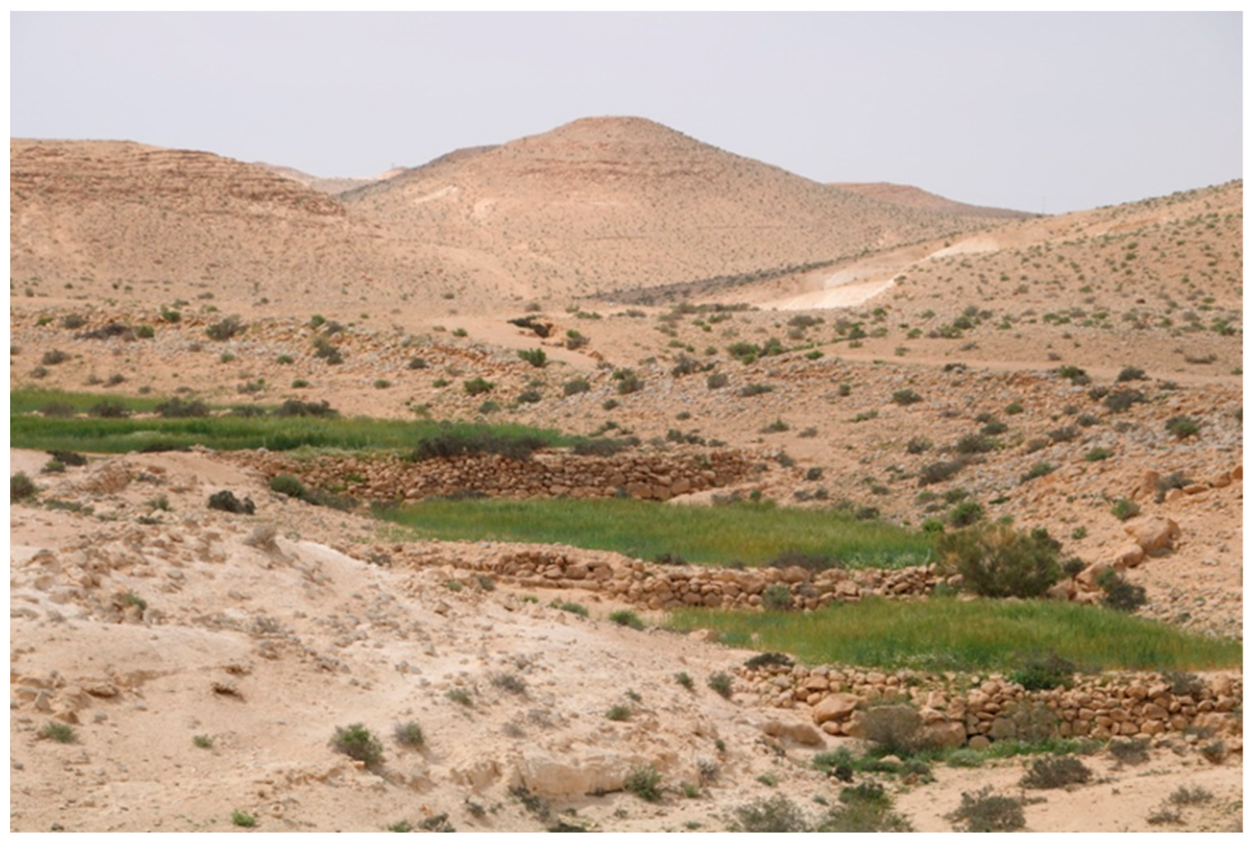
The sheer number of Early Iron Age buildings in the Negev Highlands (surveys have registered nearly 450 in total[42]) is surprising given the area's low rainfall — typically less than 200 mm/year, which is far below the assumed necessary 400 mm/year for agriculture. However, the Negevites seem to have developed innovative agricultural techniques to cope with these conditions: They built their buildings near the small wadis of the Negev Highlands, where they carved cisterns into the rock to capture and store winter rainwater.[43] They also constructed terraced fields along these wadis, designed to channel flowing water from the wadis and running water from the wadi slopes to plants and slow drainage, thus maximizing moisture retention and minimizing soil erosion. Michael Evenari demonstrated at his experimental Avdat farm that this farming method could successfully grow even grapes with less than 100 ml/year of rainfall.[44]
However, interpretations differ regarding the timing of terrace construction. It is clear that the majority of the millions[45] of wadi terraces still found in the Negev today originated in the Byzantine and Early Islamic periods[46][47][48] (see below). But excavated blades, silos and threshing floors from the Iron Age[49] combined with new Radiocarbon[50] and OSL datings[51][52] suggest that some terraces were built as early as the Iron Age or even earlier.[53][54] Thus, already Evenari distinguished between two different types of ancient terraces: those roughly built with large stones, which he dates to the Iron Age, and those more finely constructed with smaller stones and rubble infill, which he believes were built starting from the Roman period.[55][56]
Conversely, research teams led by Israel Finkelstein investigated ancient dung heaps in the Negev mountains and at the Timna mines and discovered that in the Negev, small livestock primarily grazed on wild-growing winter and spring plants,[57][58][59] while in the Timna area, they were mainly fed hay and grape pomace.[60][59] Accordingly, they suggest that the practice of crop cultivation in the Negev mountains during the rainy season might have started later. If this is true, the Iron Age Negevites seem to have lived in the Negev mountains during the rainy season, but they only practiced livestock farming there. During the summer time, they moved south to mine copper and imported grain and grape pomace from the Philistines and Judeans in the north. If one agrees with the early dating of the agricultural terraces instead, it appears that the Negevites´ society was structured such that they lived in the Negev mountains during the rainy season, engaging in crop and vine cultivation to stockpile supplies; during the summer, they moved down to the copper mines, mined copper, and fed their animals with the stored hay and grape pomace.
Superpowers in the Negev and the end of the mining era[edit]
The military situation of the Negevites and their neighboring peoples as well as territorial fluctuations at this time largely depended on the surrounding political superpowers:
- In the 10th century BCE, Pharaoh Shoshenq I conquered large parts of Palestine, including the Negev region, briefly bringing the Negevites back under Egyptian influence.[61][62][63]
- With Hazael's conquest of Palestine in the 9th century, the Judeans in the north strengthened and also expanded into the Beersheba-Arad Valley, as evidenced by the ceramics found in Arad and Aroer.[64]
At this time, the end of copper mining in the Negev region appears to have been caused by deforestation. From the 12th to the 9th century BCE, copper mining was gradually intensified to such an extent that by the 9th century, a total of 23,000 tons per year were being extracted solely at Khirbet en-Nahas.[65] This, however, led to an overexploitation of natural resources, which eventually brought copper production to a complete halt, as indicated by the analysis of charcoal remains.[66][67][68]
Following the decline of copper mining, the Negevites appear to have increasingly focused on trade to the east. Camels seem to have been regularly used for trade starting from this period, as excavated camel and dromedary bones from the late 10th and early 9th centuries BCE suggest.[69][70] It was also only from this time on that they expanded to the east of the Jordan river and founded Bozra and subsequently other towns along the King's Highway, which until recently were considered the "core territory" of Edom.[71][72][73][74][75][76] The pottery found in these areas suggests that the same ethnic groups lived here as in the central Negev and (temporarily alongside Judeans[77][78][79][80][81]) in the Beersheba-Arad Valley.
- The subsequent conquest of Palestine by the Assyrians in the 8th century meant a political and economic upswing for the Negevites (like the Philistines and in contrast to the Judeans). Following this, they expanded further east in the Beersheba-Arad Valley, beyond the borders shown on the map above, to places such as Horvat Qitmit, Horvat Uza, Horvat Radum, Mizpe Zohar, and the Gorer Tower.[82][83][84][85]
- However, it was the conquest of Palestine by the Babylonians in the 6th century BCE that had the most significant impact on regional history. The Judean region north of the Negevites was almost completely destroyed, after which the Negevites advanced north into the more fertile Central Palestine. It is likely this invasion that the pronounced hatred for "Edom" in the later biblical texts originates from.[86][87][88][89] The Negev highlands and the region east of the Jordan were abandoned; subsequent survey results show that only 11 sites can be identified in the highlands from the following period.[42]
This regional situation remained for the next few centuries: According to Diodorus Siculus and Josephus, even in the 1st century BCE and CE, the border between Judea and the Negevites ("Idumaea") was at the same level, namely "between Beth-zur and Hebron" or "near Gaza."[90][91]
Nabateans, Maccabees, and Romans[edit]
Nabataeans[edit]


During this period, also the Idumeans living in ancient Edom east of the Jordan river were displaced by invading Arabian Qedarites and moved to join their kin in southern Judah. Soon after, sometimes between the late 4th and early 2th century BC, these Qedarites were themselves pushed northwestward by the invading Nabateans.[92][93] As a result, the Idumeans and Qedarites intermingled in southern Judah,[94] while the Nabateans settled in the former territories of Edom and the Negev, taking control of these areas and the ancient trade routes.[95] They established the so-called "desert towns" located along the Negev incense route at Avdat, Mampsis, Rehovot, Shivta, Nessana, and especially Elusa, which was to become the new capital and the only polis of the Negev.[96][97]
Early Nabataean desert agriculture?[edit]
Previously, it was believed that the early Nabateans were responsible for the terraced fields in the Negev Highlands, but archaeological evidence does not support this claim.[98][99] Instead, the Nabateans are rightly famous for two other innovations in the arid desert landscape. First, they developed characteristic arched cisterns. More importantly, second, they constructed aqueducts: The Nabateans appear to have been the first to build long water channels[100] from perennial springs to their cities and villages (as in En Erga, En Ziq, and Qasr Ruheibeh in the central Negev, and En Rahel and Moyat Awad in the Arabah), which functioned in their early time mainly not as agricultural farms but as caravan stops and trade stations.[101]
Maccabees and Romans[edit]
The Books of the Maccabees report that the Maccabees conquered the Idumean border towns of Maresha and Adoraim and presented the Idumeans with a choice: convert to Judaism or leave the region.[102] Unlike similar accounts about Galilee reported by Josephus, this could be true for Idumea: During the Maccabean era, almost the entire region was depopulated, mostly without signs of conflict.[103][104] Following the Roman replacement of the Maccabees as rulers of Palestine it was again repopulated between the 1st century BC and the 1st century AD up to Hebron by people who continued to practice the Idumean religion.[105]
According to the Books of the Maccabees and Josephus, the Maccabees did not advance into the central and southern Negev. Hence, archaeological excavations in these areas reveal that the Nabataean religion was practiced there without interruption until the beginning of the Islamic period in the 7th century.[106] Nabatean control of the Negev only ended when the Roman empire annexed their lands in 106 CE.[96]
Byzantine and early Islamic Period[edit]
Byzantine population growth[edit]

Iron Age: Era of the copper miners.
Persian Period: Copper miners relocate to Judaea.
Hellenistic/Roman: Nabataeans migrate to the Negev Highlands.
Byzantine/Early Islamic: Christian settlement wave and Arab expansion.
During the 4th century, Byzantine rule brought Christianity to the region. This, coupled with a stable political climate,[108] led to a substantial population growth throughout the whole region.[96] Immigrating Christians most frequently settled in the area of today's West Bank down to the Beersheba Valley, which had been most thoroughly ethnically cleansed of Judeans by the Romans. In the Beersheba Valley alone, the number of settlements surged from 47 in the Roman period (up to the 4th century) to 321 during the Byzantine era (4th - early 7th centuries); Beersheba expanded to an area of 90–140 ha,[109] making it even larger than nearby Gaza and Anthedon, each covering about 90 ha.[110]
One of the three additional clusters of Christian settlements were the Nabatean desert towns: Tamar, Mampsis, Avdat, Shivta, Rehovot and Nessana.[111] The last five of these evolved into large agricultural villages with many smaller farms and villages around them.[112] Ultimately, the whole central Negev, extending down roughly to the Ramon Crater, was dotted with hundreds of small agricultural villages and farms. These were likely operated by Nabataeans assimilated to the Byzantine Empire,[113][114] after Nabatean trade had declined starting from late Roman times.[115] Also, Eilat ("Ayla") at the Gulf of Aqaba grew from a village to an important Roman port city with its own bishopric.
Islamic Expansion[edit]
From 602 to 628, the Byzantine military was severely depleted during the Byzantine-Sassanian War and regained control over Palestine only with great difficulty. After that, despite forming alliances with several Bedouin tribes, such as the Banu Judham, the Banu Lakhm, and Banu Ghassan, who were migrating from the Arabian Peninsula to the southern Negev during this period,[116] the Arab forces encountered little resistance in their Islamic expansion into Palestine beginning in AD 634. By around AD 636, with the decisive Battle of the Yarmuk, the war was largely decided.
As mostly in the rest of Palestine, the Islamic expansion left no archaeological trace in the Negev:[117][118]
[...N]ot even one of the Negev towns was affected by the Islamic conquest. No hint of a violent invasion or destruction, or even a slight change in the material culture is found in the large-scale excavations of the sites. The archaeological findings point to an uninterrupted pattern of settlement which continued from the Byzantine period into the later stages of the early Islamic period.
— Gideon Avni[119]
| External image | |
|---|---|
Unlike in the case of the Christians, who, for instance, forcibly converted the hellenized pagans of Post-Philistia during Byzantine times, there are also no clear signs of religious wars and forced conversions in the case of the Muslim invasion. In Nessana, it even appears that the same building was used simultaneously as both a church and a mosque. Similarly, in Nahal Oded (on the southwestern slope of the Ramon Crater), the same building seems to have served as a pagan cult place and a mosque at the same time.[121] Related to this phenomenon is the fact that the early Palestinian Muslims even integrated the Christian festivals of Easter, Pentecost, Christmas, and Saint Barbara into the Muslim calendar.[122] Therefore, on the eve of the Crusades, Palestine was still predominantly Christian.[123] Hence, Ibn al-Arabi, who visited Palestine at the end of the 11th century, could still write: "The country is theirs [the Christians'] because it is they who work its soil, nurture its monasteries and maintain its churches."[124]
Deurbanization and desert agriculture[edit]
Deurbanization and ruralization[edit]
The Arabic invasion, however, accelerated a trend toward deurbanization and ruralization, especially in the Negev, which had already started in Byzantine times, to which a number of factors contributed:
- By the end of the Byzantine period, Christianity had become widespread in Palestine; however, within Christianity, the characteristic aspects of Roman-Byzantine urban culture were viewed as promoting unchristian frivolity. Consequently, urban institutions such as Roman baths, theaters, and arenas began to be dismantled or destroyed from this time onward, reducing the appeal and hence the pull factors of cities.[125][126][127]
- Many monks, whose monasteries often served as the Christian centers of smaller towns (as in Avdat and Nessana[128]) left Palestine after the Arab invasion, diminishing another pull factor of these towns.[129]
- A drought during the Late Antique Little Ice Age in the early sixth century, a plague that broke out in the densely populated cities of southern Palestine in the mid-sixth century (→ Plague of Justinian), and a severe earthquake in the Negev toward the start of the early Islamic period further drove urban populations to the countryside, where they now had to fend for themselves.[130][131][132]
- In Southern Palestine, a new economic sector emerged due to the strong demand for "Gaza wine," which was primarily produced in Yavneh, Ashkelon, and Gaza.[133] To capitalize on this, some inhabitants of the Negev towns took up viticulture in the countryside.[134][135][136] Curiously, viticulture and trade with Gaza wine continued unabated in the first Islamic century[137] and even the Arabs themselves praised the quality of Palestinian wine.[138] After the wine trade collapsed, it seems that the vineyards were instead continued to be used for olive cultivation.[139]
- The Arab conquest and the Muslim imposition of two new taxes called Jizya and Kharaj on non-Muslims and non-Bedouins led to the cessation of the flow of Christian immigrants. The absence of Christian pilgrims also dried up financial flows,[140] prompting even more Palestinians to turn back to subsistence farming.
Already in the Byzantine period, 90% of the settlements in the Negev were agricultural farms and villages. Following the decline of the towns during the early Islamic period, the total number of settlements gradually decreased,[nb 1] yet the proportion of agricultural villages among these settlements further increased. According to Rosen, this shift of life from cities to rural areas is the reason why most early mosques are found in rural areas.[145] Also, further to the south, around the Ramon Crater at the southern fringes of the Negev highlands, the Negev Bedouin replicated the terrace architecture and incorporated agriculture into their now semi-nomadic lifestyle.[146] Haiman estimates that during the early Islamic period, there would have been about 300 individual farms, each with 80–100 residents, cultivating a total of approximately 6,500 hectares of agricultural land (nearly 3% of the total area of the Negev Highlands).[147]
Byzantine and early Islamic desert agriculture[edit]
If agriculture was already practiced on terraces during the Iron Age, this system was certainly further developed from the Byzantine period onwards:
- Starting with the Byzantine period the Negevites stacked stone heaps, called Tuleilat el-Anab ("grape mounds"),[148] to further facilitate the flow of rainwater into the wadis[149] and probably also to reduce evaporation in the soil beneath these heaps for growing grape vines.[nb 2]
- They also constructed artificial dovecotes alongside the terraces, so that the pigeons could fertilize the agriculturally used soil with their droppings.[153][154]
- Finally, the most sophisticated irrigation system dates back to the early Islamic period: The inhabitants of the arid area around Yotvata in the southern Negev constructed tunnel systems known as "qanat," spanning several kilometers. These tunnels served as irrigation channels, directly connecting groundwater reservoirs to agricultural fields covering several hundred hectares.[155][156][157]
The end of the desert towns[edit]
Meanwhile, the desert towns gradually died a quiet death: Elusa and Mampsis were abandoned either by the 7th or 8th century, Rehovot by the 8th century. The abandonment of Avdat is now also dated to the 8th century;[158] seemingly due to an earthquake.[159][160] The archaeologically poorly preserved Beersheba and its surroundings, including the revitalized towns Tel Masos, Tel Malhata and Tel Ira may also have been abandoned by the 8th or 9th century. However, Shivta, Nessana, and the large Khirbet Futais (in the area of the former Philistine Nahal Patish) continued to exist at least until the 10th century. In Ayla, where the new inhabitants of the region resumed mining copper and started to mine gold, there can even be observed further growth; the towns were only abandoned in the 11th century.[161][162][163][164]
From the 12th century onwards, as the Crusaders and then the Mamluks ravaged central and northern Palestine, most of the villagers and townspeople of the Negev had already migrated to these regions. This, the war waged by the Crusaders against Southern Palestine as well, and the (not certain but likely) fact that the Mamluks prohibited permanent settlements in the Negev, led to the transformation of the Negev into a region inhabited solely by semi-nomadic and predominantly Muslim Bedouins.[165]
Negev Bedouin[edit]
The cultural region of the Negev Bedouin[edit]

The territories of the Tarabin and the Aheiwat extend far into the Sinai Peninsula; however, the boundaries of their areas in this region are less well-known.
During the Byzantine period and continuing until the 19th century, the Negev and the Sinai Peninsula formed largely a single cultural area, with fluid and often changing borders and territorial allocations. The Romans grouped the Negev with most of the Sinai Peninsula into the province of "Palaestina Salutaris." The Mamluks largely retained this configuration, subdividing the area conceptually into the "Fahs al Tih" ("Area of the Wanderings [of the Israelites in Moses' time]"), which corresponded roughly to the enlarged southern part of today’s Palestine, but including Jabal Musa as the assumed Mount Sinai, and the neighboring area of "Al Jifâr" to the west, regularly also considered part of "Filastin."[167]
During the Ottoman period, the territorial boundaries of Palestine were often unclear, even to the Ottomans themselves.[168] Maps from the 15th century onward frequently depict Egypt bordered to the east by the Gulf of Suez, with Palestine ending to the south approximately along a line from Rafah to Beersheba (→ Cartography of Palestine), again leaving the Negev and the Sinai Peninsula as a unified "remainder". However, parts of this area were at times included within the frequently shifting[169] boundaries of the independently governed Gaza District. Displayed is a snapshot from 1835,[170] just before the territorial reorganizations of 1840, 1871-1874, and 1906.[171][172] Only with the last reorganization was the Palestinian Negev definitively separated from the rest of its cultural region. Galilee reports that as of 2019, Bedouins still regarded the regions on both sides of the arbitrarily drawn national border as a single region.[173]
The history of the Bedouins in this cultural area remains poorly researched. It is certain that the Bedouin tribes that migrated to Palestine in the pre-Islamic era, no longer exist there. It is also evident that the tribes inhabiting the Negev in the 20th/21st centuries are not the same as those documented in the 16th century.[174] However, this does not necessarily mean that the tribes currently living there are newcomers. One case is better documented and may serve as an example of the complex history of Bedouin tribes: The Bilī, attested in the Negev since pre-Islamic times, were a sub-tribe of the Wuhaydat in the 18th century and lived in the northern Negev near Gaza. After the Wuhaydat were displaced from there by the Tarabin and the Tiyaha, part of them merged with the aforementioned Tarabin; the other part merged with the Jabarat, whose territory is now in the eastern Negev.[175] A third part of the Bilī now lives again on the Sinai Peninsula.
Conversely, the Tiyaha, the Tarabin, and the Azazima as the three largest Negev tribes of today have been present in the Negev since the 19th century and are believed to have migrated from the Sinai Peninsula between the 18th and 19th centuries according to their traditions.[174]
History of Bedouin land use[edit]
Israeli discurse: Bedouin neglect of the desert environment?[edit]
Avni posits that also the agricultural terraces were abandoned concurrently with the decline of Negev towns and villages around the 10th / 11th century. He bases this conclusion on the premise that agricultural terraces required continual renovation, combined with observations that the most recent OSL dating of terrace sediments consistently points to the Byzantine/early Islamic period. From this, he infers that these dates also mark the terraces' last usage.[176][177][178]
At the same time, demonstrating Bedouin presence and activity from the 12th to the 17th century is challenging: Nomadic presence and activity is notoriously difficult to detect archaeologically. Bedouins can be relatively reliably identified through archaeological excavations mainly by findings of so-called "Black Gaza Ware" and typical Bedouin ceramic tobacco pipes. However, tobacco pipes only indicate that Bedouins were present and active at a location sometime between the 17th and the 20th century; Black Gaza Ware shows the same for either the 16th or 18th to the 20th century.[179][180][181] Thus, for instance, Steven Rosen suggests that the Bedouins did leave the Negev area after the 11th century and didn't return until the 18th century.[182]
Furthermore, particularly in Israel, there is a widespread discourse suggesting that sporadic Bedouin agriculture there began at the earliest with Ottoman, English, and Zionist settlement policies.[183][184][185] In Zionistic discourses, one could find even the idea that it was the "neglect" of agricultural land in the Negev by the Bedouins in previous times and overgrazing of Bedouin herds in recent history that led to its desertification.[186][187][188][189] According to Seligman, this was indeed still the prevailing opinion in 2012.[190][nb 3]
Historical evidence: Land use after 1100 AD[edit]
Both discourses, however, are grossly inaccurate and likely remnants of Orientalist and colonialist discourses from the 19th century:[194][195] To claim that Zionist settlement policies, beginning with the expulsion of Bedouins from Palestine during the Nakba around 1948, the expropriation of Bedouin landowners from the 1950s, the forced relocation of the remaining population to the "Siyagh" primarily from the 1960s, and the ongoing displacement from the remaining land through Zionist agriculture, the designation of "nature reserves", and the planting of pine forests,[196] promoted Bedouin agriculture, is even a severe case of historical revisionism (see more below).
Extensive Bedouin agriculture in the Negev also certainly predates the British Mandate period starting in the early 1920s, and almost certainly predates Ottoman land policies that began with the "Land Law" of 1858. However, demonstrating how far back Bedouin agriculture predates the Ottoman Land Law becomes increasingly difficult the further back in time one goes due to the specific archaeological evidence of nomads. Even with Gaza Ware, tobacco pipes, the Bedouin cemetery at Tel el-Hesi, which was in use from the 16th century, and an Ottoman tax register from the 16th century, no agricultural evidence can be proven. Therefore, reconstructing the further history of the Negev requires working with sparse evidence:
Evidence for the 12th to 18th centuries[edit]
For the for the 12th to 18th centuries, there are three pieces of evidence:
First, the Negevites cultivated not only wheat and barley on their terraces but also, in some places, fruit trees (especially fig and olive trees). Ashkenazi et al. have analyzed more than 100 of these, which still grow on the terraces today, even though Bedouins have been prohibited from accessing many of these locations since 1948. The trees were roughly divided into age groups: (A) 70-250 years, (B) 300-600 years, and (C) even older trees. The oldest tree is over 1000 years old.[197] These trees provide the clearest evidence that "nomadic [...] tribes, living in the Negev Highlands between the 10th and 18th centuries, [...] cultivated some of the best-preserved agricultural plots and primarily grew annual crops, such as cereals, and occasionally also managed small plots of fruit trees."[198] However, the extent of agriculture is hard to discern.
This also suggests that Avni's basic assumption appears to be incorrect. It is true that, in order to optimize agricultural yields, agricultural terraces would have needed to be continuously enhanced. However, the old terraces "functioned" even without such enhancements: Even for terraces where "younger" trees grow, OSL dates pointed to the Byzantine / early Islamic period.[199]
Second: In the region around Ayla in the southern Negev, where terrace farming was not previously common and the qanat system had been used for irrigation instead, new terraces were built after the 11th century. The oldest terrace dated post-11th century was constructed between the 14th and 16th centuries, with the next one built in the 16th century, followed by several more in the 17th and 18th centuries. This suggests that in this driest region of Palestine, agriculture was expanded after the 11th century, especially from the 17th century onwards.[200]
Third: An Ottoman tax register from 1596 lists about 4,000 taxable Bedouins in the area of the northern Negev between Rafah and Beersheba, among other more northerly places. These tax lists clearly indicate that some Bedouins in Palestine were engaged in agriculture and others in nomadic livestock farming at that time. However, for the Negev Bedouins, the records do not specify the types of taxes paid (such as barley tax, wheat tax, etc.).[201] Accordingly, these tax entries could imply that Bedouins were engaged in agriculture in this most fertile region of the Negev during the 16th century; however, this is not certain.
19th century[edit]
| External image | |
|---|---|
For the 19th century, alongside archaeological excavations, text documents are the primary pieces of evidence. Notably, there is a wealth of travel literature from the 19th century that frequently discusses the Negev region, as well as the first ethnological studies, and some newspaper articles about Gaza trade.
Avi Oppenheimer[203] and the authors of "Emptied Lands"[204] have analyzed travel reports. From these, it is particularly clear that Bedouins cultivated wheat throughout the northern Negev.
It is well documented and widely known from early travelers' accounts that the Negev Bedouins as a whole, or sedentary parts of individual tribes, were already engaged in intensive agriculture in the area north of Gaza and Beersheba during this period (Thomson, 1856: "wheat, wheat, a very ocean of wheat [...], but there is not a village along the entire route, and all the grain belonged to tent-dwelling Arabs."[205]).
The Negev Bedouins of the 19th/early 20th century primarily had three economic pillars:
- Goods transport and caravan guiding, especially along the "via maris" from Egypt to Gaza and the "Darb al-Hajj" ("Hajj route") from Egypt to Aqaba.[206]
- Nomadic pastoralism and livestock trading.[207]
- Agriculture.
However, the situation was different in the Negev:
- Bedouin agriculture is decidedly (see below) not a result of Zionist settlement policies. Nearly two years before the transfer of almost all Bedouin land to the Zionists for the establishment of a Jewish state, the British conducted a survey of the Negev. According to this survey, there were only about 164,000 hectares of arable land in "the extreme north-west of the sub-district" of Beersheba – that is, north of the Beersheba-Gaza line, where already Thomson noted the "oceans of wheat" – of which it was noted: "every [hectar] that can be economically sown is cultivated by the Bedouin inhabitants (apart from some [9,000 hectares] of Jewish land)." The rest of the Negev was allegedly only suitable as grazing land.[208] However, this last part was again clearly untrue; the misrepresentation is likely due to the British not wanting to leave the Negev to the Zionists for a Jewish state, in order to give their puppet state of Transjordan access to the Mediterranean Sea and to prevent Egypt, also subservient to them, from being isolated from the rest of the Arab world.[209] That it was otherwise was already known: in 1941, Jacob Verman and Daniel Zohary had explored the Negev mountains. According to this survey, barley was cultivated by Bedouins in practically every region of the Negev highlands except for the Wadi Boker area and the Nahal Ramon area near the Ramon Crater.[210] Similarly, around 1939, the Zionist Epstein estimated that the Bedouins had access to nearly 350,000 hectares of arable land (of which almost half lay fallow each year as part of a crop rotation system).[211]
- Bedouin agriculture was also not due to the British Mandate and British settlement policies. In 1920, the same year the British Mandate began, the Zionists conducted their own Negev survey and analyzed what percentage of tribal territories were agriculturally utilized by the various Bedouin tribes. The results showed that the Azazima cultivated 20% of their land, the Tarabin 35%, and both the Jabarat and the Tiyaha tribes each cultivated 57% of their land. A year later, the British published the Abramson Report, which found that the Bedouins cultivated nearly 280,000 hectares of arable land in the Beersheba region.[212]
References[edit]
- ^ The exact figure is uncertain and controversial. For instance, Michael cites 101 sites in the Beersheba area as definitely inhabited during the Early Islamic period, compared to 47 in the Roman period and 321 during the Byzantine era. However, given that many settlements traditionally classified as "Byzantine" were also inhabited during the early Islamic period,[141][142][143] she suggests that their number was "probably (much) higher than registered".[144]
- ^ Evenari strongly argued against the second purpose of the "grape mounds". However, Boyko discovered remnants of grapevines within the mounds, which seems to support this intended function as well.[150][151][152]
- ^ This has since been disproven:Bedouin land and livestock management were, at most, minimally harmful to the environment.[191] Contrary to these traditional practices, it now has been demonstrated that intensive agriculture — the Israeli alternative to Bedouin farming — is six times as damaging, and thirty times more harmful than Bedouin livestock farming. The Israeli "countermeasures" against supposed Bedouin environmental damage, which include the construction of different terrace forms and tree planting to prevent erosion ("savanization"[192]), are even eight times more detrimental than Bedouin agriculture and forty-three times worse than Bedouin livestock farming.[193]
- ^ Beit-Arieh, Itzhaq (1999). "Introduction: Settlement in the Eastern Negev". Tel Ira: a stronghold in the biblical Negev. The Emery and Clare Yass Publications in Archaeology: Monograph Series of the Institute of Archaeology. Tel Aviv: Tel Aviv University. ISBN 965-440-008-1. Archived from the original on 9 July 2019. Retrieved 9 July 2019.
- ^ John R. Bartlett (1969): "The Land of Seir and the Brotherhood of Edom". Journal of Theological Studies 20 (1). p. 1-20.
- ^ Laura M. Zucconi (2007): "From the Wilderness of Zin alongside Edom: Edomite Territory in the Eastern Negev during the Eighth-Sixth Centuries B.C.E.", in: Sarah Malena / David Miano (ed.): Milk and Honey. Essays on Ancient Israel and the Bible in Appreciation of the Judaic Studies Program at the University of California. Pennysylvania State University Press. p. 250.
- ^ Jason C. Dykehouse (2008): "An Historical Reconstruction of Edomite Treaty Betrayal in the Sixth Century B.C.E. Based on Biblical, Epigraphic, and Archaeological Data". Dissertation. p. 54.
- ^ Benedikt Hensel (2022): Edom and Idumea in the Persian Period: An Introduction to the Volume, in: Idem et al. (ed.): About Edom and Idumea in the Persian Period. Recent Research and Approaches from Archaeology, Hebrew Bible Studies and Ancient Near Eastern Studies. Equinox Publishing. p. 2.
- ^ Erez Ben-Yosef (2023): "A False Contrast? On the Possibility of an Early Iron Age Nomadic Monarchy in the Arabah (Early Edom) and Its Implications for the Study of Ancient Israel", in: Ido Koch et al. (ed.): From Nomadism to Monarchy? Revisiting the Early Iron Age Southern Levant. Eisenbrauns. p. 241.
- ^ Genesis 13:1,3
- ^ Numbers 34:1–7
- ^ Numbers 20:1–21:3
- ^ Numbers 1–2
- ^ Detlef Jericke (2013): Das "Bergland der Amoriter" in Deuteronomium 1. Zeitschrift des deutschen Palästinavereins 125 (1). p. 51.
- ^ Genesis 32:3; 33:12–16
- ^ Genesis 36:6–8
- ^ Evenari, Michael; Shanan, Leslie; Tadmor, Naphtali (8 May 1982). The Negev: The Challenge of a Desert. Harvard University Press. p. 18. ISBN 9780674606722. Retrieved 8 May 2018 – via Internet Archive.
- ^ 1 Kings 11:14–25; 2 Kings 8:20–22; 2 Kings 16:6
- ^ Cf. Nadav Na'aman (2015): "Judah and Edom in the Book of Kings and in Historical Reality", in: Rannfrid I. Thelle et al. (ed.): New Perspectives on Old Testament Prophecy and History. Brill. p. 197–211.
- ^ Juan Manuel Tebes (2008): "Centro y periferia en el mundo antiguo. El Negev y sus interacciones con Egipto, Asiria, y el Levante en la Edad del Hierro (1200–586 a.C.)". Society of Biblical Literature / Centro de Estudios de Historia del Antiguo Oriente. p. 23–27.
- ^ Juan Manuel Tebes (2008): "Centro y periferia en el mundo antiguo. El Negev y sus interacciones con Egipto, Asiria, y el Levante en la Edad del Hierro (1200–586 a.C.)". Society of Biblical Literature / Centro de Estudios de Historia del Antiguo Oriente. p. 43–45.
- ^ Uzi Avner (2022): Yotvata: "A 'Fortress' on a Road Junction", in: Lily Singer-Avitz / Etan Ayalon: Yotvata. The Ze'ev Meshel Excavations (1974–1980). The Iron I "Fortress" and the Early Islamic Settlement. Eisenbrauns / Emery and Claire Yass Publications in Archaeology. p. 11–19.
- ^ Erez Ben-Yosef et al. (2012): "A New Chronological Framework for Iron Age Copper Production at Timna (Israel)." Bulletin of the American Schools of Oriental Research 367. p. 31-71.
- ^ Ze'ev Herzog (1994): "The Beer-Sheba Valley: From Nomadism to Monarchy", in: Israel Finkelstein / Nadav Na'aman (ed.): From Nomadism to Monarchy. Archaeological and Historical Aspects of Early Israel. Israel Exploration Society. p. 132 f.
- ^ Ze'ev Herzog / Lily Singer-Avitz (2002): "Redefining the Centre: The Emergence of the State in Judah". Tel Aviv 31. p. 222.
- ^ Moshe Kochavi (1993): Tel Malḥata, in: Ephraim Stern et al. (ed.): The New Encyclopedia of Archaeological Excavations in the Holy Land. Volume 3. The Israel Exploration Society / Carta. p. 936.
- ^ Juan Manuel Tebes (2008): Centro y periferia en el mundo antiguo. El Negev y sus interacciones con Egipto, Asiria, y el Levante en la Edad del Hierro (1200–586 a.C.). Society of Biblical Literature / Centro de Estudios de Historia del Antiguo Oriente. p. 76.
- ^ Dan Gazit (2008): Permanent and Temporary Settlements in the South of the Lower Besor Region: Two Case Studes, in: Alexander Fantalkin / Assaf Yasur-Landau (ed.): Bene Israel. Studies in the Archaeology of Israel and the Levant During the Bronze and Iron Ages Offered in Honour of Israel Finkelstein. Brill. p. 77.
- ^ For examples, see "Central Negev Fortresses". Biblical Archaeology Society Library. Retrieved 2024-04-21.
- ^ Hendrik J. Bruins / Johannes van der Pflicht (2005): Desert Settlement through the Iron Age: Radiocarbon dates from Sinai and the Negev Highlands, in: Thomas E. Levy / Thomas Higham (ed.): The Bible and Radiocarbon Dating. Equinox.
- ^ Ayelet Gilboa et al. (2009):Notes on Iron IIA 14C Dates from Tell el-Qudeirat (Kadesh Barnea). Tel Aviv 36 (1) p. 88.
- ^ Elisabetta Boaretto et al. (2010): Radiocarbon Results from the Iron IIA Site of Atar Haroa in the Negev Highlands and Their Archaeological and Historical Implications. Radiocarbon 52 (1). p. 1-12.
- ^ Hendrik J. Bruins (2022): Masseboth Shrine at Horvat Haluqim: Amalekites in the Negev Highlands-Sinai Region? Evaluating the Evidence Negev, Dead Sea and Arava Studies 14 (2-4) p.121-142.
- ^ Cf. Juan Manuel Tebes (2006): Iron Age "Negevite" Pottery: A Reassessment. Antiguo Oriente 4. p. 95—117.
- ^ Israel Finkelstein / Mario A. S. Martin (2013): Iron IIA Pottery from the Negev Highlands: Petrographic Investigation and Historical Implications. Tel Aviv 40. p. 6—45.
- ^ Mario A. S. Martin et al. (2013): Iron IIA slag-tempered pottery in the Negev Highlands, Israel.] Journal of Archaeological Science 40. p. 3777—3792.
- ^ Shirly Ben-Dor Evian (2017): Follow the Negebite Ware Road, in: Oded Lipschits et al. (ed.): Rethinking Israel. Studies in the History and Archaeology of Ancient Israel in Honor of Israel Finkelstein. Eisenbrauns. p. 20.
- ^ Matthew D. Howland (2021): Long-Distance Trade and Social Complexity in Iron Age Faynan, Jordan. Dissertation. p. 79—81.
- ^ Hendrik J. Bruins (2022): Masseboth Shrine at Horvat Haluqim: Amalekites in the Negev Highlands-Sinai Region? Evaluating the Evidence Negev, Dead Sea and Arava Studies 14 (2-4) p.138.
- ^ Amihai Mazar. "The Transition between the End of the Bronze Age and the Iron Age".: "However, fortresses were erected along the route to the Red Sea (Kadesh Barnea, Hatzeva). It is possible that at this time, the import of spices and other precious materials, such as myrrh and frankincense from south Arabia was initiated. Kuntillet Ajrud, in east Sinai, is a unique site not far from the route that connects Gaza with the Red Sea. This fortress-like building housed rooms that served for worship and prayer, as was apparent from the inscriptions and drawings on white plaster on the walls and on large water jars. The findings indicate links to the Kingdom of Israel, the Phoenicians and to Judah."
- ^ Piotr Bienkowski / Juan Manuel Tebes (2024): Faynan, Nomads and the Western Negev in the Early Iron Age: A Critical Reappraisal. Palestine Exploration Quarterly 156 (1). p. 17.
- ^ Hendrik J. Bruins (2022): Masseboth Shrine at Horvat Haluqim: Amalekites in the Negev Highlands-Sinai Region? Evaluating the Evidence Negev, Dead Sea and Arava Studies 14 (2-4). fig. 1.
- ^ Hendrik J. Bruins et al. (2019): Ancient runoff farming and soil aggradation in terraced wadi fields (Negev, Israel): Obliteration of sedimentary strata by ants, scorpions and humans. Quaternary International 545. fig. 2.
- ^ Yoav Avni (2022): The Emergence of Terrace Farming in the Arid Zone of the Levant — Past Perspectives and Future Implications. Land 11 (10). fig. 4.
- ^ a b Israel Finkelstein et al. (2018): The Archaeology and History of the Negev and Neighbouring Areas in the Third Millennium BCE: A New Paradigm. Tel Aviv 45 (1). p. 65.
- ^ Probably already during the Bronze Age: G. Ore et al. (2020): Ancient cisterns in the Negev Highlands: Types and spatial correlation with Bronze and Iron Age sites. Journal of Archaeological Science. Reports 30.
- ^ Michael Evenari et al. (1975): Antike Technik im Dienste der Landwirtschaft in ariden Gebieten. Der Tropenlandwirt 76. p. 14, 16.
- ^ "Millions": Gideon Avni (2014): The Byzantine-Islamic Transition in Palestine: An Archaeological Approach. Oxford University Press. p. 37.
- ^ Gideon Avni (2014): The Byzantine-Islamic Transition in Palestine: An Archaeological Approach. Oxford University Press. p. 199 f.
- ^ Yoav Avni (2022): The Emergence of Terrace Farming in the Arid Zone of the Levant — Past Perspectives and Future Implications. Land 11 (10). Sections 1.2., 3.4.1.
- ^ Yotam Tepper et al. (2022): Relict olive trees at runoff agriculture remains in Wadi Zetan, Negev Desert, Israel. Journal of Archaeological Science 41.
- ^ Mordechai Haiman: The Iron Age II Sites of the Western Negev Highlands. Israel Exploration Journal 44 (1/2). p. 49–53
- ^ Hendrik J. Bruins (2007): Runoff Terraces in the Negev Highlands during the Iron Age: Nomads Settling Down or Farmers Living in the Desert? in: Benjamin A. Saidel / Eveline J. van der Steen (ed.): On the fringe of society. Archaeological and ethnoarchaeological perspectives on pastoral and agricultural societies. Archaeopress. p. 39.
- ^ Yoav Avni et al. (2012): Pre-farming environment and OSL chronology in the Negev Highlands, Israel Journal of Arid Environments 86. p. 15–18, 22.
- ^ Hendrik J. Bruins / Johannes Van Der Pflicht (2017): Iron Age Agriculture — A Critical Rejoinder to "Settlement Oscillations in the Negev Highlands Revisited: the Impact of Microarchaeological Methods. Radiocarbon 59 (1). p. 1—16.
- ^ Cf. also Oren Ackermann (2007): Reading the field: Geoarchaeological codes in the Israeli landscape. Israel Journal of Earth Sciences 56. p. 90.
- ^ Cf. also Mordechai Haiman (2012): Dating the agricultural terraces in the southern Levantine deserts – The spatial-contextual argument. Journal of Arid Environments 86. p. 48 f.
- ^ Michael Evenari et al. (1958): The Ancient Desert Agricultre of the Negev: III. Early Beginnings. Israel Exploration Journal 8 (4). p. 235.
- ^ Similarly, following Lawrence Stager, Simon Gibson: Landscape Archaeology and Ancient Agricultural Field Systems in Palestine. Dissertation. p. 163 f.
- ^ Ruth Shahack-Gross / Israel Finkelstein (2008): Subsistence practices in an arid environment: a geoarchaeological investigation in an Iron Age site, the Negev Highlands, Israel. Journal of Archaeological Science 35. p. 965—982.
- ^ Ruth Shahack-Gross / Israel Finkelstein (2017): Iron Age Agriculture in the Negev Highlands? Methodological and Factual Comments on Bruins and van der Pflicht 2017a (Radiocarbon Vol. 59, Nr. 1). Radiocarbon 59 (4). p. 1227—1231.
- ^ a b Dafna Langgut / Israel Finkelstein (2023): Environment, subsistence strategies and settlement seasonality in the Negev Highlands (Israel) during the Bronze and Iron Ages: The palynological evidence. PLoS ONE 18 (5).
- ^ Erez Ben-Yosef et al. (2017): Beyond smelting: New insights on Iron Age (10th c. BCE) metalworkers community from excavations at a gatehouse and associated livestock pens in Timna, Israel. Journal of Archaeological Science 11. p. 411—426.
- ^ Alexander Fantalkin / Israel Finkelstein: The Sheshonq I Campaign and the 8th-Century BCE Earthquake – More on the Archaeology and History of the South in the Iron I-IIa. Tel Aviv 33 (1). p. 18–42.
- ^ Yigal Levin (2010): Sheshonq I and the Negev Ḥǎṣērîm. Maarav 17 (2). p. 189–215.
- ^ Israel Finkelstein (2022): The Impact of the Sheshonq I Campaign on the Territorial History of the Levant: An Update. Online Publication. Section "The South".
- ^ Omer Sergi / Oded Lipschits: Judahite Stamped and Incised Jar Handles: A Tool for Studying the History of Late Monarchic Judah. Tel Aviv 38 (1). p. 10.
- ^ David Luria (2021): Copper technology in the Arabah during the Iron Age and the role of the indigenous population in the industry PloS ONE 16 (12).
- ^ David Mattingly et al. (2007): The Making of Early States: The Iron Age and Nabatean Periods, in: Graeme Barker et al. (ed.): Archaeology and Desertifiation. The Wadi Faynan landscape survey. Council for British Research in the Levant. p. 285.
- ^ Erez Ben-Yosef (2010): Technology and Social Process: Oscillations in Iron Age Copper Production and Power in Southern Jordan. Dissertation. p. 959 f.
- ^ Mark Cavanagh et al. (2022): Fuel exploitation and environmental degradation at the Iron Age copper industry of the Timna Valley, southern Israel. Scientific Reports 12, Article Nr. 15434.
- ^ Erez Ben-Yosef et al. (2012): A New Chronological Framework for Iron Age Copper Production at Timna (Israel). Bulletin of the American Schools of Oriental Research 367. p. 65.
- ^ Lidar Sapir-Hen / Erez Ben-Yosef (2013): The Introduction of Domestic Camels to the Southern Levant: Evience from the Aravah Valley. Tel Aviv 40. p. 277−285.
- ^ Juan Manuel Tebes (2014): Socio-Economic Fluctuations and Chiefdom Formation in Edom, the Negev and the Hejaz during the First Millennium BCE. In: Idem (ed.): Unearthing the Wilderness: Studies on the History and Archaeology of the Negev and Edom in the Iron Age. Peeters. p. 14−19.
- ^ Christian Frevel (2019): State Formation in the Southern Levant – The Case of the Aramaeans and the Role of Hazael's Expansion, in: Angelika Berlejung / Aren M. Maeir (ed.): Research on Israel and Aram: Autonomy, Interdependence and Related Issues. Proceedings of the First Annual RIAB Center Conference, Leipzig, June 2016 (RIAB I). Mohr Siebeck. p. 364 f.
- ^ Jakob Wöhrle (2019): Edom / Edomites, in: WiBiLex. Section 4.
- ^ Israel Finkelstein (2020): The Arabah Copper Polity and the Rise of Iron Age Edom: A Bias in Biblical Archaeology? Antiguo Oriente 18. p. 22 f.
- ^ Nadav Na'aman (2021): Biblical Archaeology and the Emergence of the Kingdom of Edom. Antiguo Oriente 19. p. 22.
- ^ Erez Ben-Yosef (2023): A False Contrast? On the Possibility of an Early Iron Age Nomadic Monarchy in the Arabah (Early Edom) and Its Implications for the Study of Ancient Israel, in: Ido Koch et al. (ed.): From Nomadism to Monarchy? Revisiting the Early Iron Age Southern Levant. Eisenbrauns. p. 241−243.
- ^ Cf. Itzhaq Beit-Arieh: New Light on the Edomites. Biblical Archaeology Review March/April 1988.
- ^ Juan Manuel Tebes (2008): Centro y periferia en el mundo antiguo. El Negev y sus interacciones con Egipto, Asiria, y el Levante en la Edad del Hierro (1200–586 a.C.). Society of Biblical Literature / Centro de Estudios de Historia del Antiguo Oriente. p. 87 f.
- ^ Itzhaq Beit-Arieh (2009) Judah Versus Edom in the Eastern Negev. Studies in the History and Archaeology of Jordan 10. p. 597–602.
- ^ Yifat Thareani (2010): The Spirit of Clay: "Edomite Pottery" and Social Awareness in the Late Iron Age. Bulletin of the American Schools of Oriental Research 359. p. 51 f.
- ^ Thomas L. Thompson (2014): Changing perspectives on the history of Palestine, in: Idem: Biblical Narrative and Palestine′s History. Changing Perspectives 2. Routledge. p. 332.
- ^ Laura M. Zucconi (2007): From the Wilderness of Zin alongside Edom: Edomite Territory in the Eastern Negev during the Eighth-Sixth Centuries B.C.E., in: Sarah Malena / David Miano (ed.): Milk and Honey. Essays on Ancient Israel and the Bible in Appreciation of the Judaic Studies Program at the University of California. Pennysylvania State University Press.
- ^ Israel Eph´al (2003): ראשיתה של אידומיאה, in: קדמוניות 126
- ^ Itzhaq Beit-Arieh (2009): Judah versus Edom in the Eastern Negev. Studies in the History and Archaeology of Jordan 10.
- ^ Eli Cohen-Sasson et al. (2021): Gorer Tower and the Biblical Edom Road. Palestine Exploration Quarterly 153 (2).
- ^ Bert Dicou (1994): Edom, Israel's Brother and Antagonist. The Role of Edom in Biblical Prophecy and Story. JSOT Press. p. 187.
- ^ Elie Assis (2006): Why Edom? On the hostility towards Jacob's brother in prophetic Sources. Vetus Testamentum 56 (1). p. 4.
- ^ Bob Becking (2016): The betrayal of Edom: Remarks on a claimed tradition. HTS Teologiese Studies 72 (4). p. 3.
- ^ Juan Manuel Tebes (2019): Memories of humiliation, cultures of resentment towards Edom and the formation of ancient Jewish national identity. Nations and Nationalism 25 (1) p. 131 f.
- ^ Diodorus Siculus, Bibliotheca Historica xix 94f.98
- ^ Josephus, Contra Apionem II.9 116.
- ^ Robert Wenning (2007): The Nabataeans in History, in: Konstantinos D. Politis (ed.): The World of the Nabataeans. Volume 2 of the International Conference "The World of the Herods and the Nabataeans" held at the British Museum, 17 – 19 April 2001. Franz Steiner Verlag. p. 26 f.
- ^ Christian Augé (2013): THe Nabataean Age (4th century BC – 1st century AD), in: Myriam Ababsa (ed.): Atlas of Jordan. Presses de l´Ifpo. Section 1.
- ^ David F. Graf / Arnulf Hausleiter (2021): The Arabian World, in: Bruno Jacobs / Robert Rollinger (ed.): A Companion to the Achaemenid Persian Empire. Volume I. Wiley Blackwell. p. 533 f.
- ^ Tali Erickson-Gini / Yigal Israel (2013): Excavating the Nabataean Incense Road. Journal of Eastern Mediterranean Archaeology and Heritage Studies 1 (1). p. 24 f.
- ^ a b c Cite error: The named reference
Shahinp459was invoked but never defined (see the help page). - ^ See the first two Maps in the "Atlas of Jordan". Retrieved 2024-04-28..
- ^ Tali Erickson-Gini (2012): Nabataean agriculture: Myth and reality. Journal of Arid Environments 86.
- ^ Gideon Avni et al. (2013): Byzantine–early Islamic agricultural systems in the Negev Highlands: Stages of development as interpreted through OSL dating. Journal of Field Archaeology 38 (4). p. 340.
- ^ For pictures see P. M. Michèle Daviau / Christopher M. Foley (2007): Nabataean Water Management Systems in the Wādī ath-Thamad Studies in the History and Archaeology of Jordan 09. p. 360 f.
- ^ Tali Erickson-Gini / Yigal Israel (2013): Excavating the Nabataean Incense Road. Journal of Eastern Mediterranean Archaeology and Heritage Studies 1 (1). p. 41.
- ^ Cf. Michał Marciak (2020): Persecuted or Persecutors? The Maccabean–Idumean Conflict in the Light of the First and Second Books of the Maccabees. Zeitschrift des deutschen Palästina-Vereins 136 (1).
- ^ Itzhaq Beit-Arieh / Liora Freud (2015): Tel Malḥata. A Central City in the Biblical Negev. Volume I. Eisenbrauns. p. 17 f.
- ^ Débora Sandhaus (2021): Settlements and Borders in the Shephelah from the Fourth to the First Centuries BCE, in: Andrea M. Berlin / Paul J. Kosmin (ed.): The Middle Maccabees. Archaeology, History, and the Rise of the Hasmonean Kingdom. Atlanta, SBL Press. p. 89.
- ^ Michał Marciak (2017): Idumea and the Idumeans in Josephus’ Story of Hellenistic-Early Roman Palestine (Ant XII–XX). Aevum 91 (1). p. 185 f.
- ^ Uzi Avner (1984): Ancient Cult Sites in the Negev and Sinai Deserts. Tel Aviv 11. p. 117 f.
- ^ After Israel Finkelstein et al. (2018): The Archaeology and History of the Negev and Neighbouring Areas in the Third Millennium BCE: A New Paradigm. Tel Aviv 45 (1). p. 65.
- ^ Noé D. Michael (2022): Settlement Patterns in the Northern Negev from the Hellenistic through the Early Islamic Periods. Propylaeum. p. 109.
- ^ Noé D. Michael (2022): Settlement Patterns in the Northern Negev from the Hellenistic through the Early Islamic Periods. Propylaeum. p. 89, 122.
- ^ Magen Broshi (1979): The Population of Western Palestine in the Roman-Byzantine Period. Bulletin of the American Schools of Oriental Research 236. p. 5.
- ^ Cf. the "Digital Corpus of Early Christian Churches and Monasteries in the Holy Land". Retrieved 2024-04-28..
- ^ Gideon Avni (2014): The Byzantine-Islamic Transition in Palestine: An Archaeological Approach. Oxford University Press. p. 261–263.
- ^ Jodi Magness (2003): The Archaeology of the Early Islamic Settlement in Palestine. Eisenbrauns. p. 131, 133.
- ^ Gideon Avni (2014): The Byzantine-Islamic Transition in Palestine: An Archaeological Approach. Oxford University Press. p. 286.
- ^ Cf. Christian Augé (2013): The Nabataean Age (4th century BC – 1st century AD), in: Myriam Ababsa (ed.): Atlas of Jordan. Presses de l´Ifpo. Section 6.
- ^ Moshe Gil (1992): A History of Palestine. 634–1099. Cambridge University Press. p. 18 f.
- ^ Itamar Taxel (2018): Early Islamic Palestine: Toward a More Fine-Tuned Recognition of Settlement Patterns and Land Uses in Town and Country. Journal of Islamic Archaeology 5 (2) p. 156.
- ^ Cf. also Steven A. Rosen (2000): The decline of desert agriculture: a view from the classical period Negev, in: Graeme Barker / David Gilbertson (ed.): The Archaeology of Drylands. Living at the margin. Routledge. p. 52 f.
- ^ Gideon Avni (2008): The Byzantine Islamic Transition in the Negev. Jerusalem Studies in Arabic and Islam 35. p. 5
- ^ Gideon Avni (1994): Early Mosques in teh Negev Highlans: New Archaeological Evidence on Islamic Penetration of Southern Palestine. Bulletin of the American SChools of Oriental Research 294. fig. 5.
- ^ Gideon Avni (2014): The Byzantine-Islamic Transition in Palestine: An Archaeological Approach. Oxford University Press. p. 266, 271, 284 f.
- ^ Milka Levy-Rubin (2000): New Evidence Relating to the Process of Islamization in the Early Muslim Period – The Case of Samaria. Journal of the Economic and Social History of the Orient 43 (3). p. 262.
- ^ Philip K. Hitti (1972): The Impact of the Crusades on Eastern Christianity, in: Sami A. Hanna (ed.): Medieval and Middle Eastern Studies in Honor of Aziz Suryal Atiya. E. J. Brill p. 212.
- ^ Milka Levy-Rubin (2000): New Evidence Relating to the Process of Islamization in the Early Muslim Period – The Case of Samaria. Journal of the Economic and Social History of the Orient 43 (3). p. 262.
- ^ Hugh Kennedy (1985): From Polis to Madina: Urban Change in Late Antique and Early Islamic Syria. Past and Present 106. p. 3–27.
- ^ Alan G. Walmsley (1996): Byzantine Palestine and Arabia: Urban Prosperity in Late Antiquity, in: Neil Christie / S. T. Loseby (ed.): Towns in Transition. Urban evolution in late antiquity and the early Middle Ages. Scolar Press. p. 138–143.
- ^ Similarly Gideon Avni (2014): The Byzantine-Islamic Transition in Palestine: An Archaeological Approach. Oxford University Press. p. 15 f., 98, 102.
- ^ Scott Bucking / Tali Erickson-Gini: The Avdat in Late Antiquity Project: Report on the 2012/2016 Excavation of a Cave and Stone-Built Compound along the Southern slope. Journal of Eastern Mediterranean Archaeology and Heritage Studies 8 (1). p. 47 f.
- ^ Michael Ehrlich (2022): The Islamization of the Holy Land, 634–1800. Arc Humanities Press. p. 45.
- ^ Yizhar Hirschfeld (2006): The Crisis of the Sixth Century: Climatic Change, Natural Disasters and the Plague. Mediterranean Archaeology and Archaeometry 6 (1). p. 19–32.
- ^ Dov Nahlieli (2007): Settlement Patterns in the Late Byzantine and Early Islamic Periods in the Negev, Israel, in: Benjamin A. Saidel / Eveline J. van der Steen (ed.): On the Fringe of Society: Archaeological and Ethnoarchaeological Perspectives on Pastoral and Agricultural Societies. BAR Publishing. p. 80 f.
- ^ "How Volcanoes and Plague Killed the Byzantine Wine Industry in Israel". Ariel David for Haaretz, 29 July 2020. Retrieved 2020-08-04.
- ^ Jon Seligman et al. (2023): Yavne and the industrial production of Gaza and Ashqelon wines. Levant 55 (3).
- ^ Gideon Avni (2014): The Byzantine-Islamic Transition in Palestine: An Archaeological Approach. Oxford University Press. p. 286.
- ^ Daniel Fuks et al. (2020): The rise and fall of viticulture in the Late Antique Negev Highlands reconstructed from archaeobotanical and ceramic data. Proceedings of the National Academy of Sciences of the United States of America 117 (33). p. 19780–19791.
- ^ "How Volcanoes and Plague Killed the Byzantine Wine Industry in Israel". Ariel David for Haaretz, 29 July 2020. Retrieved 2020-08-04.
- ^ Jon Seligman et al. (2023): Yavne and the industrial production of Gaza and Ashqelon wines. Levant 55 (3). p. 20.
- ^ Michael Decker (2009): Tilling the Hateful Earth. Agricultural Production and Trade in the Late Antique East. Oxford University Press. p. 138: "It is also clear that the production of fine wines in Palestine did not immediately end with the Islamic conquests. In the Umayyad period (AD 661–750), Arab writers praised the wines of Capitolias (Beit Ras) and Gadara (Umm Qays), both in the region of the former province of Paleaestina II."
- ^ Gideon Avni (2020): Terraced Fields, Irrigation Systems and Agricultural Production in Early Islamic Palestine and Jordan: Continuity and Innovation. Journal of Islamic Archaeology 7 (2). p. 118.
- ^ Andrew Petersen (2005): The Towns of Palestine under Muslim Rule AD 600–1600. Archaeopress. p. 46.
- ^ Jodi Magness (2003): The Archaeology of the Early Islamic Settlement in Palestine. Eisenbrauns. p. 1 f, 131.
- ^ Itamar Taxel (2013): Rural Settlement Processes in Central Palestine, ca. 640–800 C.E.: The Ramla-Yavneh Region as a Case Study. Bulletin of the American Schools of Oriental Research 369. p. 159.
- ^ Gideon Avni (2014): The Byzantine-Islamic Transition in Palestine: An Archaeological Approach. Oxford University Press. p. 263.
- ^ Noé D. Michael (2022): Settlement Patterns in the Northern Negev from the Hellenistic through the Early Islamic Periods. Propylaeum. p. 128.
- ^ Steven A. Rosen (2000): The decline of desert agriculture: a view from the classical period Negev, in: Graeme Barker / David Gilbertson (ed.): The Archaeology of Drylands. Living at the margin. Routledge. p. 53 f.
- ^ Gideon Avni (2014): The Byzantine-Islamic Transition in Palestine: An Archaeological Approach. Oxford University Press. Esp. p. 282.
- ^ Mordechai Haiman (1995): Agriculture and Nomad-State Relations in the Negev Desert in the Byzantine and Early Islamic Periods. Bulletin of the American Schools of Oriental Research 297. p. 41 f.
- ^ Carl Rasmussen (4 July 2020). Negev Agriculture: Tuleilat al-Anab. "Holy Land Photos" website. Accessed 4 Dec 2023.
- ^ Cf. Hanoch Lavee et al. (1997): Evidence of high efficiency water-harvesting by ancient farmers in the Negev Desert, Israel. Journal of Arid Environments 35. p. 341–348.
- ^ Cf. H. Boyko (1966): Ancient and Present Climatic Features in South-West asia and the Problem of the Antique Mounds of Grapes ("Teleilat el-´Anab") in the Negev. International Journal of Biometerology 10. p. 228 f.
- ^ Cf. also Dale R. Lightfoot (1996): The Nature, History, and Distribution of Lithic Mulch Agriculture: An Ancient Technique of Dryland Agriculture. The Agricultural History Review 44 (2). p. 211 f.
- ^ Cf. also Hendrik J. Bruins (2024): The Anthropogenic "Runoff" Landscape of the Central Negev Desert, in: Amos Frumkin / Nurit Shtober-Zisu (ed.): Landscapes and Landforms of Israel. Springer. p. 348.
- ^ Yotam Tepper et al. (2017): Signs of soil fertigation in the desert: A pigeon tower structure near Byzantine Shivta, Israel. Journal of Arid Environments 145. p. 81–89.
- ^ Yotam Tepper et al. (2020): Sustainable farming in the Roman–Byzantine period: Dating an advanced agriculture system near the site of Shivta, Negev Desert, Israel. Journal of Arid Environments 177.
- ^ Rehav Rubin (1988): "Water conservation methods in Israel's Negev desert in late antiquity". Journal of Historical Geography 14 (3). p. 241 f.
- ^ Dale R. Lightfoot (1997): Qanats in the Levant: Hydraulic Technology at the Periphery of Early Empires. Technology and Culture 38 (2). p. 432–435.
- ^ Uzi Avner / Jodi Magness (1998): Early Islamic Settlement in the Southern Negev. Bulletin of the American Schools of Oriental Research 310. p. 46–49.
- ^ Scott Bucking / Tali Erickson-Gini: The Avdat in Late Antiquity Project: Report on the 2012/2016 Excavation of a Cave and Stone-Built Compound along the Southern slope. Journal of Eastern Mediterranean Archaeology and Heritage Studies 8 (1). p. 36.
- ^ Gideon Avni (2014): The Byzantine-Islamic Transition in Palestine: An Archaeological Approach. Oxford University Press. p. 264.
- ^ Scott Bucking / Tali Erickson-Gini: The Avdat in Late Antiquity Project: Report on the 2012/2016 Excavation of a Cave and Stone-Built Compound along the Southern slope. Journal of Eastern Mediterranean Archaeology and Heritage Studies 8 (1). p. 36, 51 f.
- ^ Uzi Avner / Jodi Magness (1998): Early Islamic Settlement in the Southern Negev. Bulletin of the American Schools of Oriental Research 310.
- ^ Jodi Magness (2003): The Archaeology of the Early Islamic Settlement in Palestine. Eisenbrauns. Esp. p. 194.
- ^ Andrew Petersen (2005): The Towns of Palestine under Muslim Rule AD 600–1600. Archaeopress. Esp. p. 46.
- ^ Gideon Avni (2014): The Byzantine-Islamic Transition in Palestine: An Archaeological Approach. Oxford University Press. Esp. p. 257–259, 263–267, 282 f, 287.
- ^ Andrew Petersen (2005): The Towns of Palestine under Muslim Rule AD 600–1600. Archaeopress. p. 47.
- ^ After Seth J. Frantzman et al. (2013): Counting Nomads: British Census Attempts and Tent Counts of the Negev Bedouin 1917 to 1948. Population, Space and Place 20 (6). p. 563.
- ^ Guy Le Strange (1890): Palestine under the Moslems. A Description of Syria and the Holy Land from A.D. 650 to 1500. Alexander P. Watt. p. 29 f.
- ^ Cf. Gideon Biger (2004): The Boundaries of Modern Palestine, 1840–1947. RoutledgeCurzon. p. 13–28.
- ^ Nathan Shachar (2010): The Gaza Strip. Its History and Politics. From the Pharaohs to the Israeli Invasion of 2009. Sussex Academic Press. p. 38.
- ^ After H. Berghaus (1835). "Karte von Syrien". Retrieved 2024-05-02.; Yitzhak Gil-Har (1992): The South-Eastern Limits of Palestine at the End of Ottoman Rule. Middle Eastern Studies 28 (3). p. 561.
- ^ Cf. Butrus Abu-Manneh. "Ottoman Territorial Reorganization, 1840–1917. Preliminary Sketches of Mandate Palestine's Boundaries". Retrieved 2024-05-02.
- ^ Cf. Yuval Ben-Bassat / Yossi Ben-Artzi (2015): The collision of Empires as seen from Istanbul: the border of British-controlled Egypt and Ottoman Palestine as reflected in Ottoman maps. Journal of Historical Geography 50.
- ^ Emir Galilee (2019): A Nomadic State of Mind: Mental Maps of Bedouins in the Negev and Sinai During the Time of the Ottomans, the British Mandate, and the State of Israel. Contemporary Review of the Middle East 6 (3–4). p. 376 f.
- ^ a b Cf. Clinton Bailey (1985): Dating the Arrival of the Bedouin Tribes in Sinai and the Negev. Journal of the Economic and Social History of the Orient 28 (1). Esp. p. 47–49.
- ^ J. Kenneth Eakins (1993): Tell el-Hesi. The Muslim Cemetery in Fields V and VI/IX (Stratum II). Eisenbrauns. p. 75 f.
- ^ Gideon Avni et al. (2013): Byzantine–early Islamic agricultural systems in the Negev Highlands: Stages of development as interpreted through OSL dating. Journal of Field Archaeology 38 (4). p. 340 f.
- ^ Gideon Avni (2014): The Byzantine-Islamic Transition in Palestine: An Archaeological Approach. Oxford University Press. p. 274.
- ^ Cf. also Steven A. Rosen (2000): The decline of desert agriculture: a view from the classical period Negev, in: Graeme Barker / David Gilbertson (ed.): The Archaeology of Drylands. Living at the margin. Routledge. p. 45 f.
- ^ Cf. Benjamin A. Saidel (2000): Matchlocks, Flintlocks, and Saltpetre: The Chronological Implications for the Use of Matchlock Muskets among Ottoman-Period Bedouin in the Southern Levant. International Journal of Historical Archaeology 4 (3). p. 196 f.
- ^ Cf. Benjamin A. Saidel (2023): The Archaeology of the Bedouin: An Assessment from the Negev. Historical Archaeology 57. p. 1154
- ^ On Black Gaza Ware, cf. "Black Gaza Ware". Levantine Ceramics Project. Retrieved 2024-05-05.
- ^ Steven A. Rosen (2017): revolutions in the Desert. The Rise of Mobile Pastoralism in the Southern Levant. Routledge. EPUB-Edition, Section 10.5: "The nomadic system WAS abandoned, and no tribal presence is evident again in the central Negev until ca. 1700 CE. with the infiltration of the modern tribes into the region, roughly a 700-year gap [...]."
- ^ E.g. Joseph Ben-David: The Negev Bedouin: From Nomadism to Agriculture, in: Ruth Kark (ed.): The Land that Became Israel. Studies in Historical Geography. Yale University Press / The Magnes Press. p. 187-192.
- ^ E.g. Gideon M. Kressel et al. (1991): Changes in the Land Usage by the Negev Bedouin Since the Mid-19th Century. The Intra-Tribal Perspective. Nomadic Peoples 28. p. 28–55.
- ^ E.g. Mordechai Haiman (1995): Agriculture and Nomad-State Relations in the Negev Desert in the Byzantine and Early Islamic Periods. Bulletin of the American Schools of Oriental Research 297. p. 47.
- ^ E.g. Eliahu Epstein (1939) Bedouin of the Negeb. Palestine Exploration Quarterly 71 (2). p. 66: "Before the War some limited measure of cultivation was practiced by some of the Negeb tribes, in particular the weaker among them, who made desultory use of their more cultivable areas to sow barley and wheat for their own needs. This occupation, however, never held any attraction for the Bedou, disliking any type of work because of his natural laziness and more particularly the tilling of the soil because of his inborn scorn of the cultivator – 'the fellah' – a term of opprobrium in his language, used as a symbol of weakness and faintheartedness, the two cardinal sins in the Bedouin code. He would have no hesitation in giving up his plot of land and throwing off the indignity of agriculture for any other however meagre form of livelihood. It was natural, therefore, that under the rule of the Bedouin those regions of the Negeb which had been cultivated in past periods of its history and had supported populous villages and towns, should have again reverted to desert."
- ^ Walter C. Lowdermilk (1968): Palestine. Land of Promise. Greenwood Press. p. 4 f.: "The first impression made on us by present-day Palestine was a depressing one. The Negeb, that sparsely populated semi-desert region of southern Palestine where we entered first, showed definite traces of a long period of Arab riots, which had hardly subsided at that time. [...]
A fine demonstration of the 'latter rains' let us see how erosion had been carrying away the soils as a result of the neglect and breakdown of terraced agriculture. We saw drainage channels running full of brown silt-laden gully washers, cutting their banks and joining with water from other drainages to make a flood that roared down the main valley. Here before our eyes the remarkable red-earth soil of Palestine was being ripped from the slopes and swept down into the coastal plain and carried out to sea, where it turned the blue of the Mediterranean to a dirty brown as far as the eye could see. We could well understand how during many centuries this type of erosion has wasted the neglected lands. It is estimated that over three feet of soil has been swept from the uplands of Palestine since the breakdown of terrace agriculture." - ^ Somewhat weaker Mordechai Haiman (1995): Agriculture and Nomad-State Relations in the Negev Desert in the Byzantine and Early Islamic Periods. Bulletin of the American Schools of Oriental Research 297. p. 48: "The mass transition to agriculture among these groups was the combined result of ongoing contact with permanent settlers an a gradual change in their economy. [...] In sum, when the frontier was neglected, even fertile areas became wastelands and were frequented by starving nomads. Conversely, when the frontier was controlled an supported by the [Israeli] state, even areas in the heart of the desert became fertile agricultural lands."
- ^ Cf. on this discourse Steven A. Rosen (2000): The decline of desert agriculture: a view from the classical period Negev, in: Graeme Barker / David Gilbertson (ed.): The Archaeology of Drylands. Living at the margin. Routledge. p. 58 f.
- ^ Cf. No'am G. Seligman (2012): The Environmental Legacy of the Fellaheen and the Bedouin in Palestine, in: Daniel E. Orenstein et al. (ed.): Between Ruin and Restoration. An Environmental History of Israel. University of Pittsburgh Press. p. 30–32.
- ^ Cf. No'am G. Seligman (2012): The Environmental Legacy of the Fellaheen and the Bedouin in Palestine, in: Daniel E. Orenstein et al. (ed.): Between Ruin and Restoration. An Environmental History of Israel. University of Pittsburgh Press. Esp. p. 43–46.
- ^ Cf. Peter Wolff (1992): Savanization – ein Konzept zur Schaffung von Grüngürteln in den israelischen Wüstengebieten. Der Tropenlandwirt 93 (2).
- ^ Stephen Prince, Uriel Safriel (2021): Land Use and Degradation in a Desert Margin: The Northern Negev. Remote Sensing 13 (15).
- ^ Gideon Avni (2020): Terraced Fields, Irrigation Systems and Agricultural Production in Early Islamic Palestine and Jordan: Continuity and Innovation. Journal of Islamic Archaeology 7 (2). p. 114.
- ^ Cf. e.g.: "The border districts have ever been exposed to the predatory incursions of the Bedouins. [...] Only in the [inland] mountans has the ancient freedom been preserved for the native inhabitants [...], hence the regions are densely populated, well-cultivated, prosperous, flourishing, contrasting with the deserts ruled by despotism. When will the time come for enlightened Europeans to restore freedom to these peoples, and thus release the shackles under which the splendid nature of these regions has been almost captive for millennia?".
Translated after Friedrich G. Crome (1834): Geographisch-historische Beschreibung des Landes Syrien. Erster Theil: Geographische Beschreibung. Erste Abtheilung: Das südliche Drittheil oder das Land Palästina. Mit einer Karte. Vandenhoeck und Ruprecht. p. 13 f.: "Die Gränzdistricte waren von jeher den räuberischen Einfällen der Beduinen ausgesetzt [...]. Nur in den Gebürgen [im Inland] hat sich die alte Freyheit dem Ureinwohner erhalten [...], daher sind die Gegenden stark bevölkert, wohlangebauet, wohlhabend, blühend, im Gegensatz zu den Wüsten, welche der Despotismus beherrscht. Wann wird die Zeit kommen, daß gebildete Europäer diesen Völkern die Freyheit wiedergeben, und also die Fesseln lösen, unter denen die herrliche Natur dieser Gegenden nun schon seit Jahrtausenden fast gefangen liegt?" - ^ Cf. on these forests e.g. Ghada Sasa (2022): Oppressive pines: Uprooting Israeli green colonialism and implanting Palestinian A'wna. Political Studies 43 (2).
- ^ Cf. Eli Ashkenazi et al. (2020): The vitality of fruit trees in ancient Bedouin orchards in the Arid Negev Highlands (Israel): Implications of climatic change and environmental stability. Quaternary International 545. p. 6 f.
- ^ Eli Ashkenazi et al. (2020): The vitality of fruit trees in ancient Bedouin orchards in the Arid Negev Highlands (Israel): Implications of climatic change and environmental stability. Quaternary International 545. p. 11.
- ^ Cf. Yotam Tepper et al. (2022): Relict olive trees at runoff agriculture remains in Wadi Zetan, Negev Desert, Israel. Journal of Archaeological Science: Reports 41: ~500 year old trees on terraces with OSL dates pointing to the early Islamic period.
- ^ Ilan Stavi et al. (2021): Ancient to recent-past runoff harvesting agriculture in the hyper-arid Arava Valley: OSL dating and insights. The Holocene 31 (6). p. 1051.
- ^ Wolf-Dieter Hütteroth / Kamal Abdulfattah (1977): Historical Geography of Palestine, Transjordan, and Southern Syria in the Late 16th Century. With 13 Figures and 5 Maps. Selbstverlag der Fränkischen Geographischen Gesellschaft. p. 38, 49, 143 f.
- ^ Itamar Taxel et al. (2022): A Unique Assemblage of Late Islamic Magical Artifacts from Netafim 2: A Campsite on the Darb al-Hajj, Southern Israel. Journal of Material Cultures in the Muslim World 3. fig. 1.
- ^ Avi Oppenheim (2015): The Agriculture Development in the Negev, 1799 – 1948. M.A. Thesis [Heb.]. p. 36–66.
- ^ Cf. Alexandre Kedar et al. (2018): Emptied Lands. A Legal Geography of Bedouin Rights in the Negev. Stanford University Press. p. 125–129.
- ^ William M. Thomson (1880): The Land and the Book. Or: Biblical Illustrations drawn from the manners and customs, the scenes and scenery, of the Holy Land. Southern Palestine and Jerusalem. Harper & Brothers. p. 192, 194.
- ^ Eliahu Epstein (1939) Bedouin of the Negeb. Palestine Exploration Quarterly 71 (2) p. 66.
- ^ Eliahu Epstein (1939) Bedouin of the Negeb. Palestine Exploration Quarterly 71 (2) p. 65 f.
- ^ Anglo-American Committee of Inquiry (1946): A Survey of Palestine. Prepared in December 1945 and January 1946. The Government Printer, Palestine. p. 369 f.
- ^ Cf. Michael Orein (1989): The diplomatic struggle for the Negev, 1946–1956. Studies in Zionism 10 (2). p. 200 f.
- ^ Avi Oppenheim (2015): The Agriculture Development in the Negev, 1799 – 1948. M.A. Thesis [Heb.]. p. 88–98.
- ^ Eliahu Epstein (1939) Bedouin of the Negeb. Palestine Exploration Quarterly 71 (2) p. 70.
- ^ Cf. Alexandre Kedar et al. (2018): Emptied Lands. A Legal Geography of Bedouin Rights in the Negev. Stanford University Press. p. 129 f.