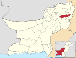
Duki District
This article needs additional citations for verification. (January 2019) |
Duki District
ضلع دوکی دوکي ولسوالۍ دوکی دمگ | |
|---|---|
 Hairan Haiderzai Mound | |
 Map of Balochistan with Duki District highlighted | |
| Country | |
| Province | |
| Division | Loralai |
| Established | 2016 |
| Headquarters | Duki |
| Government | |
| • Type | District Administration |
| • Deputy Commissioner | N/A |
| • District Police Officer | N/A |
| • District Health Officer | N/A |
| Area | |
| • Total | 4,233 km2 (1,634 sq mi) |
| Population (2017) | |
| • Total | 152,977 |
| • Density | 36/km2 (94/sq mi) |
| Time zone | UTC+5 (PKT) |
Duki (Urdu: ضلع دوکی) is a district in the Balochistan province of Pakistan.[1] It is located at an altitude of 1,092 metres (3585 feet) above sea level.[2]
Demographics[edit]
At the time of the 2017 census the district had 21,345 households and a population of 152,977, of which 10,042 (6.56%) lived in urban areas. Duki district had a sex ratio of 865 females per 1000 males and a literacy rate was 28.65% - 40.68% for males and 14.58% for females. 56,255 (36.77%) were under 10 years of age. 206 (0.13%) people in the district were from religious minorities.[3]
At the time of the 2017 census, 85.86% of the population spoke Pashto, 6.41% Balochi, 2.86% Brahui and 1.06% Saraiki as their first language.[3]
References[edit]
- ^ Tehsils & Unions in the District of Loralai - Government Archived March 26, 2012, at the Wayback Machine
- ^ Location of Duki - Falling Rain Genomics
- ^ a b "District-wise census tables". www.pbscensus.gov.pk. Pakistan Bureau of Statistics.
30°9′0″N 68°34′0″E / 30.15000°N 68.56667°E

