
Dyer station
Dyer, IN | |||||||||||||||||
|---|---|---|---|---|---|---|---|---|---|---|---|---|---|---|---|---|---|
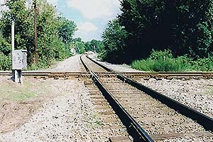
 The old Amtrak shelter station at Dyer before replacement, looking "railroad west" (compass northwest) towards Chicago. | |||||||||||||||||
| General information | |||||||||||||||||
| Location | 913 Sheffield Avenue Dyer, Indiana United States | ||||||||||||||||
| Coordinates | 41°30′55″N 87°31′05″W / 41.5154°N 87.5181°W | ||||||||||||||||
| Line(s) | CSX Monon Subdivision | ||||||||||||||||
| Platforms | 1 side platform | ||||||||||||||||
| Tracks | 1 | ||||||||||||||||
| Construction | |||||||||||||||||
| Accessible | Yes | ||||||||||||||||
| Other information | |||||||||||||||||
| Station code | Amtrak: DYE | ||||||||||||||||
| History | |||||||||||||||||
| Rebuilt | 1986, 2014 | ||||||||||||||||
| Passengers | |||||||||||||||||
| FY 2022 | 959[1] (Amtrak) | ||||||||||||||||
| Services | |||||||||||||||||
| |||||||||||||||||
| |||||||||||||||||
Dyer station is an Amtrak station in Dyer, Indiana, served by the Cardinal route.
Dyer Station was merely a little shelter with seats before a renovation in 2014, which demolished the "Amshack" shelter built in 1986 and constructed a larger station house which was accessible, and repaved the platform and parking lot.[2] It is located north of an at-grade crossing of two railroad lines; CSX (formerly the Monon Railroad) and the Elgin, Joliet & Eastern.[3] The original depot stood at the diamond junction itself.[4]
Connections[edit]
On August 2, 2010, Northwest Indiana Regional Bus Authority revamped the Hammond Transit System into EasyGo Lake Transit. The newly introduced Red Route terminated approximately a mile northeast of the station, at Main/Calumet intersection. Riders could take the Red Route to Munster, Hammond and Chicago's East Side neighborhood. They could also transfer to other EasyGo routes and connect to other towns and cities throughout Lake Country.
Hammond Transit and EasyGo Lake Transit discontinued all service on June 30, 2012.[5]
The Northern Indiana Commuter Transportation District (NICTD) had proposed a line to Lowell, Indiana which ran adjacent to the station, but Dyer's Amtrak station is not a planned stop. The first section of the West Lake Corridor is expected to terminate about 1⁄2 mile (0.8 km) north of the station by 2025.[6][7]
Notes[edit]
- ^ "Amtrak Fact Sheet, Fiscal Year 2022: State of Indiana" (PDF). Amtrak. June 2023. Retrieved August 30, 2023.
- ^ "Dyer, IN (DYE) – Great American Stations". Retrieved 2021-07-10.
- ^ Crossing CSX and EJ&E; August 28, 2001 (TrainWeb)
- ^ Longest (2007), 93.
- ^ "Northwest Indiana Regional Bus Authority: RBA's easygo Service is expanding! Starting August 2!". 2010-06-25. Archived from the original on 2010-08-17.
- ^ "West Lake Corridor Study (NICTD)". Archived from the original on 2009-06-07. Retrieved 2010-03-26.
- ^ "Chapter 2 Alternatives Considered" (PDF). NICTD. Retrieved 18 July 2020.
References[edit]
- Longest, David E. (2007). Railroad Depots of Northern Indiana. Arcadia Publishing. ISBN 978-0-7385-4131-0.
External links[edit]
- Dyer, IN – Amtrak
- Dyer, IN – Station history at Great American Stations (Amtrak)
- Dyer Amtrak Station (USA Rail Guide -- Train Web)
This Indiana train station-related article is a stub. You can help Wikipedia by expanding it. |