Faetano
This article needs additional citations for verification. (February 2024) |
Faetano | |
|---|---|
 Church of San Paolo Apostolo and the town hall (Casa del Castello) in Faetano | |
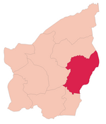
 Faetano's location in San Marino | |
| Coordinates: 43°55′32″N 12°29′54″E / 43.92556°N 12.49833°E | |
| Country | |
| Curazie | List |
| Government | |
| • Capitano | Giorgio Moroni (since 2020) |
| Area | |
| • Total | 7.75 km2 (2.99 sq mi) |
| Elevation | 362 m (1,188 ft) |
| Population (May 2018) | |
| • Total | 1,177[1] |
| Time zone | UTC+1 (CET) |
| • Summer (DST) | CEST |
| Postal code | 47896 |
| Climate | Cfa |
Faetano is one of the nine castelli of San Marino. It has 1,177 inhabitants (May 2018)[1] in an area of 7.75 km2.
Geography[edit]
It borders the Sammarinese municipalities of Montegiardino, Fiorentino, Borgo Maggiore, and Domagnano and the Italian municipalities of Coriano, Montescudo and Sassofeltrio.
Faetano contains four curazie: Cà Chiavello, Calligaria, Corianino, and Monte Pulito.[2][3]
History[edit]
It was attached voluntarily to San Marino in 1463 in the last territorial expansion.
Parishes[edit]
Faetano has four parishes (curazie):
International relations[edit]
Faetano is twinned with:
 Pont-à-Vendin, France(2014) [4]
References[edit]
- ^ a b Popolazionestatistica.sm Archived 1 August 2018 at the Wayback Machine
- ^ Rattini, Maurizio; Venturini, Gian Carlo; Volpinari, Antonio L. (21 March 1997). "Regolamento per la disciplina della campagna elttorale". Elezioni (in Italian). Archived from the original on 5 August 2009. Retrieved 14 February 2020.
- ^ "Borgo Maggiore". San Marino Web (in Italian). Retrieved 9 February 2024.
- ^ "Faetano: firmato il gemellaggio con Pont à Vendin" (in Italian). Retrieved 13 January 2024.
External links[edit]
![]() Media related to Faetano at Wikimedia Commons
Media related to Faetano at Wikimedia Commons
43°55′32″N 12°29′54″E / 43.92556°N 12.49833°E


