
Ferns Nipple
| Ferns Nipple | |
|---|---|
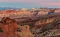
 Ferns Nipple, north aspect | |
| Highest point | |
| Elevation | 7,065 ft (2,153 m)[1] |
| Prominence | 305 ft (93 m)[1] |
| Parent peak | Peak 7100[2] |
| Isolation | 0.96 mi (1.54 km)[2] |
| Coordinates | 38°14′50″N 111°12′48″W / 38.2473396°N 111.2132355°W[3] |
| Geography | |
 Ferns Nipple Location in Utah  Ferns Nipple Ferns Nipple (the United States) | |
| Country | United States |
| State | Utah |
| County | Wayne |
| Protected area | Capitol Reef National Park |
| Parent range | Colorado Plateau |
| Topo map | USGS Golden Throne |
| Geology | |
| Age of rock | Jurassic |
| Type of rock | Navajo Sandstone |
| Climbing | |
| Easiest route | class 4 scrambling[2] |
Ferns Nipple is a 7,065-foot (2,153-meter) elevation summit located in Capitol Reef National Park, in Wayne County of Utah, United States.[3] This iconic landmark is situated 4 mi (6.4 km) southeast of the park's visitor center. Precipitation runoff from this feature is drained by tributaries of the Fremont River, which in turn is within the Colorado River drainage basin. Folklore attributes this geological feature's naming to outlaw Butch Cassidy and his favored girlfriend named Fern.[4]
Climate[edit]
According to the Köppen climate classification system, it is located in a Cold semi-arid climate zone, which is defined by the coldest month having an average mean temperature below 32 °F (0 °C), and at least 50% of the total annual precipitation being received during the spring and summer. This desert climate receives less than 10 inches (250 millimeters) of annual rainfall, and snowfall is generally light during the winter.
Geology[edit]
Ferns Nipple is composed of Navajo Sandstone, which is believed to have formed about 180 million years ago as a giant sand sea, the largest in Earth's history.[5] In a hot, dry climate, wind blew over sand dunes, creating large, sweeping crossbeds which date to the Jurassic. Long after the sedimentary rocks were deposited, the Colorado Plateau was uplifted relatively evenly, keeping the layers roughly horizontal, but Capitol Reef is an exception because of the Waterpocket Fold, a classic monocline, which formed between 50 and 70 million years ago during the Laramide Orogeny.[6]
Gallery[edit]
-
 Ferns Nipple from west
 -
 Ferns Nipple from west
 -
 Ferns Nipple in the distance


See also[edit]
References[edit]
- ^ a b "Ferns Nipple, Utah". Peakbagger.com.
- ^ a b c "Ferns Nipple - 7,065' UT". listsofjohn.com. Retrieved 2020-10-23.
- ^ a b U.S. Geological Survey Geographic Names Information System: Ferns Nipple
- ^ John W. Van Cott, Utah Place Names, University of Utah Press, 1990, page 136.
- ^ Capitol Reef National Park, National Park Service
- ^ Capitol Reef Geology, NPS.gov
External links[edit]
- Capitol Reef National Park National Park Service
- Ferns Nipple: Weather forecast