
File:1956 map of the Kapidag Peninsula (cropped).tif

Size of this JPG preview of this TIF file: 626 × 599 pixels. Other resolutions: 251 × 240 pixels | 501 × 480 pixels | 802 × 768 pixels | 1,070 × 1,024 pixels | 1,336 × 1,279 pixels.
Original file (1,336 × 1,279 pixels, file size: 4.91 MB, MIME type: image/tiff)
| This is a file from the Wikimedia Commons. Information from its description page there is shown below. Commons is a freely licensed media file repository. You can help. |
Summary
| Description |
English: Turkey-Greece, Canakkale, Series: K502, Sheet NK 35-11, 1956, 1:250 000 |
| Date | |
| Source | https://openresearch-repository.anu.edu.au/handle/1885/160269 |
| Author | Prepared by Army Map Service (AMNS), Corps of Engineers, US Army, Washington, D.C. Published by War Office |
| Other versions |

Licensing
This file is a work of a U.S. Army soldier or employee, taken or made as part of that person's official duties. As a work of the U.S. federal government, it is in the public domain in the United States.
|
 |
File history
Click on a date/time to view the file as it appeared at that time.
| Date/Time | Thumbnail | Dimensions | User | Comment | |
|---|---|---|---|---|---|
| current | 21:16, 18 June 2020 | 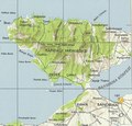 | 1,336 × 1,279 (4.91 MB) | Balkanique | File:Turkey-Greece, Canakkale, Series, K502, Sheet NK 35-11, 1956, 1 to 250 000.tif cropped 84 % horizontally, 81 % vertically using CropTool with precise mode. |
File usage
The following pages on the English Wikipedia use this file (pages on other projects are not listed):
Global file usage
The following other wikis use this file:
- Usage on bg.wikipedia.org
- Usage on tr.wikipedia.org