
File:5 Boroughs New York City Map Julius Schorzman.png
Size of this preview: 616 × 600 pixels. Other resolutions: 247 × 240 pixels | 493 × 480 pixels | 789 × 768 pixels | 1,052 × 1,024 pixels | 2,104 × 2,048 pixels | 2,652 × 2,582 pixels.
Original file (2,652 × 2,582 pixels, file size: 5.47 MB, MIME type: image/png)
| This is a file from the Wikimedia Commons. Information from its description page there is shown below. Commons is a freely licensed media file repository. You can help. |
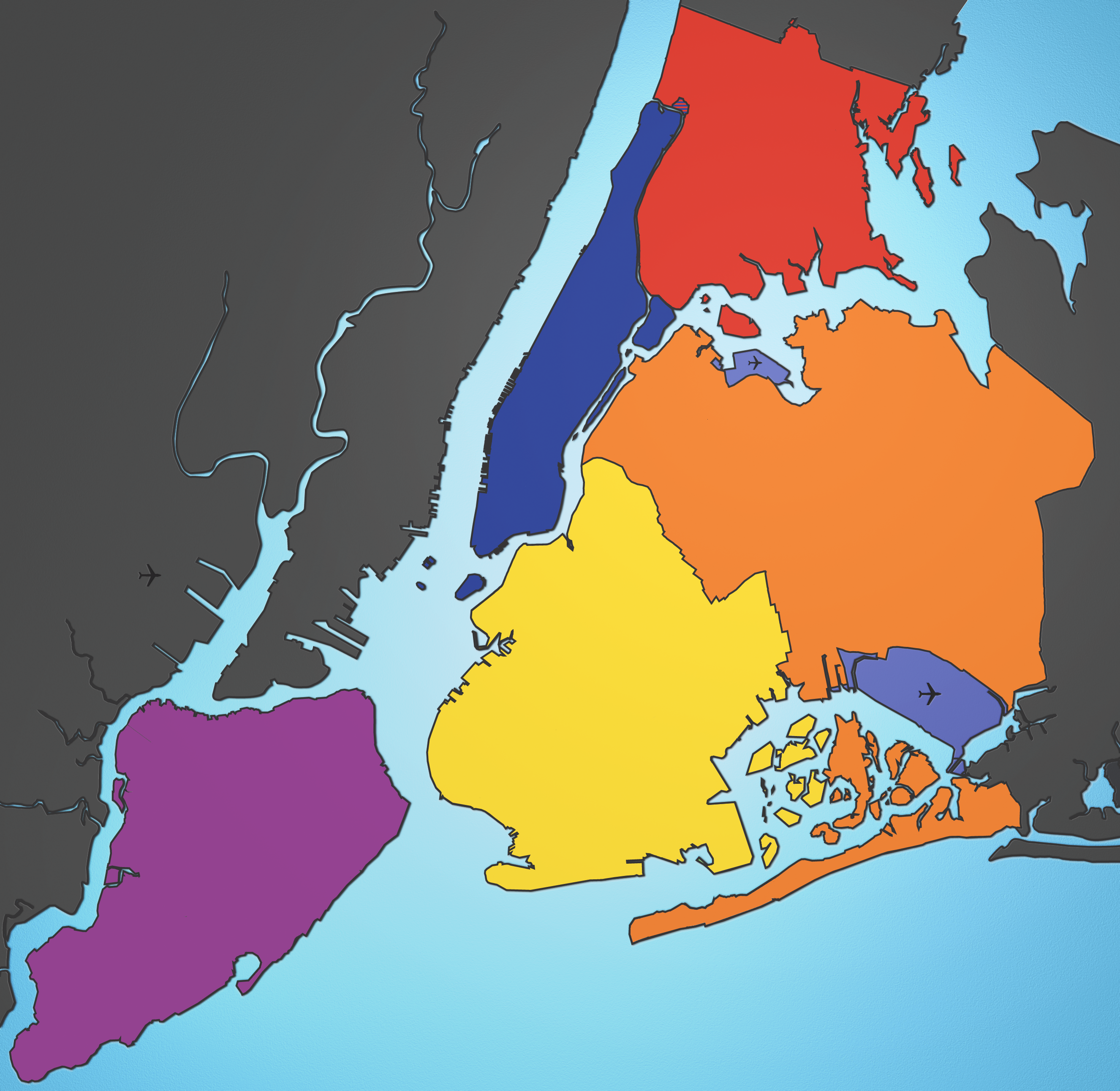
A map showing the five boroughs of New York City, as well as airports.
- Manhattan
- Brooklyn
- Queens
- Bronx
- Staten Island
Airports:
- Nort East: LGA
- Sout East: JFK
- West: EWR
Source: I created this image using various maps and images. Attribution: Julius Schorzman
This file is licensed under the Creative Commons Attribution-Share Alike 2.5 Generic license.
- You are free:
- to share – to copy, distribute and transmit the work
- to remix – to adapt the work
- Under the following conditions:
- attribution – You must give appropriate credit, provide a link to the license, and indicate if changes were made. You may do so in any reasonable manner, but not in any way that suggests the licensor endorses you or your use.
- share alike – If you remix, transform, or build upon the material, you must distribute your contributions under the same or compatible license as the original.
\

|
This locator map image could be re-created using vector graphics as an SVG file. This has several advantages; see Commons:Media for cleanup for more information. If an SVG form of this image is available, please upload it and afterwards replace this template with
{{vector version available|new image name}}.
It is recommended to name the SVG file “5 Boroughs New York City Map Julius Schorzman.svg”—then the template Vector version available (or Vva) does not need the new image name parameter. |
File history
Click on a date/time to view the file as it appeared at that time.
| Date/Time | Thumbnail | Dimensions | User | Comment | |
|---|---|---|---|---|---|
| current | 02:00, 21 April 2007 | | 2,652 × 2,582 (5.47 MB) | Tene~commonswiki | Optimised (3) |
| 02:14, 19 August 2005 |  | 2,652 × 2,582 (6.47 MB) | Quasipalm | A map showing the five boroughs of New York City, as well as airports. <font color="blue">Manhattan</font> <font color="yellow">Brooklyn</font> <font color="orange">Queens</font> <font color="red">Bronx</font> <font color="purple">Staten Island</font> Ai |
File usage
The following pages on the English Wikipedia use this file (pages on other projects are not listed):
- Talk:2019 New York City Marathon
- Talk:2021 New York City Marathon
- Talk:2022 New York City Marathon
- Talk:Brooklyn Gothams
- Talk:Eagle Diamond
- Talk:Flaco (owl)
- Talk:Laboratory for Experimental Medicine and Surgery in Primates
- Talk:Manhattan Savings Institution robbery
- Talk:Oysters in New York City
- Talk:Pershing Square, Manhattan
- Talk:Rose Morat
- Talk:White Cap Marine Towing and Salvage
- Template:WikiProject New York City
- Template:WikiProject New York City/sandbox
Global file usage
The following other wikis use this file:
- Usage on hu.wikipedia.org
- Usage on ro.wikipedia.org
- Usage on ru.wikipedia.org