
File:Closer-in interior view of N room of mill, looking NW, showing cast-iron columns and arches. - Hacienda Azurarera Santa Elena, Sugar Mill Ruins, 1.44 miles North of PR Route 2 HAER PR,75-TOBA,1A-31.tif

Size of this JPG preview of this TIF file: 430 × 599 pixels. Other resolutions: 172 × 240 pixels | 344 × 480 pixels | 551 × 768 pixels | 734 × 1,024 pixels | 1,469 × 2,048 pixels | 3,587 × 5,000 pixels.
Original file (3,587 × 5,000 pixels, file size: 17.11 MB, MIME type: image/tiff)
| This is a file from the Wikimedia Commons. Information from its description page there is shown below. Commons is a freely licensed media file repository. You can help. |
Summary
| Closer-in interior view of N room of mill, looking NW, showing cast-iron columns and arches. - Hacienda Azurarera Santa Elena, Sugar Mill Ruins, 1.44 miles North of PR Route 2 Bridge Over Rio De La Plata, Toa Baja, Toa Baja Municipio, PR | ||||
|---|---|---|---|---|
| Title |
Closer-in interior view of N room of mill, looking NW, showing cast-iron columns and arches. - Hacienda Azurarera Santa Elena, Sugar Mill Ruins, 1.44 miles North of PR Route 2 Bridge Over Rio De La Plata, Toa Baja, Toa Baja Municipio, PR |
|||
| Description |
Feduchi , Juan Rijus; Figueras; Fonalledas, Jamie; Mirrlees and Watson; Fonalledas, Geronimo; Cary, Brian, transmitter; Conservation Trust of Puerto Rico, sponsor; Institute of Mechanical Engineers of Puerto Rico, sponsor; Griffin, Douglas L, project manager; Delony, Eric, project manager; Blanco, Francisco Javier, field team; Yearby, Jean P, transmitter; Egbert, Charles P, D, delineator; Nistal-Moret, Benjamin, historian; Valle, Reinhard A, delineator; Fraga, Robert, delineator; Howard, Richard A, delineator; Sanchez-Sanchez, Hector, historian; Boucher, Jack, photographer; Melendez, Javier, historian |
|||
| Depicted place | Puerto Rico; Toa Baja Municipio; Toa Baja | |||
| Date | Documentation compiled after 1968 | |||
| Dimensions | 5 x 7 in. | |||
| Current location |
Library of Congress Prints and Photographs Division Washington, D.C. 20540 USA http://hdl.loc.gov/loc.pnp/pp.print |
|||
| Accession number |
HAER PR,75-TOBA,1A-31 |
|||
| Credit line |
|
|||
| Notes |
|
|||
| Source | https://www.loc.gov/pictures/item/pr0023.photos.144047p | |||
| Permission (Reusing this file) |
|
|||

| Object location | | View this and other nearby images on: OpenStreetMap |
|---|
File history
Click on a date/time to view the file as it appeared at that time.
| Date/Time | Thumbnail | Dimensions | User | Comment | |
|---|---|---|---|---|---|
| current | 09:49, 1 August 2014 | 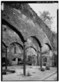 | 3,587 × 5,000 (17.11 MB) | Fæ | GWToolset: Creating mediafile for Fæ. HABS 31 July 2014 (3000:3200) |
File usage
The following pages on the English Wikipedia use this file (pages on other projects are not listed):