
File:Construction view of concrete bridge meeting railroad bridge, 10-28-37 (Matlack 247-13). - Seven Mile Bridge, Linking Florida Keys, Marathon, Monroe County, FL HAER FLA,44-KNIKE,1-62.tif

Size of this JPG preview of this TIF file: 750 × 600 pixels. Other resolutions: 300 × 240 pixels | 600 × 480 pixels | 960 × 768 pixels | 1,280 × 1,024 pixels | 2,560 × 2,048 pixels | 4,966 × 3,972 pixels.
Original file (4,966 × 3,972 pixels, file size: 18.81 MB, MIME type: image/tiff)
| This is a file from the Wikimedia Commons. Information from its description page there is shown below. Commons is a freely licensed media file repository. You can help. |
Summary
| Construction view of concrete bridge meeting railroad bridge, 10-28-37 (Matlack 247-13). - Seven Mile Bridge, Linking Florida Keys, Marathon, Monroe County, FL | ||||
|---|---|---|---|---|
| Photographer |
Related names:
|
|||
| Title |
Construction view of concrete bridge meeting railroad bridge, 10-28-37 (Matlack 247-13). - Seven Mile Bridge, Linking Florida Keys, Marathon, Monroe County, FL |
|||
| Depicted place | Florida; Monroe County; Marathon | |||
| Date | Documentation compiled after 1968 | |||
| Dimensions | 4 x 5 in. | |||
| Current location |
Library of Congress Prints and Photographs Division Washington, D.C. 20540 USA http://hdl.loc.gov/loc.pnp/pp.print |
|||
| Accession number |
HAER FLA,44-KNIKE,1-62 |
|||
| Credit line |
|
|||
| Notes |
|
|||
| Source | https://www.loc.gov/pictures/item/fl0293.photos.053086p | |||
| Permission (Reusing this file) |
|
|||

| Object location | | View this and other nearby images on: OpenStreetMap |
|---|
File history
Click on a date/time to view the file as it appeared at that time.
| Date/Time | Thumbnail | Dimensions | User | Comment | |
|---|---|---|---|---|---|
| current | 22:18, 11 July 2014 | 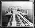 | 4,966 × 3,972 (18.81 MB) | Fæ | GWToolset: Creating mediafile for Fæ. HABS 09 July 2014 (801:1000) |
File usage
The following pages on the English Wikipedia use this file (pages on other projects are not listed):