
File:FRONT PORCH LOOKING NORTHWEST SHOWING FRONT DOOR AND WINDOWS - Ketch Ranch, Medicine Park, Comanche County, OK HABS OK-66-9.tif

Size of this JPG preview of this TIF file: 737 × 599 pixels. Other resolutions: 295 × 240 pixels | 590 × 480 pixels | 945 × 768 pixels | 1,259 × 1,024 pixels | 2,518 × 2,048 pixels | 5,354 × 4,354 pixels.
Original file (5,354 × 4,354 pixels, file size: 22.23 MB, MIME type: image/tiff)
| This is a file from the Wikimedia Commons. Information from its description page there is shown below. Commons is a freely licensed media file repository. You can help. |
Summary
| FRONT PORCH LOOKING NORTHWEST SHOWING FRONT DOOR AND WINDOWS - Ketch Ranch, Medicine Park, Comanche County, OK | ||||
|---|---|---|---|---|
| Photographer |
McGrath, Timothy Image West Photography. Related names:
|
|||
| Title |
FRONT PORCH LOOKING NORTHWEST SHOWING FRONT DOOR AND WINDOWS - Ketch Ranch, Medicine Park, Comanche County, OK |
|||
| Depicted place | Oklahoma; Comanche County; Medicine Park | |||
| Date | 2008 | |||
| Dimensions | 4 x 5 in. | |||
| Current location |
Library of Congress Prints and Photographs Division Washington, D.C. 20540 USA http://hdl.loc.gov/loc.pnp/pp.print |
|||
| Accession number |
HABS OK-66-9 |
|||
| Credit line |
|
|||
| Notes |
|
|||
| Source | https://www.loc.gov/pictures/item/ok0083.photos.363511p | |||
| Permission (Reusing this file) |
|
|||

| Object location | | View this and other nearby images on: OpenStreetMap |
|---|
File history
Click on a date/time to view the file as it appeared at that time.
| Date/Time | Thumbnail | Dimensions | User | Comment | |
|---|---|---|---|---|---|
| current | 03:19, 2 August 2014 | 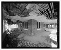 | 5,354 × 4,354 (22.23 MB) | Fæ | GWToolset: Creating mediafile for Fæ. HABS 2014-08-01 2601-2900 missing |
File usage
The following pages on the English Wikipedia use this file (pages on other projects are not listed):