
File:GENERAL VIEW FROM MAIN STREET OVERPASS SHOWING THE INCLINED RAILROAD, STILL IN USE AS OF 1974 - Madison and Indianapolis Railroad, Madison Incline, West Main Street, Madison, HAER IND,39-MAD,45A-2.tif

Size of this JPG preview of this TIF file: 434 × 600 pixels. Other resolutions: 174 × 240 pixels | 347 × 480 pixels | 556 × 768 pixels | 741 × 1,024 pixels | 1,482 × 2,048 pixels | 3,618 × 5,000 pixels.
Original file (3,618 × 5,000 pixels, file size: 17.25 MB, MIME type: image/tiff)
| This is a file from the Wikimedia Commons. Information from its description page there is shown below. Commons is a freely licensed media file repository. You can help. |
Summary
| GENERAL VIEW FROM MAIN STREET OVERPASS SHOWING THE INCLINED RAILROAD, STILL IN USE AS OF 1974 - Madison and Indianapolis Railroad, Madison Incline, West Main Street, Madison, Jefferson County, IN | ||||
|---|---|---|---|---|
| Title |
GENERAL VIEW FROM MAIN STREET OVERPASS SHOWING THE INCLINED RAILROAD, STILL IN USE AS OF 1974 - Madison and Indianapolis Railroad, Madison Incline, West Main Street, Madison, Jefferson County, IN |
|||
| Description |
Boucher, Jack E |
|||
| Depicted place | Indiana; Jefferson County; Madison | |||
| Date | Documentation compiled after 1968 | |||
| Dimensions | 5 x 7 in. | |||
| Current location |
Library of Congress Prints and Photographs Division Washington, D.C. 20540 USA http://hdl.loc.gov/loc.pnp/pp.print |
|||
| Accession number |
HAER IND,39-MAD,45A-2 |
|||
| Credit line |
|
|||
| Notes |
|
|||
| Source | https://www.loc.gov/pictures/item/in0101.photos.064834p | |||
| Permission (Reusing this file) |
|
|||

| Camera location | | View this and other nearby images on: OpenStreetMap |
|---|
File history
Click on a date/time to view the file as it appeared at that time.
| Date/Time | Thumbnail | Dimensions | User | Comment | |
|---|---|---|---|---|---|
| current | 02:08, 18 July 2014 | 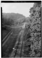 | 3,618 × 5,000 (17.25 MB) | Fæ | GWToolset: Creating mediafile for Fæ. HABS 16 July 2014 (1201:1400) |
File usage
The following pages on the English Wikipedia use this file (pages on other projects are not listed):