
File:GENERAL VIEW OF THE EAST NAVIDAD RIVER BRIDGE, SOUTH SIDE, LOOKING NORTHWEST. - East Navidad River Bridge, Spanning East Navidad River at FM1579, Schulenburg, Fayette County, TX HAER TX,75-SCHU.V,1-2.tif

Size of this JPG preview of this TIF file: 757 × 600 pixels. Other resolutions: 303 × 240 pixels | 606 × 480 pixels | 969 × 768 pixels | 1,280 × 1,015 pixels | 2,560 × 2,029 pixels | 5,000 × 3,963 pixels.
Original file (5,000 × 3,963 pixels, file size: 18.9 MB, MIME type: image/tiff)
| This is a file from the Wikimedia Commons. Information from its description page there is shown below. Commons is a freely licensed media file repository. You can help. |
Summary
| GENERAL VIEW OF THE EAST NAVIDAD RIVER BRIDGE, SOUTH SIDE, LOOKING NORTHWEST. - East Navidad River Bridge, Spanning East Navidad River at FM1579, Schulenburg, Fayette County, TX | ||||
|---|---|---|---|---|
| Photographer |
Harms, Bruce, creator |
|||
| Title |
GENERAL VIEW OF THE EAST NAVIDAD RIVER BRIDGE, SOUTH SIDE, LOOKING NORTHWEST. - East Navidad River Bridge, Spanning East Navidad River at FM1579, Schulenburg, Fayette County, TX |
|||
| Description |
Granger, A T; Robertson, Lake; Texas Department of TRansportation, sponsor; Texas Historical Commission, sponsor; Hardman, Peggy, historian; Harms, Bruce A, photographer |
|||
| Depicted place | Texas; Fayette County; Schulenburg | |||
| Date | 2001 | |||
| Dimensions | 4 x 5 in. | |||
| Current location |
Library of Congress Prints and Photographs Division Washington, D.C. 20540 USA http://hdl.loc.gov/loc.pnp/pp.print |
|||
| Accession number |
HAER TX,75-SCHU.V,1-2 |
|||
| Credit line |
|
|||
| Notes |
|
|||
| Source | https://www.loc.gov/pictures/item/tx0947.photos.366959p | |||
| Permission (Reusing this file) |
|
|||

|
This is an image of a place or building that is listed on the National Register of Historic Places in the United States of America. Its reference number is 14000497. |
File history
Click on a date/time to view the file as it appeared at that time.
| Date/Time | Thumbnail | Dimensions | User | Comment | |
|---|---|---|---|---|---|
| current | 09:50, 2 August 2014 | 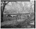 | 5,000 × 3,963 (18.9 MB) | Fæ | GWToolset: Creating mediafile for Fæ. HABS 2014-08-01 (3201:3400) |
File usage
The following pages on the English Wikipedia use this file (pages on other projects are not listed):
Global file usage
The following other wikis use this file:
- Usage on www.wikidata.org