
File:General view to south, from Orphan Street. - Larimer Avenue Bridge, Spanning Washington Boulevard at Larimer Avenue (State Route 8), Pittsburgh, Allegheny County, PA HAER PA,2-PITBU,73-1.tif

Size of this JPG preview of this TIF file: 800 × 577 pixels. Other resolutions: 320 × 231 pixels | 640 × 461 pixels | 1,024 × 738 pixels | 1,280 × 923 pixels | 2,560 × 1,846 pixels | 5,000 × 3,605 pixels.
Original file (5,000 × 3,605 pixels, file size: 17.19 MB, MIME type: image/tiff)
| This is a file from the Wikimedia Commons. Information from its description page there is shown below. Commons is a freely licensed media file repository. You can help. |
Summary
| General view to south, from Orphan Street. - Larimer Avenue Bridge, Spanning Washington Boulevard at Larimer Avenue (State Route 8), Pittsburgh, Allegheny County, PA | ||||
|---|---|---|---|---|
| Photographer |
Lowe, Jet, creator |
|||
| Title |
General view to south, from Orphan Street. - Larimer Avenue Bridge, Spanning Washington Boulevard at Larimer Avenue (State Route 8), Pittsburgh, Allegheny County, PA |
|||
| Description |
Ferguson, John A; John F. Casey Company; Pittsburgh Department of Public Works; Sprague, Norman S; McAlister, Charles H; Stange, Ottomar; Roush, Stanley L; Armstrong, Joseph G; Wilkerson, T J; Magee, William A; DeLony, Eric N, project manager; Pennsylvania Department of Transportation, sponsor; Pennsylvania Historical and Museum Commission, sponsor; Hawley, Haven, historian; Lowe, Jet, photographer |
|||
| Depicted place | Pennsylvania; Allegheny County; Pittsburgh | |||
| Date | 1999 | |||
| Dimensions | 5 x 7 in. | |||
| Current location |
Library of Congress Prints and Photographs Division Washington, D.C. 20540 USA http://hdl.loc.gov/loc.pnp/pp.print |
|||
| Accession number |
HAER PA,2-PITBU,73-1 |
|||
| Credit line |
|
|||
| Notes |
|
|||
| Source | https://www.loc.gov/pictures/item/pa3657.photos.361474p | |||
| Permission (Reusing this file) |
|
|||

File history
Click on a date/time to view the file as it appeared at that time.
| Date/Time | Thumbnail | Dimensions | User | Comment | |
|---|---|---|---|---|---|
| current | 05:06, 1 August 2014 | 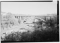 | 5,000 × 3,605 (17.19 MB) | Fæ | GWToolset: Creating mediafile for Fæ. HABS 31 July 2014 (3000:3200) |
File usage
The following pages on the English Wikipedia use this file (pages on other projects are not listed):