
File:Lincoln Home Site, Site Plan, Eighth Street, Springfield, Sangamon County, IL HABS ILL,84-SPRIF,2- (sheet 1 of 1).tif

Size of this JPG preview of this TIF file: 800 × 531 pixels. Other resolutions: 320 × 213 pixels | 640 × 425 pixels | 1,024 × 680 pixels | 1,280 × 850 pixels | 2,560 × 1,701 pixels | 14,500 × 9,632 pixels.
Original file (14,500 × 9,632 pixels, file size: 1.22 MB, MIME type: image/tiff)
| This is a file from the Wikimedia Commons. Information from its description page there is shown below. Commons is a freely licensed media file repository. You can help. |
Summary
| Warning | The original file is very high-resolution. It might not load properly or could cause your browser to freeze when opened at full size. |
|---|
| HABS ILL,84-SPRIF,2- (sheet 1 of 1) - Lincoln Home Site, Site Plan, Eighth Street, Springfield, Sangamon County, IL | ||||
|---|---|---|---|---|
| Title |
HABS ILL,84-SPRIF,2- (sheet 1 of 1) - Lincoln Home Site, Site Plan, Eighth Street, Springfield, Sangamon County, IL |
|||
| Depicted place | Illinois; Sangamon County; Springfield | |||
| Date | Documentation compiled after 1933 | |||
| Dimensions | 24 x 36 in. (D size) | |||
| Current location |
Library of Congress Prints and Photographs Division Washington, D.C. 20540 USA http://hdl.loc.gov/loc.pnp/pp.print |
|||
| Accession number |
HABS ILL,84-SPRIF,2- (sheet 1 of 1) |
|||
| Credit line |
|
|||
| Notes |
|
|||
| References |
|
|||
| Source | https://www.loc.gov/pictures/item/il0382.sheet.00001a | |||
| Permission (Reusing this file) |
|
|||
| Other versions |
.png) |
|||

| Object location | | View this and other nearby images on: OpenStreetMap |
|---|
File history
Click on a date/time to view the file as it appeared at that time.
| Date/Time | Thumbnail | Dimensions | User | Comment | |
|---|---|---|---|---|---|
| current | 22:38, 16 July 2014 | 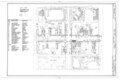 | 14,500 × 9,632 (1.22 MB) | Fæ | GWToolset: Creating mediafile for Fæ. HABS 11 July 2014 (1001:1200) |
File usage
The following pages on the English Wikipedia use this file (pages on other projects are not listed):
Global file usage
The following other wikis use this file:
- Usage on bn.wikipedia.org
- Usage on ha.wikipedia.org