
File:MAP&LIST of the General location of the Japanese POW Laborers’ camps in the Soviet Union and in Outer Mongolia around 1946.pdf

Original file (2,550 × 1,650 pixels, file size: 6.89 MB, MIME type: application/pdf)
| This is a file from the Wikimedia Commons. Information from its description page there is shown below. Commons is a freely licensed media file repository. You can help. |
Summary
| Description |
English: LEGEND:
NOTE 1. ○Large Circles with heavy outline (numbered in red): Over 20,000 detained. ●Black circles (numbered in blue): Over 10,000. ○White, small circles (numbered in black): Less than 10,000. △Triangles (numbered in Green): Small number. NOTE 2. The above-designated graphic symbols show the principal area of the labor camp location. Created by combining two maps, published by the former Ministry of Health and Welfare and the current Ministry of Labor, Health and Welfare of the Japanese Government: 1)Kôseishô engokyoku [Bureau of Assistance, Ministry of Health and Welfare]. Hikiage to engo sanjûnen no ayumi [Thirty-year progress of the repatriation and assistance]. Kôseishô. 1977. P56. 2)Kôseishô shakai/engokyoku engo gojûnenshi henshû iinkai [Editorial Committee of Fifty-year history of assistance. Bureau of Social/Assistance, Ministry of Health and Welfare]. Engo gojûnenshi [Fifty-year history of assistance]. Gyôsei. 1997. pp524-525. Location names, listed originally in katakana-Japanese, have been transcribed into English using five maps published in the United States, United Kingdom, and USSR. A)Union of Soviet Socialist Republic. Compiled and drawn in the Cartographic Section of the National Geographic Society for the National Geographic Magazine. Grovesnor, Gilbert. Ed. Washington. U.S.A. 1944. B)U.S.S.R.and Adjacent Areas 1:8,000,000. Published by Department of Survey, Ministry of Defense, United Kingdom. British Crown Copyright Reserved Series 5104. U.K. 1964. C)USSR Railways. J.R. Yonge. The Quail Map Company. Exeter. U. K. 1973. D)USSR Railways. J.R. Yonge. The Quail Map Company. Exeter. U.K. 1976. E)Soviet Union. Produced by the Cartographic Division. National Geographic Society. National Geographic Magazine. Grovesnor, Melville B. Ed. Washington. U.S.A. 1976. F)Union of Soviet Socialist Republic. Moscow News Supplement. Main Administration of Geodesy and Cartography under the Council of Minister of the USSR. U.S.S.R. 1979. |
| Date | |
| Source | Own work |
| Author | Sey Nishimura |
Licensing
- You are free:
- to share – to copy, distribute and transmit the work
- to remix – to adapt the work
- Under the following conditions:
- attribution – You must give appropriate credit, provide a link to the license, and indicate if changes were made. You may do so in any reasonable manner, but not in any way that suggests the licensor endorses you or your use.
- share alike – If you remix, transform, or build upon the material, you must distribute your contributions under the same or compatible license as the original.
File history
Click on a date/time to view the file as it appeared at that time.
| Date/Time | Thumbnail | Dimensions | User | Comment | |
|---|---|---|---|---|---|
| current | 16:51, 19 August 2017 | 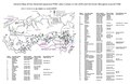 | 2,550 × 1,650 (6.89 MB) | Seynishim | User created page with UploadWizard |
File usage
Global file usage
The following other wikis use this file:
- Usage on az.wikipedia.org
- Usage on pt.wikipedia.org
- Usage on ro.wikipedia.org
- Usage on tr.wikipedia.org