
File:Pakistan Railways Network.png
Size of this preview: 615 × 599 pixels. Other resolutions: 246 × 240 pixels | 493 × 480 pixels | 788 × 768 pixels | 1,051 × 1,024 pixels | 2,248 × 2,191 pixels.
Original file (2,248 × 2,191 pixels, file size: 500 KB, MIME type: image/png)
| This is a file from the Wikimedia Commons. Information from its description page there is shown below. Commons is a freely licensed media file repository. You can help. |
Summary
| Description |
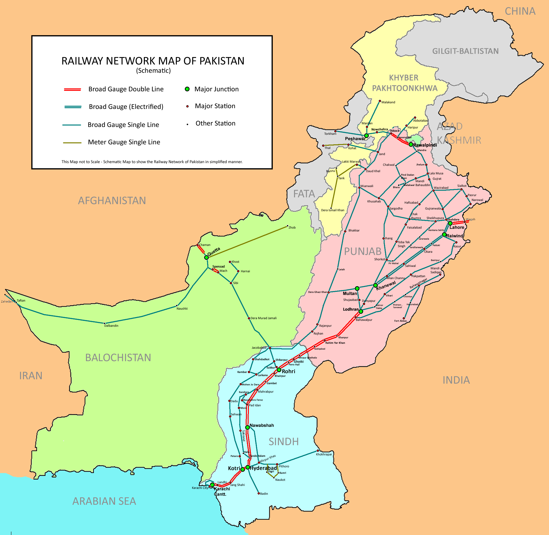
English: Railway Network of Pakistan - Schematic. (Abbreviation used in this map: FATA: Federally Administered Tribal Areas.) |
| Date | Uploaded in June 2009 by Nomi887; modified in July 2009 by Brainlara73. |
| Source | The English language Wikipedia. Original text: Self made using [1] and [2] as reference. |
| Author | Original text: nomi887 (talk) |
![[2]](https://upload.wikimedia.org/wikipedia/en/d/d1/Punjabadmin.jpg)
Licensing
This file is licensed under the Creative Commons Attribution-Share Alike 3.0 Unported license.
Attribution: Nomi887
- You are free:
- to share – to copy, distribute and transmit the work
- to remix – to adapt the work
- Under the following conditions:
- attribution – You must give appropriate credit, provide a link to the license, and indicate if changes were made. You may do so in any reasonable manner, but not in any way that suggests the licensor endorses you or your use.
- share alike – If you remix, transform, or build upon the material, you must distribute your contributions under the same or compatible license as the original.
Original upload log
All usernames refer to en:Wikipedia (log):
- 10:42, 7 July 2009 Brainlara73 uploaded a new version of "File:Pakistan Railways Network.png" 2,248×2,191 (425 KB) (Added some more Railway stations)
- 03:49, 30 June 2009 Nomi887 uploaded a new version of "File:Pakistan Railways Network.png" 2,248×2,191 (425 KB) (Added some missing stations in Sindh.)
- 13:02, 29 June 2009 Nomi887 uploaded "File:Pakistan Railways Network.png" 2,248×2,191 (480 KB) ({{Information |Description = Railway Network of Pakistan - Schematic |Source = Self made using http://pakrail.com/map.asp and http://upload.wikimedia.org/wikipedia/en/d/d1/Punjabadmin.jpg as reference. |Date = |Author = ~)
File history
Click on a date/time to view the file as it appeared at that time.
| Date/Time | Thumbnail | Dimensions | User | Comment | |
|---|---|---|---|---|---|
| current | 12:30, 21 March 2011 | | 2,248 × 2,191 (500 KB) | Nomi887 | Added more stations in Sindh & Punjab |
| 07:53, 17 August 2010 |  | 2,248 × 2,191 (486 KB) | Nomi887 | Added some stations. | |
| 11:24, 9 July 2010 |  | 2,248 × 2,191 (483 KB) | Nomi887 | Corrected names of some provinces & some general corrections. | |
| 23:47, 6 January 2010 |  | 2,248 × 2,191 (425 KB) | Guillaume70 | {{Information |Description= Railway Network of Pakistan - Schematic. (Abbreviations used in this map: 1. NWFP: North West Frontier Province, 2. FATA: Federally Administered Tribal Areas.) |Source=Wikipedia en |Date= |Author=[http://en.wikipedia.org/wiki/U |
File usage
The following pages on the English Wikipedia use this file (pages on other projects are not listed):
Global file usage
The following other wikis use this file:
- Usage on zh.wikipedia.org