
File:VIEW OF ORIGINAL JUMPING TOWER AND SPRING BOARDS - Fleischhacker Pool and Bath House, Sloat Boulevard and Great Highway, San Francisco, San Francisco County, CA HABS CAL,38-SANFRA,136-20.tif

Size of this JPG preview of this TIF file: 751 × 599 pixels. Other resolutions: 301 × 240 pixels | 602 × 480 pixels | 963 × 768 pixels | 1,280 × 1,021 pixels | 2,560 × 2,043 pixels | 5,000 × 3,990 pixels.
Original file (5,000 × 3,990 pixels, file size: 19.03 MB, MIME type: image/tiff)
| This is a file from the Wikimedia Commons. Information from its description page there is shown below. Commons is a freely licensed media file repository. You can help. |
Summary
| VIEW OF ORIGINAL JUMPING TOWER AND SPRING BOARDS - Fleischhacker Pool and Bath House, Sloat Boulevard and Great Highway, San Francisco, San Francisco County, CA | ||||
|---|---|---|---|---|
| Title |
VIEW OF ORIGINAL JUMPING TOWER AND SPRING BOARDS - Fleischhacker Pool and Bath House, Sloat Boulevard and Great Highway, San Francisco, San Francisco County, CA |
|||
| Description |
This is an undated historic photo, during 1925 to 1971 when the pool was open. Photo collected from the San Francisco Room of the San Francisco public library around 1979 by Historic American Buildings Survey) study of HABS site CA-2075, which was documented in 1979. HABS Index to photos of [https://www.loc.gov/item/ca0642/ HABS study of the Fleischhacker Pool and Bath House (July 1980) |
|||
| Depicted place | California; San Francisco County; San Francisco | |||
| Dimensions | 4 x 5 in. | |||
| Current location |
Library of Congress Prints and Photographs Division Washington, D.C. 20540 USA http://hdl.loc.gov/loc.pnp/pp.print |
|||
| Accession number |
HABS CAL,38-SANFRA,136-20 |
|||
| Credit line |
|
|||
| Source | https://www.loc.gov/pictures/item/ca0642.photos.016227p | |||
| Permission (Reusing this file) |
|
|||

| Camera location | | View this and other nearby images on: OpenStreetMap |
|---|
File history
Click on a date/time to view the file as it appeared at that time.
| Date/Time | Thumbnail | Dimensions | User | Comment | |
|---|---|---|---|---|---|
| current | 21:10, 3 July 2014 | 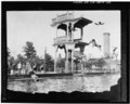 | 5,000 × 3,990 (19.03 MB) | Fæ | GWToolset: Creating mediafile for Fæ. HABS 3 July 2014 (201:300) |
File usage
The following pages on the English Wikipedia use this file (pages on other projects are not listed):