
Grimersum
Grimersum | |
|---|---|
 Aerial view of Grimersum | |
 Coat of arms | |
Location of Grimersum  | |
 Grimersum  Grimersum | |
| Coordinates: 53°28′38″N 7°10′14″E / 53.47709°N 7.17051°E | |
| Country | Germany |
| State | Lower Saxony |
| District | Aurich |
| Municipality | Krummhörn |
| Area | |
| • Metro | 16.13 km2 (6.23 sq mi) |
| Elevation | 3.8 m (12.5 ft) |
| Population | |
| • Metro | 577 |
| Time zone | UTC+01:00 (CET) |
| • Summer (DST) | UTC+02:00 (CEST) |
| Postal codes | 26736 |
| Dialling codes | 04920 |
Grimersum is a village in the region of East Frisia, in Lower Saxony, Germany. It is part of the municipality of Krummhörn. The village is located in between Eilsum and Wirdum, about 12.5 kilometers north of Emden.
The village, like nearby Groothusen, is one of the elongated warft villages that were built in the early 8th century on estuaries and bends as trading places for the expanding overseas trade of the Frisian peasant merchants.[1] The village is dominated by an old church, which was built in the 13th century.[2]
Gallery[edit]
-
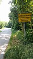 Entrance to Grimersum
 -
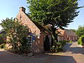 Worker's house
 -
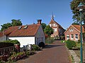 View of the Church of Grimersum


Notable people[edit]
- Eggerik Beninga (1490–1562), chronicler
- Johannes Acronius (1565–1627), theologian
References[edit]
- ^ "Grimersum". Wierden en terpen (in Dutch). Retrieved 19 March 2024.
- ^ "Evangelisch-Reformierte Kirche Grimersum" [Evangelical Reformed Church Grimersum]. Ostfriesland (in German). Retrieved 19 March 2019.
External links[edit]
![]() Media related to Grimersum at Wikimedia Commons
Media related to Grimersum at Wikimedia Commons
Villages in the municipality of Krummhörn | ||
|---|---|---|
This German location article is a stub. You can help Wikipedia by expanding it. |