
Hassamu-Minami Station
T02 Hassamu-Minami Station 発寒南駅 | |||||||||||
|---|---|---|---|---|---|---|---|---|---|---|---|
 Station exit | |||||||||||
| General information | |||||||||||
| Location | Nishi, Sapporo, Hokkaido Japan | ||||||||||
| Operated by | Sapporo City Transportation Bureau | ||||||||||
| Line(s) | |||||||||||
| Construction | |||||||||||
| Accessible | Yes | ||||||||||
| Other information | |||||||||||
| Station code | T02 | ||||||||||
| History | |||||||||||
| Opened | February 25, 1999 | ||||||||||
| Services | |||||||||||
| |||||||||||
| Location | |||||||||||
 T02 Hassamu-Minami Station Location within Hokkaido  T02 Hassamu-Minami Station T02 Hassamu-Minami Station (Japan) | |||||||||||
Hassamu-Minami Station (発寒南駅) is a Sapporo Municipal Subway station in Nishi-ku, Sapporo, Hokkaido, Japan. The station number is T02.
Platforms[edit]
| 1 | ■ Tōzai Line | for Shin-Sapporo |
| 2 | ■ Tōzai Line | for Miyanosawa |
History[edit]
The station opened on 25 February 1999 coinciding with the opening of the Tozai Line extension from Kotoni Station to Miyanosawa Station.[1]
Surrounding area[edit]
- Hassamu-Chūō Station, JR Hokkaido
- Hassamu-Minami city bus terminal
- Nishimachi-west Police station
- Sapporo-Kita Post Office
- Maxvalu supermarket, Express Hassamu-Minami station store
- Seiyu Supermarket, West branch
- Sapporo City Agricultural Cooperative Association (JA Sapporo), West branch
- North Pacific Bank, West Branch
- Sapporo Shinkin Bank, Tsukisamu branch
- Rumoi Shinkin Bank, Sapporo Branch
Gallery[edit]
-
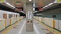 Platforms 1 and 2
 -
 Station signboard

References[edit]
- ^ "地下鉄(高速電車)の概要" [Overview of the subway (high-speed train)]. city.sapporo.jp (in Japanese). Archived from the original on 19 January 2024. Retrieved 6 February 2024.
External links[edit]
Wikimedia Commons has media related to Hassamu-Minami Station.
Stations of the Sapporo Municipal Subway Tōzai Line | ||
|---|---|---|
43°4′55.419″N 141°17′21.71″E / 43.08206083°N 141.2893639°E
This Hokkaido rail station-related article is a stub. You can help Wikipedia by expanding it. |