
Jagal, Pakistan
Jagal
جاگل | |
|---|---|
Village | |
 Jagal Location in Punjab, Pakistan | |
| Coordinates: 32°49′45″N 74°08′04″E / 32.82917°N 74.13444°E | |
| Country | |
| Province | Punjab |
| Region/Division | Gujrat |
| District | Gujrat |
| Tehsil | Kharian |
| Union Council | Dilawar-Pur |
| Time zone | UTC+5 (PST) |
| Postal Code | 50991 |
| Area code | 053 |
Jagal (Urdu: جاگل) is a village in District Gujrat, in Punjab, Pakistan, situated about 6 kilometres (4 mi) east of Kotla Arab Ali Khan. The village is 38 kilometres (24 mi) from Gujrat city and about 30 kilometres (19 mi) from Kharian city. The union council of Jagal is Dilawarpur which is 2 kilometres (1 mi) to the east. The border of Azad Kashmir lies approximately 10 kilometres (6.2 mi) north of the village. The word Jagal comes from subcast of Gujjar. They are the people who started to live here more or less in 15th century
Picture gallery[edit]
-
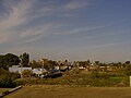
 view from Jagal
 -
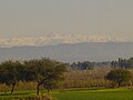
 hills View
 -
 Road under construction
 -
 Jagal view


Wikimedia Commons has media related to Jagal (village).
This article about a location in Gujrat District, Punjab, Pakistan is a stub. You can help Wikipedia by expanding it. |