
Kahaluʻu Taro Loʻi
Kahaluʻu Taro Loʻi Historic District | |
 Terrace walls overgrown by hau trees | |
 | |
| Nearest city | W of western end of Hui Kelu St., Kāneʻohe, Hawaiʻi |
|---|---|
| Coordinates | 21°25′47″N 157°50′31″W / 21.42972°N 157.84194°W |
| Area | 22 acres (8.9 ha) |
| NRHP reference No. | 73000669[1] |
| Added to NRHP | March 14, 1973 |
The Kahaluʻu Taro Loʻi Historic District, also known as the ʻĀhuimanu Taro Complex, in Kahaluʻu on the windward side of Oʻahu, is the most complex and largest intact system of terraces for growing wetland taro on Oʻahu. It contains at least 18 loʻi (pondfield) terraces once watered by ʻĀhuimanu Stream and associated ʻauwai (irrigation ditches) over about 25 acres (100,000 m2) that start from headwaters just below the cliffs of the Koʻolau Range. It was added to the National Register of Historic Places in 1973,[2] after windward residents raised concerns about development plans in the area.[3] The Kahaluu Fish Pond was also added to the National Register at that time.
The terraces are roughly rectangular in shape and average 5 by 10 meters in size, with front facings of stacked stone ranging up to 2 meters or more in height. The pondfields have all been silted in and are often obscured by heavy overgrowth of hau, mango, and guava trees, but they have withstood many generations of heavy rainfall on steeply sloping hillsides, in silent testimony to ancient Hawaiian expertise in irrigation and flood control.[2] In 1973, a University of Hawaiʻi archaeology program field school excavated soil profiles from the terraces,[4] and the site was cleared during the 1980s, but the State of Hawaiʻi Historic Preservation Division is now seeking community organizations willing to clear the site and make it operational again.[5]
The site is owned by Temple Valley Corp.,[2] which has continued to develop new houses around it. At the time of the NRHP nomination, the Historic District was said to lie 900 meters west of the west end of Hui Kelu Street and to be accessible via an abandoned jeep road.[2] Even as late as July 1996, a hiker described returning via the jeep road.[6] But Hui Kelu Street has since been extended across ʻĀhuimanu Stream, where the hiking trail begins, and the lower portion of the jeep road is now Heno Place.[7]
Gallery[edit]
-
 ʻĀhuimanu Stream fence and tunnel at Hui Kelu St.
 -
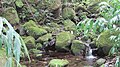
 Waterfall site at headwaters
 -
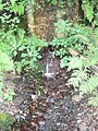 Spring and old water pipe at headwaters
 -
 Old ʻauwai above the stream
 -
 Overgrown trailhead at ʻĀhuimanu Stream and Hui Kelu St.
 -
 ʻĀhuimanu Stream crossing
 -
 Low terrace wall
 -
 Low terrace wall surrounded by saplings


References[edit]
- ^ "National Register Information System". National Register of Historic Places. National Park Service. July 9, 2010.
- ^ a b c d "National Park Service: National Register of Historic Places: Inventory – Nomination Form #73000669". Retrieved January 17, 2010.
- ^ "Kahaluu Pond Peril (digitized newspaper clippings)". July 1970. Retrieved January 17, 2010.
- ^ L. Woodward (1985). "Ahuimanu: Site 80-10-1165". Archived from the original on September 18, 2009. Retrieved January 18, 2010.
- ^ "State Historic Preservation Division: Historic Preserves and Site Curatorship". Retrieved January 18, 2010.
- ^ Dayle Turner (July 1996). "Ahuimanu Valley". Retrieved January 18, 2010.
- ^ "Google maps: Hui Kelu Street". Retrieved January 18, 2010.
| Topics | |
|---|---|
| Lists by state |
|
| Lists by insular areas | |
| Lists by associated state | |
| Other areas | |
| Related | |