
Kahatchie, Talladega County, Alabama
Kahatchie, Alabama | |
|---|---|
 Kahatchie, Alabama  Kahatchie, Alabama | |
| Coordinates: 33°12′08″N 86°24′30″W / 33.20222°N 86.40833°W | |
| Country | United States |
| State | Alabama |
| County | Talladega |
| Elevation | 495 ft (151 m) |
| Time zone | UTC-6 (Central (CST)) |
| • Summer (DST) | UTC-5 (CDT) |
| Area code(s) | 256 & 938 |
| GNIS feature ID | 164208[1] |
Kahatchee, also known as Handytown, Achates, Cohatchie, or Keyhatchie, is an unincorporated community in Talladega County, Alabama, United States.
History[edit]
The community's name comes from the same name of an Upper Creek town which was located here. It also lends its name to nearby Kahatchee Creek and the Kahatchie Hills.[2] In Creek, Kahatchie means "cane creek", in reference to the river cane which grows along waterways throughout Alabama.[3] A post office called Handytown was established in 1873, and remained in operation until it was discontinued in 1874. A post office was then operated in the area under the name Achates from 1882 until it was closed in 1894.[4]
References[edit]
- ^ "Kahatchie". Geographic Names Information System. United States Geological Survey, United States Department of the Interior.
- ^ Wright, Jr., Amos J. (2003). Historic Indian Towns in Alabama, 1540-1838. University of Alabama Press. p. 95. ISBN 0-8173-1251-X.
- ^ Read, William A. (1984). Indian Place Names in Alabama. Tuscaloosa: The University of Alabama Press. p. 37. ISBN 0-8173-0231-X.
- ^ "Talladega County". Jim Forte Postal History. Retrieved October 29, 2014.
Municipalities and communities of Talladega County, Alabama, United States | ||
|---|---|---|
| Cities | 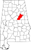 | |
| Towns | ||
| CDPs | ||
| Unincorporated communities | ||
| Ghost town | ||
| Footnotes | ‡This populated place also has portions in an adjacent county or counties | |
This Talladega County, Alabama state location article is a stub. You can help Wikipedia by expanding it. |