Cauvery railway station
This article may rely excessively on sources too closely associated with the subject, potentially preventing the article from being verifiable and neutral. (February 2019) |
Kaveri | |
|---|---|
 A train cruises over Kaveri river next to the station near Pallipalayam, Tamil Nadu | |
| General information | |
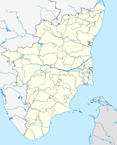
| Location | Cauvery RS, Pallipalayam, Tamil Nadu |
| Owned by | Indian Railways |
| Line(s) | Jolarpettai–Shoranur line |
| Platforms | 2 |
| Tracks | 4 |
| Construction | |
| Structure type | Standard on-ground station |
| Parking | Available |
| Bicycle facilities | Not Available |
| Other information | |
| Status | Active |
| Station code | CV |
| Fare zone | Southern Railway zone |
| History | |
| Electrified | Yes |
| Previous names | Madras and Southern Mahratta Railway |
| Location | |
Salem–Palakkad line | |||||||||||||||||||||||||||||||||||||||||||||||||||||||||||||||||||||||||||||||||||||||||||||||||||||||||||||||||||||||||||||||||||||||||||||||||||||||||||||||||||||||||||||||||||||||||||||||||||||||||||||||||||||||||||||||||||||||||||||||||||||||||||||||||||||||||||||||||||||||||||||||||||||||||||||||||||||||||||||||||||||||||||||||||||||||||||||||||||||||||||||||||||||||||||||||||||||||||||||||||||||||||||||||||||||||||||||||||||||||||||||||||||||||||||||||||||||||||||||||||||||
|---|---|---|---|---|---|---|---|---|---|---|---|---|---|---|---|---|---|---|---|---|---|---|---|---|---|---|---|---|---|---|---|---|---|---|---|---|---|---|---|---|---|---|---|---|---|---|---|---|---|---|---|---|---|---|---|---|---|---|---|---|---|---|---|---|---|---|---|---|---|---|---|---|---|---|---|---|---|---|---|---|---|---|---|---|---|---|---|---|---|---|---|---|---|---|---|---|---|---|---|---|---|---|---|---|---|---|---|---|---|---|---|---|---|---|---|---|---|---|---|---|---|---|---|---|---|---|---|---|---|---|---|---|---|---|---|---|---|---|---|---|---|---|---|---|---|---|---|---|---|---|---|---|---|---|---|---|---|---|---|---|---|---|---|---|---|---|---|---|---|---|---|---|---|---|---|---|---|---|---|---|---|---|---|---|---|---|---|---|---|---|---|---|---|---|---|---|---|---|---|---|---|---|---|---|---|---|---|---|---|---|---|---|---|---|---|---|---|---|---|---|---|---|---|---|---|---|---|---|---|---|---|---|---|---|---|---|---|---|---|---|---|---|---|---|---|---|---|---|---|---|---|---|---|---|---|---|---|---|---|---|---|---|---|---|---|---|---|---|---|---|---|---|---|---|---|---|---|---|---|---|---|---|---|---|---|---|---|---|---|---|---|---|---|---|---|---|---|---|---|---|---|---|---|---|---|---|---|---|---|---|---|---|---|---|---|---|---|---|---|---|---|---|---|---|---|---|---|---|---|---|---|---|---|---|---|---|---|---|---|---|---|---|---|---|---|---|---|---|---|---|---|---|---|---|---|---|---|---|---|---|---|---|---|---|---|---|---|---|---|---|---|---|---|---|---|---|---|---|---|---|---|---|---|---|---|---|---|---|---|---|---|---|---|---|---|---|---|---|---|---|---|---|---|---|---|---|---|---|---|---|---|---|---|---|---|---|---|---|---|---|---|---|---|---|---|---|---|---|---|---|---|---|---|---|---|---|---|---|---|---|---|---|---|---|---|---|---|---|---|---|---|---|---|---|---|---|---|---|---|---|---|---|---|---|---|---|---|---|---|---|---|---|---|---|---|---|---|---|---|---|---|---|---|---|---|
| |||||||||||||||||||||||||||||||||||||||||||||||||||||||||||||||||||||||||||||||||||||||||||||||||||||||||||||||||||||||||||||||||||||||||||||||||||||||||||||||||||||||||||||||||||||||||||||||||||||||||||||||||||||||||||||||||||||||||||||||||||||||||||||||||||||||||||||||||||||||||||||||||||||||||||||||||||||||||||||||||||||||||||||||||||||||||||||||||||||||||||||||||||||||||||||||||||||||||||||||||||||||||||||||||||||||||||||||||||||||||||||||||||||||||||||||||||||||||||||||||||||
Source: Google Maps
| |||||||||||||||||||||||||||||||||||||||||||||||||||||||||||||||||||||||||||||||||||||||||||||||||||||||||||||||||||||||||||||||||||||||||||||||||||||||||||||||||||||||||||||||||||||||||||||||||||||||||||||||||||||||||||||||||||||||||||||||||||||||||||||||||||||||||||||||||||||||||||||||||||||||||||||||||||||||||||||||||||||||||||||||||||||||||||||||||||||||||||||||||||||||||||||||||||||||||||||||||||||||||||||||||||||||||||||||||||||||||||||||||||||||||||||||||||||||||||||||||||||
Cauvery railway station (station code: CV) is an NSG–6 category Indian railway station in Salem railway division of Southern Railway zone.[1] It is a railway station in Pallipalayam in Namakkal district of Tamil Nadu. The name is derived from Kaveri River, which flows in its close proximity.[citation needed]
Location and layout[edit]
It is situated in between Erode Junction railway station and Sankaridurg railway station (and Salem Junction) in the Chennai Central–Trivandrum section. It is located near the city of Erode, just 6 km from it. It lies in the busy section of Chennai–Trivandrum in Salem railway division. Kaveri railway station is operated by the Chennai-headquartered Southern Railways of the Indian Railways. The station is used as shuttle station for Erode Junction. All the passenger trains running between Erode Junction and Salem Junction will have a stop at here.[2]
References[edit]
- ^ "SOUTHERN RAILWAY LIST OF STATIONS AS ON 01.04.2023 (CATEGORY- WISE)" (PDF). Portal of Indian Railways. Centre For Railway Information Systems. 1 April 2023. p. 11. Archived from the original (PDF) on 23 March 2024. Retrieved 3 May 2024.
- ^ "Kaveri/CV Railway Station". Indian Railway Info. Retrieved 2 October 2011.
11°21′03″N 77°45′39″E / 11.350763°N 77.760825°E


