
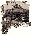
Komáří hůrka
| Komáří hůrka | |
|---|---|
 Mueckenberg und seine beiden Gaststätten | |
| Highest point | |
| Elevation | 807.5 m n.m. (2,649 ft) |
| Coordinates | 50°42′24″N 13°51′24″E / 50.70667°N 13.85667°E |
| Geography | |
 Komáří hůrka | |
| Parent range | Ore Mountains |
| Geology | |
| Mountain type | biotite gneiss with tin ore deposits |
| Climbing | |
| Access | 1568 by the tin mining industry |
Komáří hůrka (German: Mückenberg) is one of the highest mountains in the Eastern Ore Mountains on the territory of the Czech Republic.
Location and surroundings[edit]
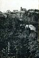
Komáří hůrka lies northeast of Krupka (Graupen) and southeast of Cínovec (Böhmisch Zinnwald) immediately on the steepest section of the Ore Mountain escarpment. As a result, it is a good observation point, from which there are views in almost all directions of the compass. In addition the characteristic appearance of a fault block mountain range with its steep escarpment falling away to the south is very clearly seen from this part of the Ore Mountains.
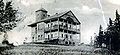
Historic photo gallery[edit]
-
 View around 1896
 -
 View around 1904
 -
 View around 1908
 -
 Around 1918


External links[edit]
Wikimedia Commons has media related to Komáří hůrka.
| Authority control databases: National |
|---|
This Ore Mountains article is a stub. You can help Wikipedia by expanding it. |