
Laon station
Laon | |||||||||||||||||||||||||||||||||
|---|---|---|---|---|---|---|---|---|---|---|---|---|---|---|---|---|---|---|---|---|---|---|---|---|---|---|---|---|---|---|---|---|---|
 Entrance to the station | |||||||||||||||||||||||||||||||||
| General information | |||||||||||||||||||||||||||||||||
| Location | Place des droits de l'Homme 02000 Laon | ||||||||||||||||||||||||||||||||
| Coordinates | 49°34′14″N 3°37′27″E / 49.57061667°N 3.624211111°E | ||||||||||||||||||||||||||||||||
| Owned by | SNCF | ||||||||||||||||||||||||||||||||
| Line(s) | Reims-Laon railway | ||||||||||||||||||||||||||||||||
| Other information | |||||||||||||||||||||||||||||||||
| Station code | 87296012 | ||||||||||||||||||||||||||||||||
| Services | |||||||||||||||||||||||||||||||||
| |||||||||||||||||||||||||||||||||
Laon is a railway station serving the town Laon.,[1] Aisne department, northern France. It was built in 1857 by Chemins de Fer du Nord. The station is served by regional trains to Paris, Amiens, Aulnoye-Aymeries and Reims.[2][3]
History[edit]
Chemins de Fer du Nord operates the station at the opening of the line section in Laon on September 1, 1853. It opens the section of Villers-Cotterets in Laon on June 2, 1862.[4]
In 2016, according to SNCF estimates, the station's annual attendance is 777,328 passengers, after 805,082 travelers in 2015 and 842,067 travelers in 2014[5]
A parking for vehicles is arranged around the station.[6]
- The station in the 1920s
-
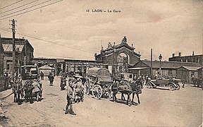 The station around 1920.
 -
 The station around 1925.
 -
 The station around 1928.


References[edit]
- ^ Panique en gare de Laon avant la grève des cheminots Courrier Picard
- ^ "Plan des lignes TER Hauts-de-France" (PDF). www.ter.sncf.com (in French). Retrieved 20 April 2022.
- ^ "Fiche Horaire C 10" (PDF). TER Grand Est. Retrieved 20 April 2022.
- ^ Gare SNCF de Laon: History
- ^ Fréquentation en gares – Laon SNCF Open Data. 25 May 2018.
- ^ Laon Guide
| Authority control databases: Geographic |
|---|
This article about a railway station in the Hauts-de-France région of France is a stub. You can help Wikipedia by expanding it. |