
Maugherow Peninsula
Machaire Eabha | |
|---|---|
 Maugherow Peninsula (Red) within County Sligo | |
 | |
| Geography | |
| Location | Ireland |
| Adjacent to | |
| Area | 57.2 km2 (22.1 sq mi) |
| Administration | |
| County | Sligo |
| Demographics | |
| Population | 3,105 (2016[1]) |
| Pop. density | 54.3/km2 (140.6/sq mi) |
The Maugherow Peninsula (Irish: Machaire Eabha)[2] is the largest and westernmost peninsula of County Sligo, Ireland. It is also less commonly referred to as the Raghly Peninsula, after Raghly Point (Irish: Gob Reachla), which is itself a headland of the peninsula. The peninsula acts as the northern boundary of Sligo Bay.
The peninsula's rugged coastline and exposed location has made it far less popular as a tourist destination than some of Sligo's other peninsulas, such as Mullaghmore, Rosses Point and Coolera. The area is largely flat and agricultural in nature, characterised by ribbon development.[3] Carney is the sole nucleated village on the peninsula proper, while the larger town of Grange is located on the margins of the peninsula.
Places of interest[edit]
- Ballygilgan Nature Reserve
- Lissadell House[4]
- Knocklane Fort
- Raghly Harbour
- Streedagh Armada wrecksite
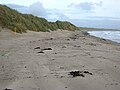
- Streedagh Beach
- Yellow Strand Beach
Gallery[edit]
-
 Ballygilgan
 -
 Raghly Harbour
 -
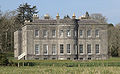 Lissadell House
 -
 Streedagh
 -
 Yellow Strand


_-_geograph.org.uk_-_978000.jpg)
See also[edit]
References[edit]
54°21′25″N 8°36′50″W / 54.357°N 8.614°W

This article related to the geography of County Sligo, Ireland is a stub. You can help Wikipedia by expanding it. |