Mezná (Pelhřimov District)
Mezná | |
|---|---|
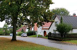
 Centre of Mezná | |
| Coordinates: 49°20′50″N 15°12′41″E / 49.34722°N 15.21139°E | |
| Country | |
| Region | Vysočina |
| District | Pelhřimov |
| First mentioned | 1362 |
| Area | |
| • Total | 8.24 km2 (3.18 sq mi) |
| Elevation | 636 m (2,087 ft) |
| Population (2023-01-01)[1] | |
| • Total | 156 |
| • Density | 19/km2 (49/sq mi) |
| Time zone | UTC+1 (CET) |
| • Summer (DST) | UTC+2 (CEST) |
| Postal code | 393 01 |
| Website | www |
Mezná is a municipality and village in Pelhřimov District in the Vysočina Region of the Czech Republic. It has about 200 inhabitants.
Administrative parts[edit]
The village of Vratišov is an administrative part of Mezná.
Geography[edit]
Mezná is located about 9 kilometres (6 mi) south of Pelhřimov and 27 km (17 mi) west of Jihlava. It lies in the Křemešník Highlands. The highest point is the hill Bukový kopec at 703 m (2,306 ft) above sea level. The Želivka River (called Hejlovka on the upper course) originates in the municipal territory, on the northern slopes of Bukový kopec. The Bělá stream flows along the eastern municipal border and together with its nameless tributary, they supply several small fish ponds located in the municipality.
References[edit]
External links[edit]
Wikimedia Commons has media related to Mezná (Pelhřimov District).

