
Midway, New Mexico
Midway, New Mexico | |
|---|---|
 Midway | |
| Coordinates: 33°17′40″N 104°27′0″W / 33.29444°N 104.45000°W | |
| Country | United States |
| State | New Mexico |
| County | Chaves |
| Area | |
| • Total | 2.49 sq mi (6.44 km2) |
| • Land | 2.48 sq mi (6.44 km2) |
| • Water | 0.00 sq mi (0.01 km2) |
| Elevation | 3,573 ft (1,089 m) |
| Population | |
| • Total | 818 |
| • Density | 329.18/sq mi (127.09/km2) |
| Time zone | UTC-7 (Mountain (MST)) |
| • Summer (DST) | UTC-6 (MDT) |
| ZIP code | 88230 |
| Area code | 575 |
| FIPS code | 35-48480 |
| GNIS feature ID | 0923629 |
Midway is an unincorporated community and census-designated place (CDP) in Chaves County, New Mexico. The population was 971 at time of the 2010 census.[3]
Geography[edit]
Midway is located in central Chaves County at 33°17′40″N 104°27′0″W / 33.29444°N 104.45000°W, 9 miles (14 km) southeast of the center of Roswell, the county seat. U.S. Route 285 forms the western edge of the CDP, leading northwest to Roswell and south 33 miles (53 km) to Artesia. New Mexico State Road 2 runs through the center of the community, joining US 285 at the CDP's northwest corner and running southeast 15 miles (24 km) to Hagerman.
According to the United States Census Bureau, the Midway CDP has a total area of 2.5 square miles (6.4 km2), all land.[3]
Demographics[edit]
| Census | Pop. | Note | %± |
|---|---|---|---|
| 2010 | 971 | — | |
| 2020 | 818 | −15.8% | |
| U.S. Decennial Census[4][2] | |||
Education[edit]
It is in the Roswell Independent School District.[5]
References[edit]
- ^ "ArcGIS REST Services Directory". United States Census Bureau. Retrieved October 12, 2022.
- ^ a b "Census Population API". United States Census Bureau. Retrieved October 12, 2022.
- ^ a b "Geographic Identifiers: 2010 Demographic Profile Data (G001): Midway CDP, New Mexico". U.S. Census Bureau, American Factfinder. Archived from the original on February 12, 2020. Retrieved October 17, 2014.
- ^ "Census of Population and Housing". Census.gov. Retrieved June 4, 2016.
- ^ "2020 CENSUS - SCHOOL DISTRICT REFERENCE MAP: Chaves County, NM" (PDF). U.S. Census Bureau. Retrieved June 28, 2022.
Municipalities and communities of Chaves County, New Mexico, United States | ||
|---|---|---|
| City | 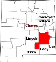 | |
| Towns | ||
| CDP | ||
| Unincorporated community | ||
| Ghost town | ||
This New Mexico state location article is a stub. You can help Wikipedia by expanding it. |