
Mitchell garrison
| Mitchell garrison | |
|---|---|
 The home in the second half of the 19th century | |
 | |
| General information | |
| Architectural style | Garrison |
| Location | North Yarmouth, Province of Massachusetts Bay |
| Address | Smith Street |
| Coordinates | 43°47′28″N 70°10′03″W / 43.7911°N 70.1674°W |
| Completed | 1728 |
| Technical details | |
| Floor count | 2 |
The Mitchell garrison was an important building in what was, at the time, North Yarmouth, Province of Massachusetts Bay.[1] Built in 1728 at the rear of today's Holy Cross Cemetery, adjacent to Riverside Cemetery on a bluff around 50 feet (15 m) above the Royal River, it was used as a stockade during the Indian wars. Despite its later usage, the term "garrison" refers to its architectural style.
The home's first owner was Jacob Mitchell (c. 1672–1744), a dean and a founder of the nearby Meetinghouse under the Ledge, which stood between 1729 and 1836. His son, Jacob III, also became a deacon there.[2]
A tunnel was built from the home's cellar to the river. The dirt path that looks like it leads to the water is actually the original stage road, formerly lined with elm trees. Mitchell's family lived in the house between around 1729 and 1799, when one of Mitchell's sons, David, owned it.[3] It then became the home of the Whitcombs, whose name is preserved on a street off Princes Point Road. It was demolished about 1900, and the farm land was purchased in 1916 to be replaced by the cemetery.[4] The cemeteries occupy what was the northern end of today's Smith Street.[5]
-
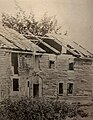 The building shortly before its destruction in the early 20th century

See also[edit]
References[edit]
- ^ "Mitchell Garrison" - History of Yarmouth ME
- ^ The Congregational Quarterly, Volume 13. 1871. p. 36.
- ^ Underhill, Lora Altine Woodbury (1910). Descendants of Edward Small of New England, and the Allied Families, with Tracings of English Ancestry. p. 386.
- ^ Ancient North Yarmouth and Yarmouth, Maine 1636-1936: A History, William Hutchinson Rowe (1937)
- ^ Annual Report Town of Yarmouth 2007 – The University of Maine