
Monivong Bridge
Monivong Bridge | |
|---|---|
 Bird's Eye View of Preah Monivong Bridge | |
| Coordinates | 11°31′53″N 104°55′59″E / 11.53131°N 104.93292°E |
| Crosses | Bassac River |
| Locale | Phnom Penh, Cambodia |
| Official name | ស្ពានព្រះមុនីវង្ស |
| Characteristics | |
| Total length | 269.5 m |
| Width | 2 x 14 m |
| Location | |
 | |

Monivong Bridge (Khmer: ស្ពានព្រះមុនីវង្ស) is a heavily trafficked bridge in Phnom Penh, Cambodia. It bridges the Bassac River near the end of National Highway 2 to southern Cambodia and lies along the National Highway 1 which connects the city to eastern Cambodia and Vietnam.[1]
On the eastern shore lies the Chhba Ampeou Market.
Images[edit]
-
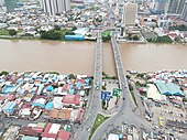 Aerial view of Preah Monivong Bridge View from Chbar Ampov
 -
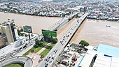 Preah Monivong Bridge View from Flyover
 -
 Aerial View of the Bridge and Surrounding Area (Bassac River, Monivong Boulevard etc.)


References[edit]
Wikimedia Commons has media related to Monivong Bridge.
11°31′52.7″N 104°55′58.5″E / 11.531306°N 104.932917°E
This article about a bridge in Cambodia is a stub. You can help Wikipedia by expanding it. |