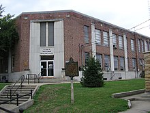
Monticello Historic Commercial District
Monticello Historic Commercial District | |
| Location | Main and Columbus Sts., Monticello, Kentucky |
|---|---|
| Coordinates | 36°49′46″N 84°50′57″W / 36.82944°N 84.84917°W |
| Area | 2.4 acres (0.97 ha) |
| Architectural style | Mixed (more Than 2 Styles From Different Periods) |
| NRHP reference No. | 82001577[1] |
| Added to NRHP | October 29, 1982 |
The Monticello Historic Commercial District, around Main and Columbus Streets in Monticello, Kentucky, is a 2.4 acres (0.97 ha) historic district which was listed on the National Register of Historic Places in 1982.[1]
It includes a United States Post Office among its 11 contributing buildings.[2]

The modern Wayne County Courthouse is excluded from the district.[2]
References[edit]
- ^ a b "National Register Information System". National Register of Historic Places. National Park Service. November 2, 2013.
- ^ a b Robert M. Polsgrove (September 1982). "National Register of Historic Places Inventory/Nomination: Monticello Historic Commercial District". National Park Service. Retrieved April 10, 2018.


