
Mount Kinesava
| Mount Kinesava | |
|---|---|
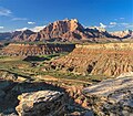
 Mount Kinesava, southwest aspect | |
| Highest point | |
| Elevation | 7,285 ft (2,220 m)[1] |
| Prominence | 685 ft (209 m)[1] |
| Parent peak | The West Temple (7,810 ft)[2] |
| Isolation | 1.06 mi (1.71 km)[2] |
| Coordinates | 37°11′51″N 113°01′50″W / 37.197571°N 113.030571°W[1] |
| Geography | |
 Mount Kinesava Location in Utah  Mount Kinesava Mount Kinesava (the United States) | |
| Country | United States |
| State | Utah |
| County | Washington |
| Protected area | Zion National Park |
| Parent range | Markagunt Plateau Colorado Plateau |
| Topo map | USGS Springdale West |
| Geology | |
| Age of rock | Jurassic |
| Type of rock | Navajo sandstone |
| Climbing | |
| Easiest route | class 4 scrambling[2] |
Mount Kinesava is a 7,285-foot (2,220 m) sandstone mountain summit located in Zion National Park, in Washington County of southwest Utah, United States.[3]
Description[edit]
Mount Kinesava is located immediately west of Springdale, towering 3,400 feet (1,000 meters) above the town and the floor of Zion Canyon. Precipitation runoff from this mountain drains into tributaries of the Virgin River. Its nearest higher neighbor is The West Temple, 1.06 mi (1.71 km) to the northeast. Other notable mountains within view from the summit include The Watchman 2.95 mi (4.75 km) to the east-southeast, Bridge Mountain 3.6 mi (5.8 km) to the east-northeast, and Mount Spry is positioned 4 mi (6.4 km) to the northeast.[1] This feature's name was officially adopted in 1934 by the U.S. Board on Geographic Names.[3] It is so named for Kinesava, the Paiute deity of trickery.[4][5]
Climate[edit]
Spring and fall are the most favorable seasons to visit Mount Kinesava. According to the Köppen climate classification system, it is located in a Cold semi-arid climate zone, which is defined by the coldest month having an average mean temperature below 32 °F (0 °C), and at least 50% of the total annual precipitation being received during the spring and summer. This desert climate receives less than 10 inches (250 millimeters) of annual rainfall, and snowfall is generally light during the winter.[6]
Geology[edit]

Stratification of sandstone deposits from vast dune fields laid down 175 to 200 million years ago can be seen exposed on the south aspect of the mountain. The uppermost 1,500 feet of this mountain is composed of light-colored Jurassic Navajo Sandstone. Below that layer is deep-red sandstone of the Kayenta Formation, probably best known for its dinosaur tracks, overlying the Springdale Sandstone Member. Continuing lower are the Whitmore Point Member and Dinosaur Canyon Member of the Moenave Formation. Near the base is the Petrified Forest Member of the Chinle Formation, surrounded by landslide deposits.[7]
Gallery[edit]
-

-
-

-
-
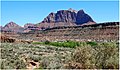
 Mt. Kinesava centered, The Sundial to left
 -

-
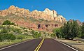
 Mt. Kinesava (left), The West Temple (right) from southeast on Hwy 9
 -
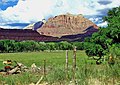
 Mt. Kinesava (left), The West Temple straight ahead
 -

.jpg)

.jpg)
.jpg)


See also[edit]
References[edit]
- ^ a b c d "Mount Kinesava, Utah". Peakbagger.com.
- ^ a b c "Kinesava, Mount - 7,285' UT". listsofjohn.com. Retrieved 2020-09-01.
- ^ a b U.S. Geological Survey Geographic Names Information System: Mount Kinesava
- ^ Who Is “Kinesava”?, Zion Canyon Community, Kinesava.com
- ^ Ron Kay, Ron Kay's Guide to Zion National Park, Countryman Press, 2008, page 94.
- ^ "Zion National Park, Utah, USA - Monthly weather forecast and Climate data". Weather Atlas. Archived from the original on January 27, 2019. Retrieved 31 August 2020.
- ^ Geologic Map of the St. George and the East Part of the Clover Mountains 30' x 60' Quadrangles, Washington and Iron Counties, Utah. Utah Geological Survey, 2010, page 19
External links[edit]
- Zion National Park National Park Service
- Weather: Mount Kinesava
- Mt. Kinesava Rock Climbing: mountainproject.com