Municipality of Podvelka
Municipality of Podvelka
Občina Podvelka | |
|---|---|
 | |
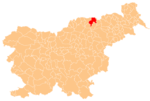
 Location of the Municipality of Podvelka in Slovenia | |
| Coordinates: 46°36′N 15°21′E / 46.600°N 15.350°E | |
| Country | |
| Government | |
| • Mayor | Anton Kovše |
| Area | |
| • Total | 103.9 km2 (40.1 sq mi) |
| Population (July 1, 2018)[1] | |
| • Total | 2,354 |
| • Density | 23/km2 (59/sq mi) |
| Time zone | UTC+01 (CET) |
| • Summer (DST) | UTC+02 (CEST) |
| Website | www |
The Municipality of Podvelka (pronounced [pɔˈdʋeːlka]; Slovene: Občina Podvelka) is a municipality in the traditional region of Styria in northern Slovenia. The seat of the municipality is the town of Podvelka. The Municipality of Podvelka–Ribnica was created in 1994, and it then split into the Municipality of Ribnica na Pohorju and the Municipality of Podvelka in 1998.[2]
Settlements[edit]
In addition to the municipal seat of Podvelka, the municipality also includes the following settlements:
References[edit]
- ^ a b "Občina Podvelka". Statistični urad Republike Slovenije. Retrieved April 9, 2020.
- ^ Vzpostavitev lokalne samouprave v Republiki Sloveniji v številkah. Ljubljana: Statistični urad Republike Slovenije. 2007. p. 98. Retrieved March 7, 2020.
External links[edit]
 Media related to Municipality of Podvelka at Wikimedia Commons
- Municipality of Podvelka on Geopedia
- Municipality of Podvelka website


