
Near Northside Historic District (Columbus, Ohio)
Near Northside Historic District | |
 Contributing houses | |
 Interactive map | |
| Location | Off State Route 315, Columbus, Ohio |
|---|---|
| Coordinates | 39°59′05″N 83°00′45″W / 39.984722°N 83.0125°W |
| NRHP reference No. | 80003001[1] |
| Added to NRHP | June 4, 1980 |
The Near Northside Historic District is a historic district in Columbus, Ohio. The large district encompasses portions of the University District, Harrison West, and nearly all of Victorian Village.
Description[edit]
The district was listed on the National Register of Historic Places in 1980.[1] The district is made up of about 70 square blocks, with houses developed generally between 1870 and 1920. Architectural styles range from Italianate to Second Empire, Eastlake, Romanesque Revival, and Shingle Style, with some vernacular buildings as well.[2] District boundaries overlap with the city's Victorian Village Historic District.
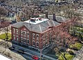
The First Avenue School, on the Columbus Register of Historic Properties, also lies within this district.
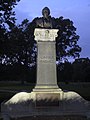
Gallery[edit]
-

-
-

-

-
-
 Everett Middle School / Old North High School

_-_364.jpg)


.jpg)
See also[edit]
References[edit]
- ^ a b "National Register Information System". National Register of Historic Places. National Park Service. March 13, 2009.
- ^ "National Register of Historic Places Registration Form". National Park Service. Retrieved January 8, 2021.
External links[edit]
 Media related to Near Northside Historic District (Columbus, Ohio) at Wikimedia Commons

This Columbus, Ohio-related article is a stub. You can help Wikipedia by expanding it. |