
O. H. Bailey
O. H. Bailey | |
|---|---|
 | |
| Born | Oakley Hoopes Bailey June 14, 1843[1] Mahoning County, Ohio, U.S. |
| Died | August 13, 1947 (aged 104)[1] Alliance, Ohio, U.S. |
| Occupation | Map maker |
| Known for | Birds eye view maps, Panoramic maps |
Oakley Hoopes Bailey (June 14, 1843 – August 13, 1947) was a prolific panoramic map creator for several decades.[1][2] He produced 374 maps from 1871 until he retired in 1927. Aerial photography replaced the months long process of capturing views drawn in panoramic maps to a process that could be done in a day.[3] The Library of Congress has a collection of his maps.[4]
He was born in Mahoning County, Ohio and studied at Mount Union College in Alliance, Ohio in 1862. In 1864, he served with the 143d Ohio Volunteer Militia, Company F, before returning to Mount Union and graduating in 1866. He began making maps in 1871, moved to Boston,[3] and made many maps of areas in Massachusetts and Connecticut.
He died in Alliance, Ohio at age 104.[3]
Maps[edit]
-
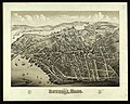
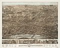
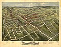
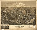
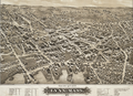 Lynn, Massachusetts (1879)
 -
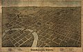
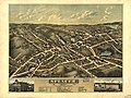
 Worcester, Massachusetts (1878)
 -
-
-
-
-

-
-
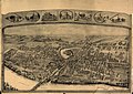
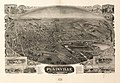 Plainville, Connecticut (1907)
 -

-

-

-

-
-

-
-

-
-

-

-

-

-
-

-

-

-
-


,_Connecticut)._LOC_91680391.jpg)


References[edit]
- ^ a b c "The History of Bird's Eye View Maps". Vintage City Maps. Vintage City Maps. 14 April 2016. Retrieved 30 November 2020.
- ^ "Browsing Bird's-Eye View Maps by Author "Bailey%2C O. H. %28Oakley Hoopes%29%2C 1843-1947."".
- ^ a b c "The History of Bird's Eye View Maps". 14 April 2016.
- ^ bailey, o h (oakley hoopes). "Search results from Panoramic Maps, Available Online, Bailey, O. H. (Oakley Hoopes)". Library of Congress.
| International | |
|---|---|
| National | |