
Ossulston House
| Ossulston House | |
|---|---|
 | |
 | |
| General information | |
| Architectural style | Georgian |
| Classification | Grade II |
| Location | Hadley, London |
| Estimated completion | 1764 |
Ossulston House is a Grade II listed building opposite Joslin's Pond in Hadley Green Road, Hadley, to the north of Chipping Barnet. It is one of what was an almost complete line of houses between Chipping Barnet and Monken Hadley along the east side of Hadley Green which were built in the 18th and 19th centuries as wealthy merchants from London populated the area.[1]
History[edit]
The house was built soon after 1764 by sugar refiner John Horton on the site of the Rose and Crown inn and acquired in 1786 by William Makepeace Thackeray, grandfather of the novelist of the same name,[2] who is buried in nearby St Mary the Virgin church.[3]
It was once owned by the Earl of Tankerville who used it when he was visiting from his country home of Chillingham Castle in Northumberland.[4] The Earls also held the title of Baron Ossulston, after the Hundred of Ossulston.[5]
The certificate issued in 1858 as a result of the case of Monro v. Proctor, in respect of monies paid when a railway was driven through Monken Hadley Common, shows the owners of Ossulston House (1) to have been the Trustees of Conference Hall, Mildmay Park, and of Ossulston House (2) to have been W. Joslin. Both in the occupation of the Earl of Tankerville.[6]
The house may have been used as a nursing home.[7] Around 1965 it was occupied by Mr and Mrs Keith Chapman.[8]
Architecture[edit]
The house is of red brick with stringcourses at storey height, three bays, and a rusticated Gibbs surround to the semicircular-headed doorway.[9] Iron railings at the front are broken by a four-step stairway to the front door, on each side of which are small leaded stained glass windows with avian designs. It is Grade II listed with Historic England.[10]
-
 Ossulston House entrance
 -
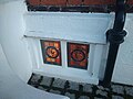 Stained glass window adjacent to the entrance
 -
 The Grange (right) with Ossulston House to the left

.jpg)

Immediately adjacent to Ossulston House at right angles is the Grade II listed The Grange with three "blind" windows facing the street.[11]
References[edit]
- ^ Duncan, Andrew. (2007). Andrew Duncan's favourite London walks: 50 classic routes exploring London's heritage. London: New Holland Publishers. p. 215. ISBN 978-1-84537-454-9.
- ^ Monken Hadley: Introduction. British History Online. Retrieved 9 February 2020.
- ^ Gove, Brenda R. A. n.d. A Guide to the Parish Church of St. Mary the Virgin, Monken Hadley. Monken Hadley. p. 23.
- ^ Community Focus: The Monken Hadley Trail. Culture 24, 9 March 2004. Retrieved 9 February 2020.
- ^ Smith, Thomas. (1833). A Topographical and Historical Account of the Parish of St. Mary-le-Bone &c. London: John Smith. p. 2.
- ^ Monken Hadley Common: Report of the Committee appointed at the Meeting of Commoners' held on Easter Tuesday, 1901, to investigate the question of Common Rights &c. Barnet Press, Barnet, 1902. p. 10.
- ^ Ossulston Convalescent Home, Mildmay Mission Hospital.
- ^ Gelder, W. H. (1991) Georgian Hadley. 5th edition. Barnet: Barnet Press. pp. 3-4.
- ^ Pevsner, Nikolaus & Bridget Cherry. (2002). The Buildings of England: London 4 North. New Haven & London: Yale University Press. p. 185. ISBN 0300096534.
- ^ Historic England. "Ossulston House (1359044)". National Heritage List for England. Retrieved 9 February 2020.
- ^ Gelder, pp. 5-6.
External links[edit]
![]() Media related to Ossulston House at Wikimedia Commons
Media related to Ossulston House at Wikimedia Commons